Loading...
Node: 4825890255
Version #4
Hiking routes Brè - Monte Boglia - Villa Luganese part1
- Edited by rbuffat
- Changeset #134466771
- Location: 46.0186671, 9.0022314
Tags
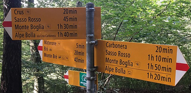
| description | 3 cartelli gialli:"Carbonera 20', Sasso Rosso 1h10, Monte Boglia 1h50; Alpe Bolla 1h20"; "Crus 20', Sasso Rosso 45', Monte Boglia 1h30; Alpe Bolla via Crus-Carbonera 1h40"; "Materone 5', Brè 20', Monte Brè 40'". Segnavia "Scenic Trail". |
|---|---|
| hiking | yes |
| image | https://upload.wikimedia.org/wikipedia/commons/thumb/1/16/Wanderwegweiser_Castra.jpg/640px-Wanderwegweiser_Castra.jpg |
| information | guidepost |
| mapillary | 55WYJd_jZG1C2OcEiBMtgQ |
| material | metal |
| support | pole |
| tourism | information |
| wikimedia_commons | File:Wanderwegweiser_Castra.jpg |
Part of
13 relations
- Relation 7204226 (as sign)
- Relation 7204231 (as sign)
- Relation 7204232 (as sign)
- Relation 7204233 (as sign)
- Relation 7204234 (as sign)
- Relation 7204235 (as sign)
- Relation 7204236 (as sign)
- Relation 7204237 (as sign)
- Relation 7204227 (as sign)
- Relation 7204228 (as sign)
- Relation 7204229 (as sign)
- Relation 7204230 (as sign)
- Relation Sentiero Lago di Lugano (17035560) (as guidepost)
Welcome to OpenStreetMap!
OpenStreetMap is a map of the world, created by people like you and free to use under an open license.
Hosting is supported by Fastly, OSMF corporate members, and other partners.
| https://openstreetmap.org/copyright | https://openstreetmap.org |
| Copyright OpenStreetMap and contributors, under an open license | |