OpenStreetMap

Akrimullah's Diary

Recent diary entries

Flashback

Two years ago, I visited Timor-Leste with the support of the Open Mapping Hub Asia Pacific to introduce OSM and Open Mapping Tools to communities and humanitarian organizations in Timor-Leste. One of the outcomes of this activity was the formation of the OSM TL community, which continues to grow to this day.

Nowadays

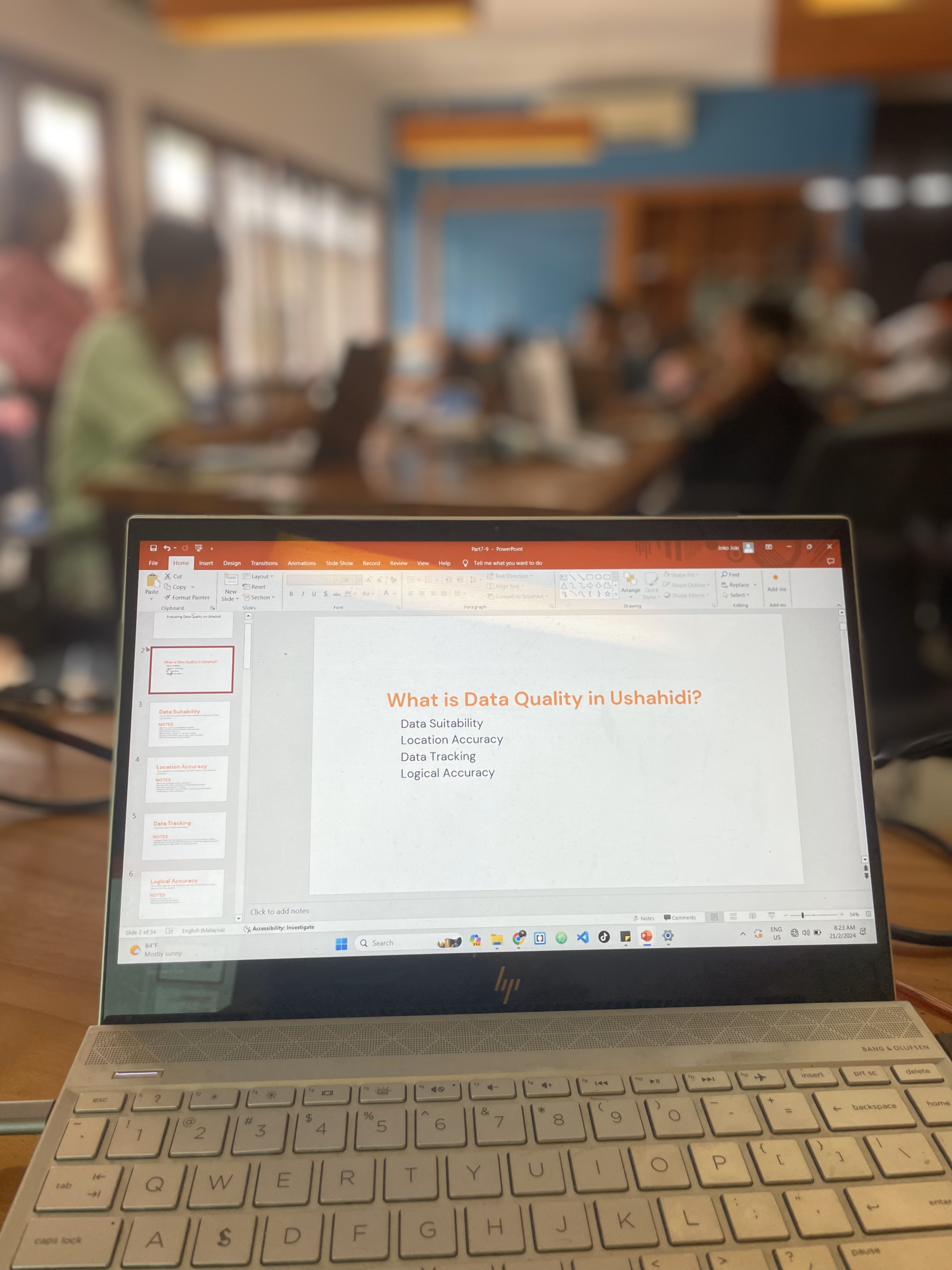
Through the support of the Open Mapping Guru program initiated by OMH Asia Pacific, G-SIG, in collaboration with OSM TL and World Vision Timor-Leste, has conducted a capacity-building activity related to the use of Ushahidi. I am very pleased to have been deployed as a Guru to facilitate this training, marking my first in-person training as one of the OM Gurus.

Reality

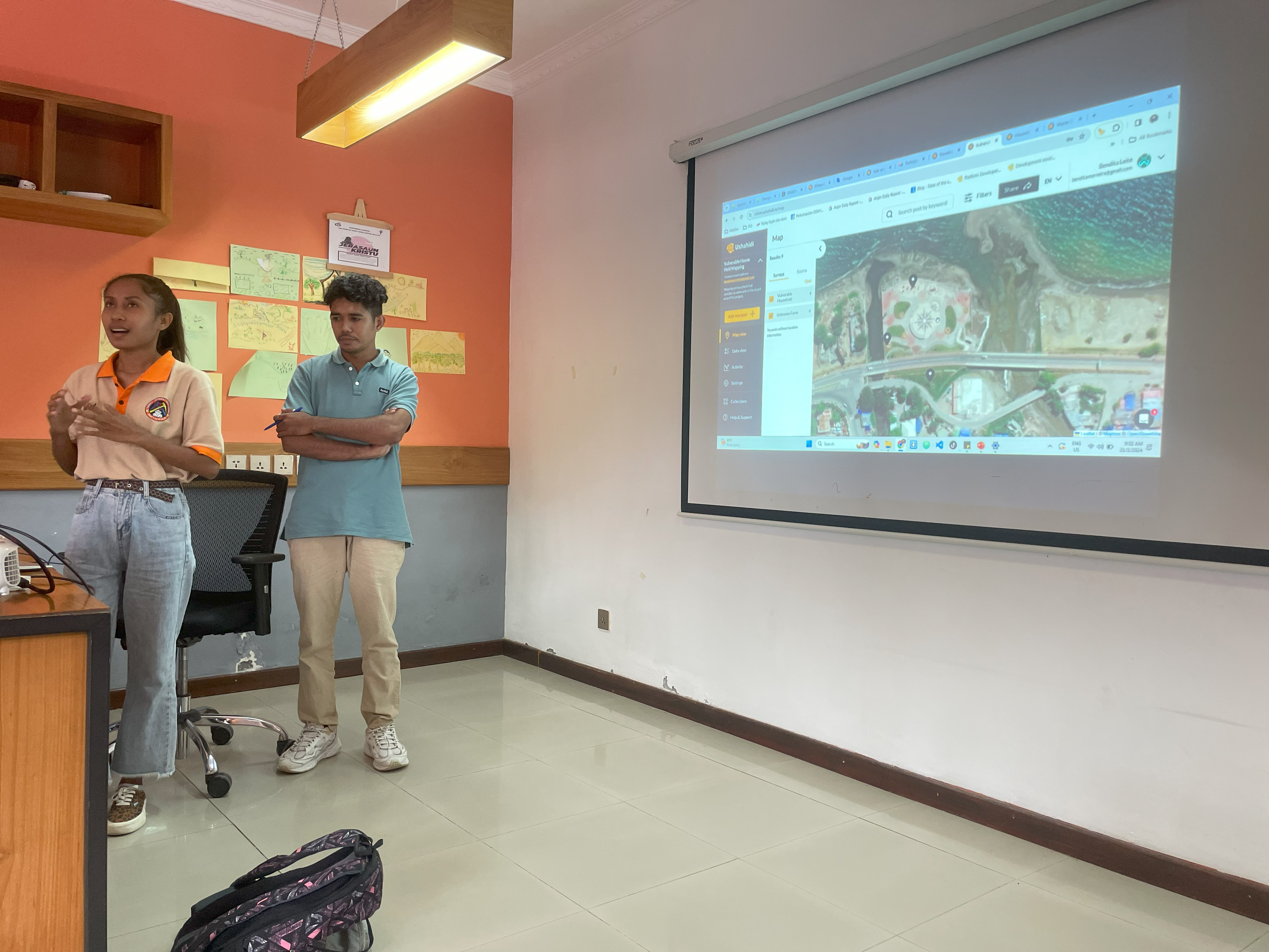
The two-day training went smoothly, and I was pleasantly surprised to see the Open Mapping and OSM community improvement in Timor-Leste. We discussed many things, especially with Maun Ponsyano. He explained many things related to the challenges and future efforts to develop the Open Mapping and OSM community in Timor-Leste. The Ushahidi training is just one step in preparing the community’s capacity to face future challenges, enabling the use of open mapping tools to achieve humanitarian and sustainable development goals. Ushahidi

Process

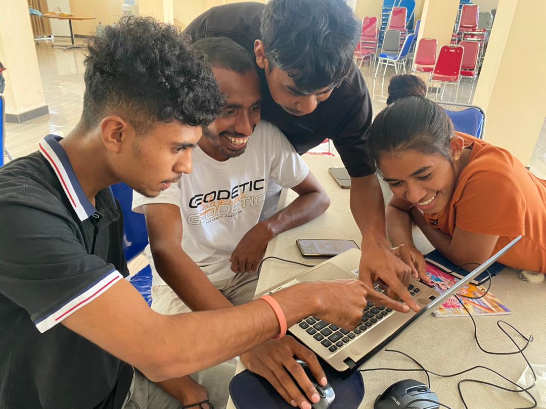
In the two days, participants absorbed information well regarding the use of Ushahidi as one of the open mapping tools. Together with the participants, as an OM Guru, I didn’t just deliver material in a one-way direction; instead, I encouraged participants to discuss and simulate the process of preparing a project that would utilize Ushahidi. From the beginning, participants were directed to think about a project that would deploy Ushahidi. In the end, participants presented their projects and received feedback from other participants and OM Gurus for future improvements. Presentation

HavingFun

We also didn’t forget to engage all participants and OM Gurus in fun games, icebreakers, and quick challenges to boost participants’ spirits amidst the simulation process of creating Ushahidi projects. One of the most exciting moments for participants was the quick challenge session, where each group out of the four had to compete to add amenities and buildings to OpenStreetMap. Ten amenities and more than 100 buildings were mapped during this very short session. Quick Challenge

FollowUp

The next step is how the OSM TL community will maximize the use of Ushahidi to support humanitarian, environmental, and other sectors in Timor-Leste. However, as an OM Guru, I will always provide support, especially in terms of updating if there are any changes or updates to the material I provide.

FinalWords

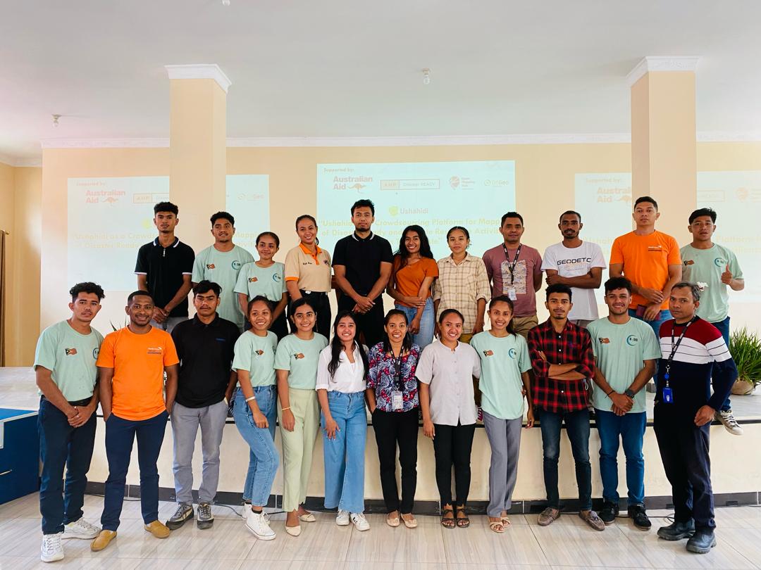
Thanks to OMH Asia Pacific, OM Guru Program, World Vision Timor Leste, G-SIG, OSM TL, and the Ushahidi Team! Training Day

Location: Lecidere, Nain Feto, Dili, East Timor

My First SOTM !!!

Posted by Akrimullah on 16 January 2023 in English.

The 21st to 25th of November was the peak of my OSM journey in 2022. I was selected as one of the SOTMA Scholars to attend the event in Legazpi, Philippines. HOT Asia Pacific HUB was the one who invited me. From Indonesia, Zainab was also selected along with me and the other scholars that came from Nepal, Sri Lanka, Vietnam, Pakistan, India, Bangladesh, and Timor Leste.

This was actually my first time visiting the Philippines. I enjoyed so much stay in Legazpi. We visited the Mayon Volcano, tried various local culinary, and played amazing race games aside from attending many choices of talks and workshops at Bicol University (the venue where SOTMA 2022 was held)

Mayon Mountain

It was wonderful to meet with the OSM community in Asia. We shared a lot of experiences, stories, and meaningful OSM journeys as that one is the one why we were at the event. I always remember every detail of the discussion I have made with almost all of the participants in the SOTMA 2022.

SOTMA 2022

I do learn a lot from the event, but there are 2 most interesting topics that I really like which are AI and Counter Mapping. Machine Learning has already been applied to OSM since a couple of years ago, SOTMA was my first time connecting directly with the developer, programmer, and contributor who are the key person of some interesting tools regarding OSM and OpenMapping Tools combined with AI. It is used widely nowadays by OSM contributors. It helps a lot to enhance the data quality. The second topic I really like is Counter Mapping. This is a novel term in my country and currently, I have the opportunity to involve in a program that is relevant to this topic in Indonesia that is funded by Booster Grants. I am happy to know that OSM can be part of fighting an injustice issue in society.

Besides attending the talks and workshops, I was given by the organizer an opportunity to share my OSM mapping activity in Indonesia. Really grateful to be able to discuss with everyone about land use mapping in Indonesia. Hopefully, land use data in OSM will have significant enrichment for the next year.

talk

OpenStreetMap Idea is really powerful to bring free and open spatial data to everyone while also involving individual and organized mappers at the same time. Asia mappers have a lot of work to do, we need to map more people, share our local knowledge, encourage new mappers and strictly take care of our data so everyone is grateful and proud of having such awesome spatial data. See ya at the next SOTM Asia !!

Btw lastly, I just want to say that meeting directly with OSM contributors was so exciting !!! they are all awesome people!!

osm

Location: Sempur, Bogor, West Java, Java, 16128, Indonesia

So in JOSM, if I wanna split a way into 3 part, it asks which one of the segment that I want to reuse the history. instead of one, i really need all segment to keep its history so the community still could track the previous mapper edits. I think it’s not fair if the rest of the segment become our data because we only split it not add the new one. Here the illustration which i refer to. Untitled

So, today my friend, an urban planner, asked whether she can download a group of land-use data in her city for research purposes. Realizing that this kind of tag in OSM particularly in Indonesia still an excommunicated object mapped, so I just wanna remind that this data is very helpful and powerful for the urban planners. She also asked me if there is a highway data that has a polygon base data not only a line so her data measurement become more accurate.

This is a good idea, have you ever map a polygon highway ???

Mapping the fitness-related object that common nowadays

I wanna share how I tag an object on the ground and transfer the information to OSM. Look at the picture below.

ourdoor CREDIT: THE GREAT OUTDOOR GYM COMPANY link at here

how it mapped? : 1. First: I’ll draw a polygon that represents the outdoor gym area 2. Figuring out the appropriate tag for this area. In my opinion, the polygon I have drawn should contain the tags at least: leisure = fitness_station, sport = gymnastic.

Any other suggestions for additional tags?

Hy everyone, I just wanna share my experience on how I really need the spatial data in OSM or other Map Platform. Basically, it began when I was on a trip to the overseas and wanna find an outdoor park that has some pull-up bar so I can start my workout morning routine. It really hard to find a single spot like this one in my map application. I decided to walk outside and found some pretty good spot to begin my workout but unfortunately it for private access for the apartment. I believe there are so many people out there like me, struggling to find a good spot for workout whether they are in their home neighbourhood or in the new area that they never visited before. with the power of OSM, I already start mapping some of this healthy spot since last month in Malaysia and Indonesia. Mostly the objects I mapped are pitch and some outdoor park that I know there are some sports tools that can be used. Here my idea of what object we could map in OSM related with healthy spot :

  • Pitch (Soccer, Tennis, Volley, etc)
  • Public Amusement Park (Usually has some nice outdoor gym)
  • Indoor Gym/Fitness Station (Add additional information on a hotel, campus or private building that has indoor Gym)
  • Swimming Pool
  • and many more in OSM sport/fitness-related tag Untitled Untitled2

    I use #healthyspotmapping as the hashtag when uploading my changeset. Hopefully, it will help everyone to catchup their fitness by knowing the good place to do a workout.
Location: RW 07, Tebet Timur, Tebet, South Jakarta, Special Region of Jakarta, Java, Indonesia