Harry Wood's Diary Comments
Diary Comments added by Harry Wood
| Post | When | Comment |
|---|---|---|
| “The Birdcage is lonely” - @OpenStreetMap engagement on Mastodon/Fediverse is streets ahead of Twitter. | It definitely seems important that the number of followers on Twitter is 10 times higher than the on Mastodon. Surely our tweets are managing to reach more people than our toots?! Could there be some other reason we get more boosts and like than retweets and stars? Well maybe a lot of our followers followed some time ago and no longer really active on twitter, or followed so many people that they no longer really engage with us. Conversely mastodon is newer and fresher, so people who are following will be more actively following (and boosting and liking). But that all goes to back-up what you’re saying essentially. I thought maybe the curious dynamic on mastodon where we have a “osm.town” grouping of users then a wider fediverse might mean we’re more likely to get lots of engagement from the users in our instance. That might mean it’s a better channel for talking to our community, but not so good for outreach. “locked down to logged in user only” hmm? oh yeah Wow ok. That’s another recent step backwards by twitter that I hadn’t noticed. The recent tweetdeck changes are messing with our ability to do @OpenStreetMap tweeting, and that’s before it goes paid-for in a few weeks time. What a mess. We may end up largely abandoning the @OpenStreetMap twitter account for those kinds of reasons anyway. |
|
| Tree named pubs of London | I just fixed the tree map. It’s been broken since the dev server started being https (probably a few years ago). |
|
| Updated contributor stats - the end of maps.me | Yeah I’m learning a few things because I haven’t been following the MAPS.ME goings on properly. I saw the complaints a while back about new owners changing the look of the map completely, but things seemed back to normal when I had to reinstall it recently. I also noticed bitcoin ads appearing somewhere on it, but easily ignored. However ongoing development is always nice! Installing Organic Maps now. Hmm. This looks familiar :-) |
|
| Updated contributor stats - the end of maps.me | That’s a shame …or not depending on how you feel about the many minor contributors that MAPS.ME was bringing. Personally I think it’s a shame. But it’s also shame if general usage of the MAPS.ME app itself is in decline. Fewer people viewing OpenStreetMap. I guess that’s likely as the initial buzz wears off. As far as I’m aware it’s still the best app for viewing a map from OpenStreetMap though. |
|
| How detailed should information be? | What? Every blade of grass? Mega-detail can be fun, but I think it’s bad to create an imbalance in the map in way which we have no hope of evening out. Obviously any mapping involves boosting detail levels at a local level, but it’s good to think about the wider area. So the best thing is if you’re mapping to raise the level of detail of an area to bring it in line with surrounding areas, but if you’re going very detailed on a patch near your home, I think it’s good to keep a cap on that. Only go to a level of detail which is realistically attainable across a wider area, either by you on your own, or perhaps assuming some help from other mappers. |
|
| Northwick Park Hospital buildings | Yeah I wasn’t really expecting the note to have any effect, but y’know, nice to give people the chance. The only vaguely likely scenario would be if an active mapper was watching for new notes nearby (which isn’t something I do myself so… not very likely). It would be really good if notes could somehow be a more compelling channel for new people to get interested in contributing. Entice new people to contribute by showing them fun notes to fix. Theoretically can happen, but I don’t think it ever really does happen that way at the moment. It did occur to me maybe some folks in that Westmister Uni Harrow campus (geography or computing department?) might get interested in plugging the gap if we emailed them about it? We still could do that, but you see now I’ve removed that nice juicy bit of building mapping! So there’s the theory that my time would have been spent sending emails like that; Trying to sew a seed, but… Still a long shot. For the sake of a usable map it’s worth getting some things fixed reasonably quickly. Anyway. Important update: Zoom call TONIGHT if you fancy joining us! |
|
| Hundred millionth changeset submitted: some graphs and stats | hehe. That is quite funny. The servers all coped perfectly …until people started congratulating her! I’m glad the 100 Millionth Edit wasn’t somebody’s boring automated thing. |
|
| New hyper-detailed garden fence mapping in London |
Yeah it’s hard to talk about this without seeming to criticise the person who came along and added this mega-detail, but I don’t want to do that. I’m very aware that to do so would be completely out-of-whack with any message which has gone before. We as a community have only ever encouraged mega-detail, and also doing in your neighbourhood first. Makes for an ugly map problem though.
I think you’re absolutely right. My experience is that it’s very difficult to coordinate people to map at all. Even using my influence as the one choosing pub locations and drawing cake diagrams back in the day, I wasn’t actually able to get people to fill in building coverage in the logical centre-going-outwards manner I wanted to see. My pink blobby animation was indeed just a utopian dream (and I knew it would be). Yeah we spread westwards into Mayfair, and left that unfinished for years. That was ugly. I remember. And yet one of our common counter-arguments is “Why don’t you fill in all of the detail and organise other to help?” like this is an easy thing to do (easier in towns/smaller cities perhaps) In fact wee have a few common counter-arguments which we use to bat off OpenStreetMap criticism. I’m well versed in these, and also happy to trot them out myself, but I feel like sometimes we’re a bit too deaf to clear problems users have. And maybe users aren’t often good at articulating them, otherwise more OSMers might do more soul-searching on this kind of issue. For example if I were a shopkeeper here on Stroud Green Road looking to put a map on my website, I’d probably say “Weugh! What am I even looking at? Think I’ll go use google maps” and we wouldn’t even get the chance to wisely say to the shopkeeper “Ah yes but why don’t you learn to edit and fill in more gardens fences yourself, or install mapnik and configure it to not show them”. |
|
| Rendering names from OpenStreetMap | I see you’ve blogged a fair bit about OpenStreetMap. We could add your blog, or just the OpenStreetMap category: https://retiredtechie.fitchfamily.org/category/openstreetmap/ to http://blogs.openstreetmap.org if you fancy it! |
|
| Long Names Of OpenStreetMap. 2019 update. | Well done kocio. Yeah “Folklore Cultural Theatre” seems like a better name! I think a lot of these could have details transferred into a “description” tag like that. |
|
| You thought OpenStreetMap data uses the WGS84 datum? No it doesn't! | Past April fools jokes come back to haunt us: https://blog.openstreetmap.org/2017/03/31/osm-plate-tectonics/#comment-115756 . As I mentioned at the time, plate tectonics are big concern for OpenStreetMap in Australia, where by “big” I mean …not as big as many other concerns :-) I did find this post interesting to be fair, but… it’s still not a real problem. |
|
| Thinkpad OSM keyboard - night edition. | But what happens when you press it?? |
|
| A little shop contact page ...with OpenStreetMap | We’ve had them listed on here for ages https://wiki.openstreetmap.org/wiki/Tile_servers . A set of four wmflabs tile servers, but I can find no information about who’s running them or whether they actually want random web developers to use them (The more modern wikimedia maps are not much better giving concrete information on this). But yeah “labs” in the URL feels a bit dodgy. So yes it’s one of those things which could disappear at any moment …and yet it has lasted longer than many OpenStreetMap ideas! |
|
| A little shop contact page ...with OpenStreetMap | You guessed it without even looking! So it’s not just me noticing that all over the place then? |
|
| 500K Mapillary Images | Turkmenistan roads are turning green on there. Nice! |
|
| Hello World. | Seems like fun. I’ve often thought we should pay more attention to adding tourism=artwork stuff in general. Worldwide there’s probably quite a few bits of artwork mapped within roundabouts already. It should be possible to find them and show them all on a map i.e. find all the tourism=artwork nodes located within junction=roundabout areas. Who can show us how to do that in OverpassAPI? |
|
| Marikina Mapping Party @ Lilac Street | That’s perfect GOwin. Thanks! This will most probably be featured image next week |
|
| Marikina Mapping Party @ Lilac Street | Great photos! D’you reckon we could make a little montage of these to have as “image of the week”? Can I have permission to put them on the wiki with a CC BY-SA 2.0 license? |
|
| Fixing multipolygons for the renderer | Oh yeah. I came across one of those while fixing. I guess this is a peculiarity of landuse (/landcover/natural) tags actually. I mean as soon as you add a name tag, or any “top level” object tagging (e.g. amenity=school / shop=supermarket) then it becomes correct to use a multipolygon per “One feature, one OSM element”, but if it’s solely tagged landuse (and maybe some other properties tags) then it’s nicer to stick with ways. |
|
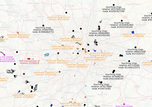
| Fixing multipolygons for the renderer | Last night I did a bunch of fixing, and as I look back at OSM inspector today, I can see that I succeeded in my aim, to fix all the pink errors in London (within the M25). This is satisfying.
…but among this sampling of multipolygon relations I think I noticed an another automated check we might do. I noticed some multipolygons which were created as two or more ways as ‘outer’ role, together forming a simple area, which was unnecessary and could be represented as a normal way. We should “simplify down” to a way in these cases. The criteria for this kind of “unnecessary” is possibly a bit complicated, but can be deteremined automatically. We’d need check none of the parts have other tags/memberships (or if they do have tags, they would need to all be the same tags). Also tricky things like tagging involving oneway directional ways might be a legitimate reason for splitting the area up into a multipolygon. Also if an multipolygon area has very many nodes (e.g. big lakes) then that’s a legitimate reason. But otherwise… it can be just a way, and it should just be a way. I wonder how many of these unnecessary multipolygons there would be. Maybe the map is totally littered with them. |