OpenStreetMap

IgnoredAmbience's Diary

Recent diary entries

Boundary Watch UK, issue 2

Posted by IgnoredAmbience on 9 February 2009 in English.

Since my last update at the end of December, the number of UK boundaries has grown quite impressively!

Of note is the NPE tracing of the Lincoln region by SK53, a very dedicated effort, although lacking the names in places.
Relations for the entirety of the counties of Somerset, Wiltshire and Devon by UniEagle.
And the addition of 5 parishes of Appleford, Culham, Harwell, Milton and Sutton Courtenay in Oxford by jochta.

I've been inactive on this front recently, but I'm going to go around the country doing a general tidyup where needed.

Boundaries

Posted by IgnoredAmbience on 21 December 2008 in English.

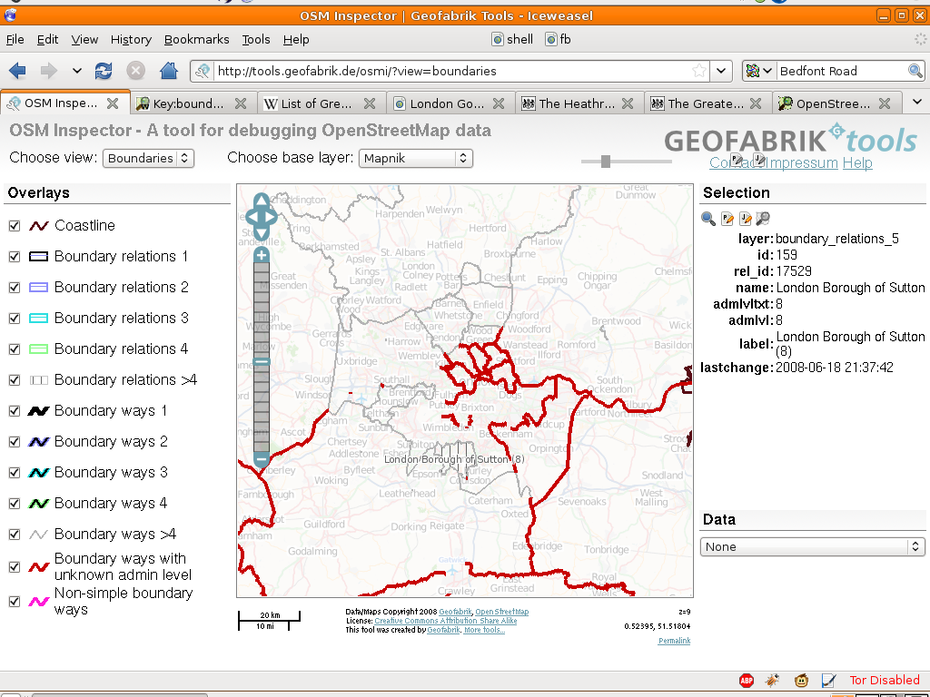
It is odd how rendering data makes people want to add it more. I've found this with the OSM Inspector boundaries layer.

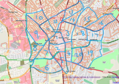
Take London for example, in mid-November, there were several boundary ways scattered across the capital, most with slightly differing tagging schemes. At this time, only my home borough, Sutton had an associating relation.

After a day's work, and a few minor fixes later, we arrived at a state where we had 10 boroughs fully complete and another 7 partially completed.

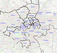
(#51908 is a 'container relation' for London boroughs, I'm guessing it may eventually morph into some form of is_in, if deemed useful)

More recently, I've made up the Hertfordshire boundary into a relation (the data was already mostly complete), and fixing the (very almost complete) attempt at getting Surrey done by chriscf.

He's also done up Wiltshire, Herefordshire, Shropshire, Rutland, and probably more.

And finally, this week I've been working on South Northamptonshire with Ben, tying together his excellent parish boundary tracings into relations, the OSMI view is now quite impressive, with around 30 of the 79 now complete!

I'm pleased to announce that the cake is ready for the 17th London Mapping Marathon party, this time in Croydon, South London.

Croydon has excellent transport connections to London via the fast mainline link from Victoria to East Croydon.

The pub to meetup in afterwards has not yet been decided, but keep an eye on the wikipage.

Hope to see you there!

Event Wikipage

Location: Broad Green, London Borough of Croydon, London, Greater London, England, CR0 2RL, United Kingdom

Uncreative Road Names

Posted by IgnoredAmbience on 20 June 2008 in English.

I like the namefinder, when looking for Carshalton Road, in Carshalton (one of several), it picked up several other Carshalton Roads elsewhere.

Location: Carshalton Beeches, London Borough of Sutton, London, Greater London, England, SM5 3LB, United Kingdom

OpenStreetMap in Geocaching
Greasemonkey is a brilliant plugin for Mozilla Firefox which allows you to run JavaScript snippets on loading certain webpages.
Using Greasemonkey, it is possible to embed OSM into other websites.

Several months ago, I originally started to embed Ordnance Survey maps into geocaching.com, since there was a reasonable demand for this functionality.
In the most recent version (after working on the OL codebase a little), I added OSM to the available layers for the map widget in an attempt to spread OSM's reputation among geocachers. The good news is that two people have already commented that they're surprised by OSM's coverage, and have started mapping their own data!

I gradually intend to push OSM further up the layer list and hopefully make it the default layer in future versions.

More activity

Posted by IgnoredAmbience on 25 October 2007 in English.

I've been mapping more of the area between Carshalton and Sutton this week, and I'm now nearing completion of this block. I've left the area of highest population density to last, as it will take the longest.

Talking in IRC yesterday, it was revealed that there's been a changes method in the API for around 2 weeks now, un-announced. Someone from the tiles@home project quickly managed to use it to seed the tile request list every few hours.
It's really great to finish mapping at 1am, go to bed, wake up and see your changes in the morning, without having to manually request them :)

Location: Benhilton, London Borough of Sutton, London, Greater London, England, SM1 3DA, United Kingdom

Idle

Posted by IgnoredAmbience on 21 September 2007 in English.

S'pose I'd better use this diary for once, I'll see if I can import it into my main blog sometime..

I've been idle for sometime, since school has restarted my time has been eaten up by schoolwork and other such boring things.

But, the times I did get to go mapping I mapped a nicely large swathe of Carshalton, Beddington and North Wallington. I'm now slowly moving westwards towards Sutton. When that area is done I'll move south again and tackle the south of the railway line in Wallington.

I also need to check the roads traced by the Beddington BedZed mapping party a few months ago - there's some roads missing from there, I think.

Annoyingly I tried using potlatch to map my school's buildings in a fairly high detail last week. Potlatch seems to have added 10 segments over each other in places due to upload errors. It took me a couple of hours to fix it all in JOSM.

Hope to get out mapping again soon.

Location: Wallington, London Borough of Sutton, London, Greater London, England, SM6 0LT, United Kingdom