PmaiIkeey's Diary Comments
Diary Comments added by PmaiIkeey
| Post | When | Comment |
|---|---|---|
| OSM issues apparently ? | It’s certainly a source of confusion - the label ‘trunk’. So it seems is the label ‘unclassified’. Both issues under the spotlight on relevant wiki talk pages. Taking the OSM definition of trunk - the A595 frequently falls well short to be in that classification. Mike. |
|
| OSM issues apparently ? | What is clear is the fact that whoever labelled the roads as ‘trunk’ has never used these roads. |
|
| OSM issues apparently ? | Having now read the wiki re OSM classification ‘Trunk’, the road does not fit this either “A high performance road” - since opposing vehicles have to stop in wide bits to allow other vehicles to crawl past - in various places. “single lane road.” It doesn’t even fit the botanical definition - since the road is around the peripheries of the country. |
|
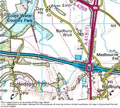
| OSM issues apparently ? | See: http://lonewalker.net/wp-content/uploads/imgres15.jpg for A419 (T) |
|
| OSM issues apparently ? | Well, they were denoted ‘roadnumber (T)’ on OS maps. Maybe OS have dropped this now ??? |
|
| OSM issues apparently ? | Rovastar - if you do your research properly, Trunk roads are those maintained by the Highway Agency rather than the Local Authority. The colour of road-signs has sod all to do with it. They are denoted on OS maps as: ‘Roadname (T)’ Please change them back and then do your research for the rest of the country to make sure those aren’t incorrectly labelled too. OH! I’ve done your research for you now, here: http://www.sabre-roads.org.uk/wiki/index.php?title=Trunk_road It even mentions the fact that your confusion is commonplace ! Please also note, I’m rarely wrong ! (but do feel free to keep me in check). Mike. |
|
| OSM issues apparently ? | Since when has “Londres” been the capital of England ? Cantorbéry in Kent ? Archipel de Saint-Kilda - off the NW coast of Scotland and my brother was def. not born in Lancastre ! Chrome Win8 - in Eng. UK ! I think splitting streets is a good way to show priorities by having the main roadname spanning the intersections - it adds info that otherwise doesn’t appear to appear - like speed limit changes. Such splits can improve the information available on the map. Similarly for footpaths - the map ought to show which are wheelchair-friendly. It’s all very well having it tagged as such but there’s little point if that’s not shown on the map. |
|
| OSM issues apparently ? | 3.4 - that’s useful to know ! It’s still in French ! http://umap.openstreetmap.fr/en/ is where I was looking and I suspect that’s a French site written in English showing French mapping. It’s looking like umap users are not selecting the correct language for their maps. http://umap.openstreetmap.fr/en/map/ideas-hive-projects-and-people_14384#11/54.7736/-1.5504 is a French-based map. |
|
| OSM issues apparently ? | umap.—.fr is in French - not surprisingly. WHY ? |