althio's Diary Comments
Diary Comments added by althio
| Post | When | Comment |
|---|---|---|
| Utiliser le guide iD | Tu peux ouvrir le panneau d’Aide (raccourci [H]), puis sélectionner la grosse icône. Et voilà ! 😀 Note : Par un lien direct, avant c’était possible avec c’est cassé en ce moment 🤕 https://github.com/openstreetmap/iD/issues/6484 |
|
| Useless data that only clutters the map and often geometrically wrong |
Not exactly: two crossing ways without a common node is perfectly acceptable, it is the proper modelisation in OSM for anything in different levels (eg. over and under a bridge). Further attributes (like explicit levels) are interesting but they are not going to help if the underlying topology is wrong. |
|
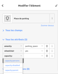
| parking handicapés | Effectivement, il faut ajouter un objet différent (un point ou polygone) de type “place de parking”. Ainsi le parking entier sera pourvu des attributs suivants :
et l’objet, plus petit, à l’intérieur du parking, pour les places PMR :
Les couleurs et les pictogrammes, ce sont les producteurs de carte qui décident comment représenter (ou non) une partie des données disponibles (tout afficher est impossible dans certaines zones). Parmi les cartes couramment utilisées, la version “française” a fait le choix d’afficher les pictogrammes pour les parkings spécifiques PMR. On peut donc le voir quand les données sont rechargées et les cartes rafraîchies. Mais c’est un tout autre et vaste sujet, que l’on peut lire et aborder sur le forum par exemple. |
|
| parking handicapés | en image :
|
|
| parking handicapés | Un parking tout entier est : amenity=parking https://wiki.openstreetmap.org/wiki/FR:Tag:amenity%3Dparking Sur cet objet, on indiquer de manière générale la possibilité de se garer pour tous et pour les places réservées : amenity=parking + capacity:disabled=yes/no/number + capacity:women=yes/no/number + capacity:parent=yes/no/number + capacity=number Des places de parking détaillées sont : amenity=parking_space https://wiki.openstreetmap.org/wiki/FR:Tag:amenity%3Dparking_space Si elles sont réservées aux personnes handicapées ou à mobilité réduite, on peut les cartographier (une par une ou en groupe de places) : amenity=parking_space + wheelchair=yes (voire d’autres options only/designated) + capacity:disabled=1 ou autre nombre |
|
| I-285 NOT a tunnel where the Hartsfield-Jackson runway bridge goes over | @Warin61 Your reading is rather selective. Alright about “surrounded by earth”: I can read and understand that and what it implies. But it seems that you forget much too easily ALL the context and other words, don’t you?
I agree with the current definition and others before: the “length” (length/width ratio) of the lower way is a interesting piece of information and it is natural to take it into account somehow. |
|
| I-285 NOT a tunnel where the Hartsfield-Jackson runway bridge goes over | @dygituljunky Surely a very similar situation happens in several places. Some other interesting cases:
I think tagging the way below (
|
|
| I-285 NOT a tunnel where the Hartsfield-Jackson runway bridge goes over | @Warin61
Nothing currently in https://wiki.openstreetmap.org/wiki/Key:bridge but https://wiki.openstreetmap.org/wiki/Key:tunnel reads:
And if you like “old” archives: - https://help.openstreetmap.org/questions/5934/bridge-vs-tunnel - https://wiki.openstreetmap.org/wiki/Talk:Key:bridge#Bridge_vs_Tunnels |
|
| Creating a National Highway Wall Map for Turkmenistan | @apm-wa You have a typo between Mapillary and Maperitive in this post. |
|
| 200th bus stop | Please find my attemps with Overview of OpenStreetMap Contributors aka Who’s around me?. Maybe you can remove the “Nonrecurring (<10 Changesets)” and try to contact some of the most active users through OSM messaging. http://resultmaps.neis-one.org/oooc?layers=B0TFFFFFT&zoom=13&lat=28.64304&lon=77.22342 http://resultmaps.neis-one.org/oooc?layers=B0FTFFFFT&zoom=13&lat=28.64304&lon=77.22342 http://resultmaps.neis-one.org/oooc?layers=B0FFFFFTT&zoom=13&lat=28.64304&lon=77.22342 |
|
| Mairies et églises de l'Aisne | Beau travail ! Il y a matière à présenter la méthode et les résultats sur d’autres pages : le forum, le wiki, le site de l’association française… Je suis sûr que d’autres pourraient s’y intéresser. |
|
| Mairies et églises de l'Aisne | Félicitations ! C’est un boulot effectué seul ou avec un groupe ? Avec une page de coordination ? |
|
| Je m'engage pour la bonne cause | Magnifique citation et toujours aussi actuelle :) |
|
| Identification | Sois la bienvenue. Je te souhaite de belles aventures avec OpenStreetMap, dans ton métier et dans tes relations. |
|
| Papanui Parallel - Christchurch Major Cycle Route |
It depends how often the data is pulled from OpenStreetMap database and processed in the routing engine. Typically updates for maps rendering is faster (sometimes seconds/minutes for very active projects) and updates for routing engine is slower (hours/days if active, weeks otherwise). So try again in a few days, Graphhopper, Mapzen bike, Brouter, … |
|
| Mapping the area of Le Thillot, Saint-Maurice-sur-Moselle and Bussang | You have an answer now on the France user forum.
|
|
| Numérisation | La question (un peu plus détaillée) peut être posée sur http://forum.openstreetmap.fr Sinon le wiki déjà mentionné ou plus condensé http://learnosm.org |
|
| Just Joined open street map. | Hi, You can see some users, who seems to be active: http://resultmaps.neis-one.org/oooc?zoom=15&lat=41.7475&lon=-74.0794&layers=B0TFFFFFT |
|
| OSM Awards–Decision Guidance | Some of your comments are interesting, your outright bias against humanitarian mapping aside. You “do not want to give [too much] of [your] votes to humanitarian mappers” is almost funny after reading your entire piece. Kudos for most of your analysis, I agree or at least respect your views most of the time. Some bits I do not understand or disagree:
Finally: “Why do the awards not have a system with rounds? During the first round, all mappers (people with OSM account) could suggest candidates and the descriptive texts”. Either I miss something obvious you are unhappy with… but this is exactly how the whole affair happened. Candidates were freely submitted by anyone with with an OSM account and you could even vote for a first round. As stated in the announcement of OSM Awards you quoted: https://lists.openstreetmap.org/pipermail/talk/2016-August/076533.html https://lists.openstreetmap.org/pipermail/osmf-talk/2016-August/003904.html |
|
| DEUX VERSIONS D'IMAGERIE SUR BING | Bonjour Saliou le contributeur “fou” du Bénin ! Tu es face à un problème bien gênant quand une imagerie est plus récente mais moins détaillée. Je crois que Sanderd17 et Vincent de Phily ont donné de très bonnes réponses qui te permettent d’utiliser la nouvelle imagerie en zoomant assez pour digitaliser avec JOSM comme à ton habitude. Même si la qualité est moindre, elle permet un très bon niveau de détail de cartographie pour les bâtiments. Leurs méthodes empêchent l’apparition de l’ancienne imagerie. J’ai une préférence pour la simplicité de la seconde solution mais les deux fonctionnent. Merci à eux ! J’ai testé sur ta zone pour un seul bâtiment que j’ai rajouté car il a été construit entre les deux imageries. https://www.openstreetmap.org/#map=19/10.484961/1.012587 Enfin n’hésite pas à venir sur les listes de diffusions par courriel où je pense que les contributeurs seraient plus nombreux à lire tes questions et commentaires. Par exemple la communauté francophone HOT : https://lists.openstreetmap.org/listinfo/hot-francophone Ou par forum de l’association française : http://forum.openstreetmap.fr/index.php A bientôt ! |