gvwaal's Diary
Recent diary entries
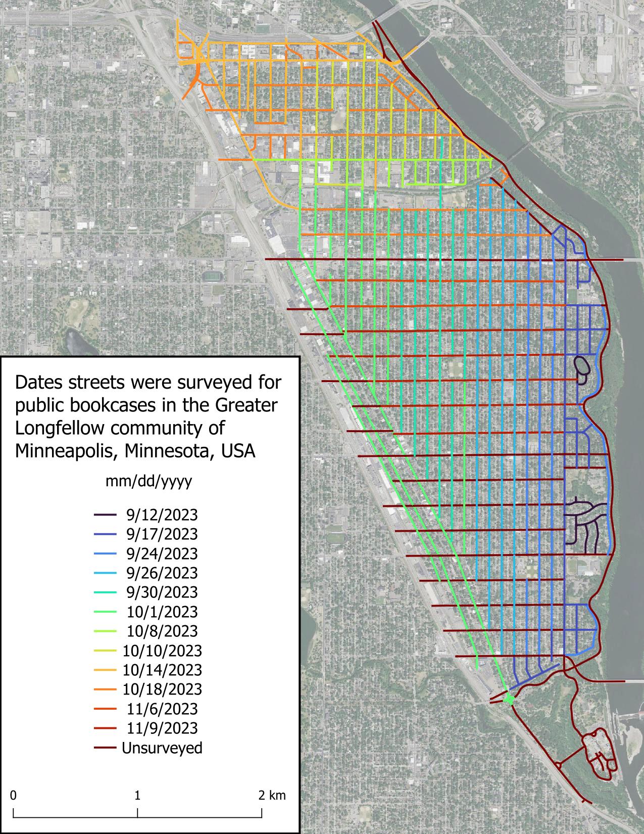
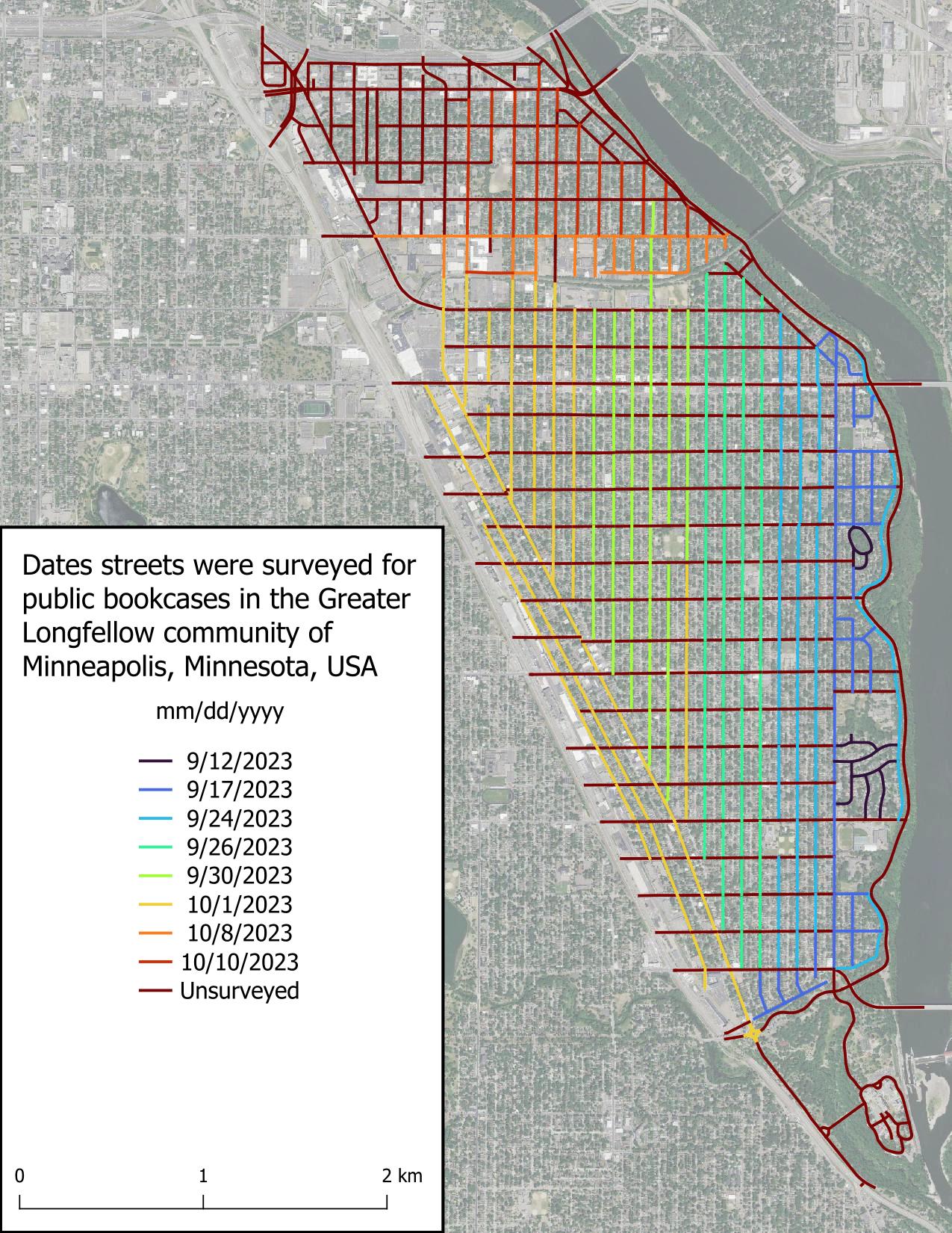
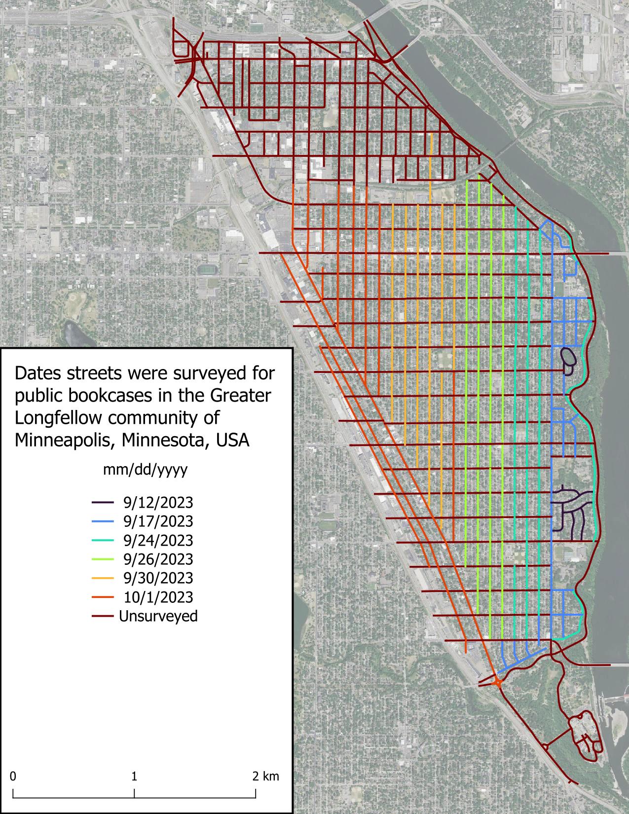
It is now cold out and also dark, which bodes poorly for finishing this project in a timely manner, because biking when it’s cold and dark isn’t fun. I was not able to achieve my goal of finishing this project by first snowfall (we got 1.8 in [4.6 cm] on Oct 31), but I’m not taking this to heart because a lot of my time the past several weeks has been spent with higher priority things.
Today I was able to finish two streets in about 30 minutes, which is great! These were some of the longer streets in Greater Longfellow, so the pace will be quicker from here on out, most likely due to there being less clutter obstructing my view.
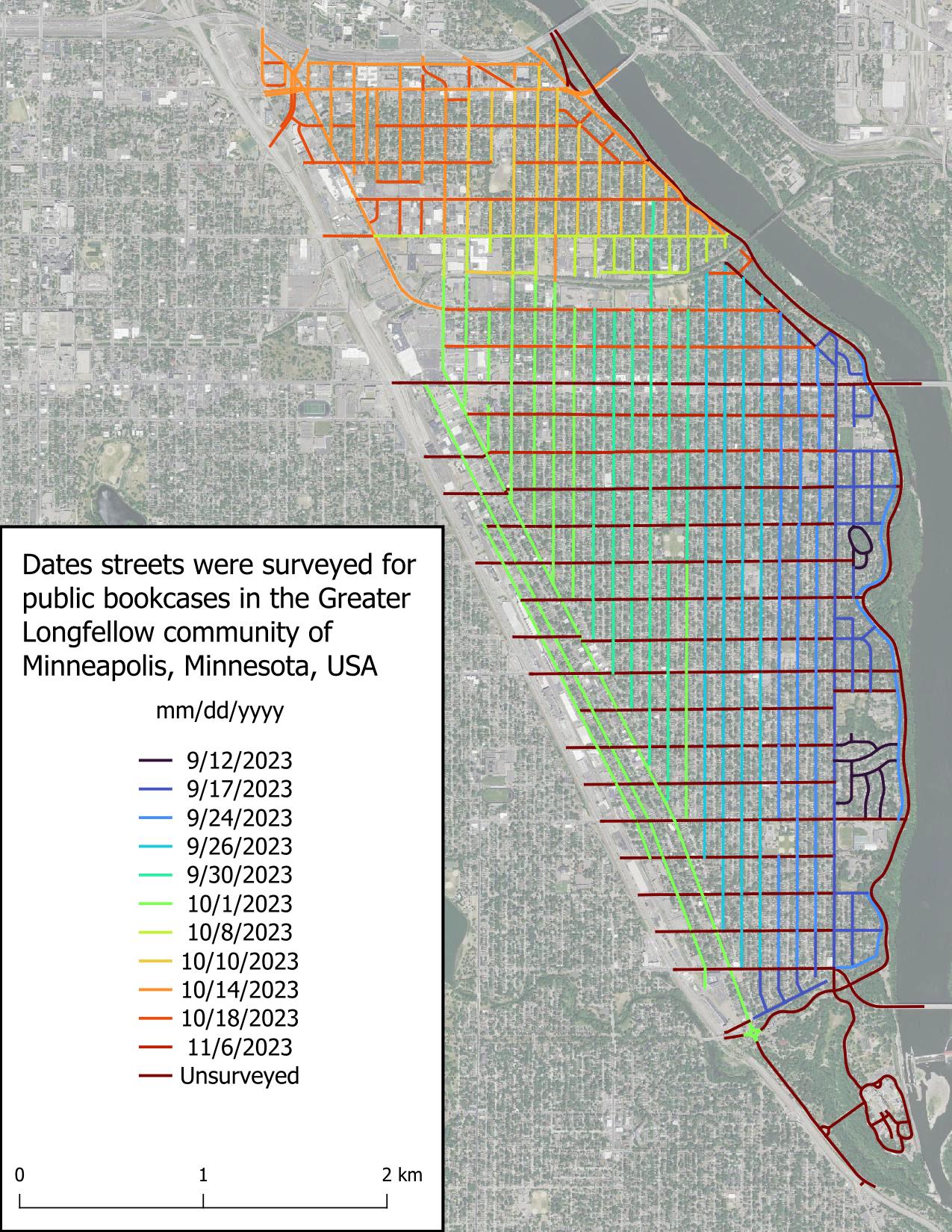
All* of Seward is surveyed! I found very few public bookcases (PBs) when surveying the remaining streets, which wasn’t surprising because most people put their PB in their front yard, and in Minneapolis, most front yards are on the avenues (north-south roads).
*It’s possible there are PBs in the entryways or at the base of large apartment complexes, and I didn’t attempt to circumnavigate each large apartment as that would have involved leaving the street.
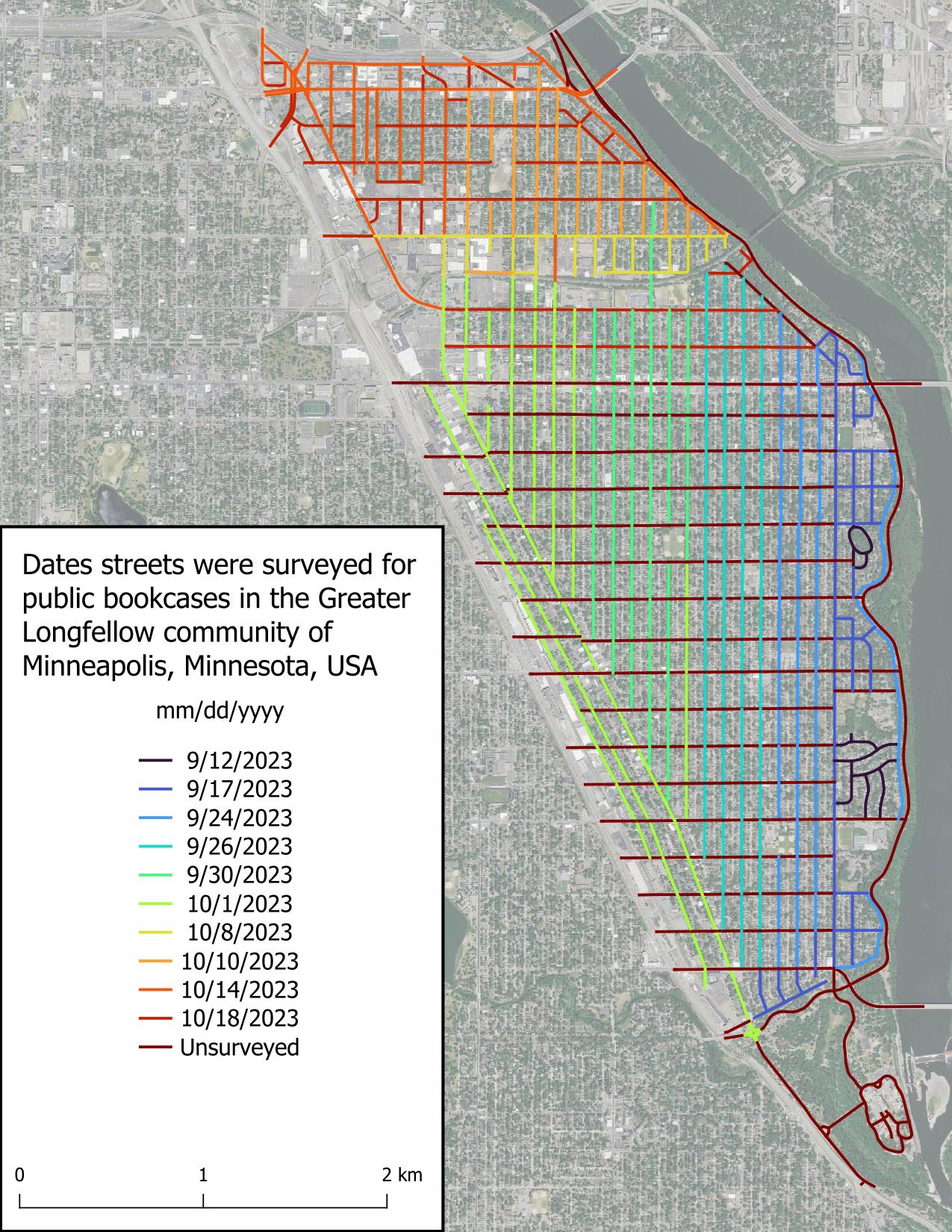
I surveyed most of Seward’s avenues today, but what I’m most excited about is having finished surveying the three streets I was least excited about (9th St S, Franklin Ave E, and Minnehaha Ave S), leaving calmer streets for the rest of the project.
Unsurprisingly, I found few public bookcases (PBs) today. I believe this is due to the non-single family home nature of the roads surveyed, and in the roads lined with single family homes, the economic conditions of the inhabitants.
Shoutout to the Feminist Book Club for being the only non-residential entity (witnessed so far) to host a PB.
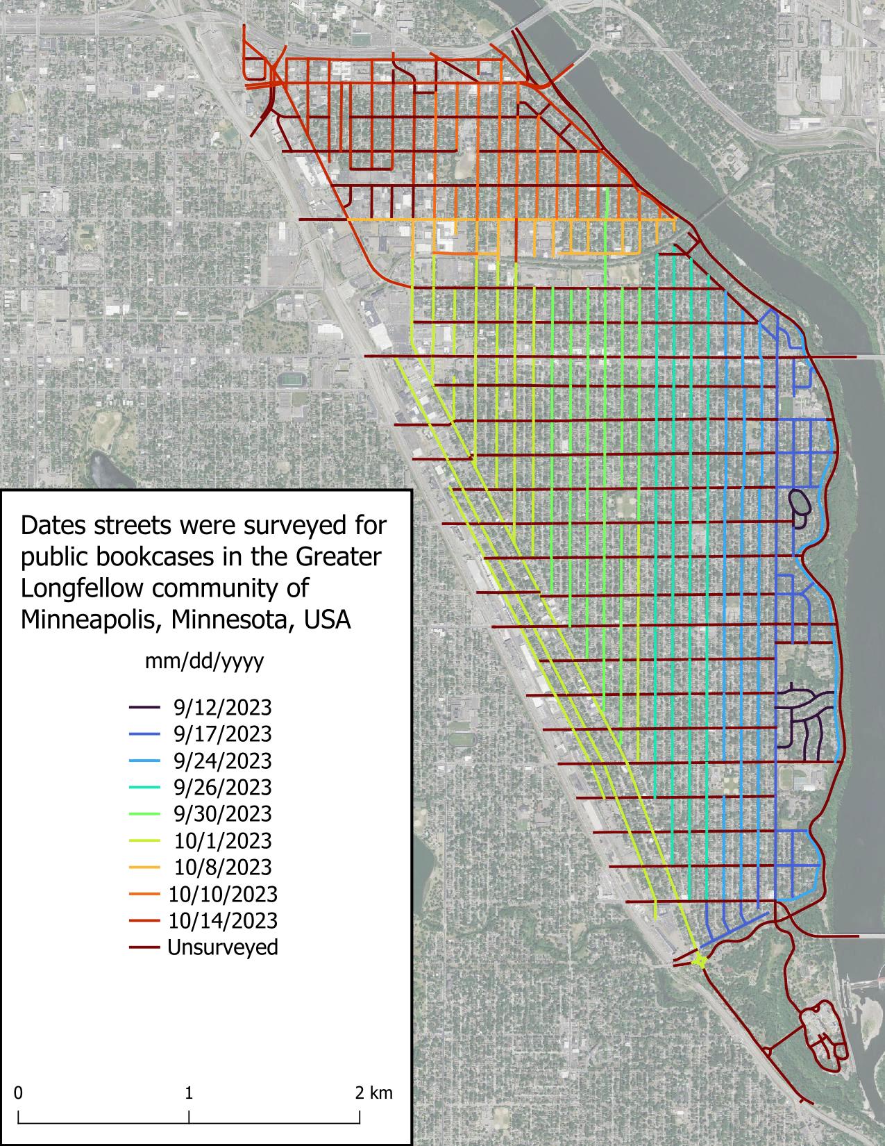
I really thought I was going to be able to survey all of the Seward neighborhood today, but it got dark more quickly than expected. That really hampers my ability to see public bookcases, as you’d expect. Good to know for future surveys. It’s a solid start.
The weather has become substantially chillier than September and that’s really impacting my motivation. I wanted to wrap up this project before the first snow, but I’m wondering if my expectations were too high. Time will tell.
I really appreciate the kind words folks have left on my previous diary entry. I didn’t expect to get any acknowledgement, which is fine, but people left comments yesterday, over a week after I posted it. What a nice community OSM has!
Mapping public bookcases
Posted by gvwaal on 2 October 2023 in English. Last updated on 10 November 2023.I enjoy reading people’s diary entries, so I’m starting my own. My current project is mapping public bookcases (PBs) in neighborhoods near me.
I started this project because I chance upon PBs when going for walks and can never remember where a PB is when I need one. There’s a map of Little Free Libraries (LFLs), but adding PBs to this map is “pay to play” which I don’t like, in addition to not displaying unaffiliated PBs. Other secondary goals include:
- having fun exploring my surroundings
- analyzing the distribution of LFLs vs. unaffiliated PBs (because registering your PB as an LFL costs a minimum of $40 USD)
- identifying areas of high and low concentrations of PBs
- identifying streets with high and low numbers of PBs
- exercising in an engaging way
- identifying whether the concentrations of PBs correspond to particular demographics
- identifying whether the locations of PBs are correlated with particular types of land use
- bragging rights: how many people can say they biked 150km and contributed to the betterment of humanity in doing so?
Scope
I’m limiting my survey to the Greater Longfellow community of Minneapolis, comprised of the neighborhoods of Cooper, Hiawatha, Howe, Longfellow, and Seward. This area was chosen because they’re easily accessible by bike. Only roads that likely would host a PB are to be surveyed, such as residential roads or commercial roads adjacent residential areas.
Tools
- Bicycle: transportation
- Smartphone with the Vespucci app: mapping
- High resolution leaf-off true color aerial imagery: mapping reference
- QGIS: figure creation and data tracking
Methodology
Starting with avenues (roads going north to south), I bike down the middle of the road at 5-10mph visually scanning for PBs. When a PB is identified, I stop on the side of the road near the PB and log its location in Vespucci. For busy or wide roads, like Minnehaha Ave S or Lake St E, I bike down one side of the street, then back up the other side of the street once I reach the end. This process is repeated for the whole avenue, then for all avenues in the scope area, and then for all the streets (roads going east to west). Any PB with a LFL charter sign is tagged with brand=Little Free Library. No other tags are included.
Sources of error and attempted mitigation
- Eye fatigue: I occasionally felt my eyes disengaging after an extended duration of surveying. However, I also noticed my eyes gravitated to PBs once I came near them on the road, which makes sense, because they really stand out from their surroundings unless obstructed.
- Visual obstructions (vegetation, autos, sun glare, etc.): Autos commonly obstructed my view of the boulevards containing PBs, but I found that I was generally tall enough to see over most autos, and when I wasn’t, that looking back over my shoulder when passing the obstruction was enough to confirm whether a PB was present. Vegetation dense enough to obscure PBs was uncommon, but when present, slowing down or looking back over my shoulder was sufficient mitigation.
- Absentmindedness: During periods of extended surveying, I sometimes noticed I had no memory of the past several minutes of surveying. To ensure I didn’t miss anything, I surveyed the road again.
- Distractions: Roads with consistent auto traffic, like Minnehaha Ave S, made surveying busy roads challenging, since keeping aware of traffic took away brainspace that could have been used to check for PBs. Both slowing my velocity and surveying one side of a road at a time helped mitigate distractions.