OpenStreetMap

ivanbranco's Diary

Recent diary entries

Mapping trees

Posted by ivanbranco on 28 April 2024 in English.

[Semi-automated translation of the Italian diary entry]

On OpenStreetMap, a tree can be represented as a natural=tree node.

Leaf type 🌿

leaf_type is the most common tree-related tag in the database, this is because it is easily verifiable and is supported with a quest by StreetComplete. The values are broadleaved and needleleaved. Some argue that palms should not be tagged as broadleaved but with a value of their own, =palm.

Leaf cycle 🍂

This tag describes whether a tree is deciduous or evergreen. Most needleleaved tree species are evergreen, but this is not always the case, so do not infer this value automatically. You can add this value easily if you know the species, or more simply if it is autumn/winter. If not, you can try to see if satellite or street-level imagery taken at those times are available.

Genus and species 🌳

If you are not an expert, there are tools that can help you recognise the genus/species of a plant, such as Pl@ntNet and iNaturalist, both of which also exist as mobile apps. On OpenStreetMap there are many trees with species (or species:wikidata or species:xx) that do not have leaf_type or leaf_cycle. These values are of course identical for each species (and also for many genus) and can therefore be easily deduced. There are two lists on the OSM wiki that contain these values for genus and species.

MapComplete has a dedicated tree theme that can be used to enter the species while SCEE has a dedicated quest (“What is the genus or species of this tree?”).

Monumental trees 🏛️

Monumental trees can be mapped adding denotation=natural_monument. In Italy they are recorded by the Ministry of Agriculture, Food Sovereignty and Forests (Masaf) with annual updates. You can map them by adding ref:masaf, which is a unique code assigned by the ministry.
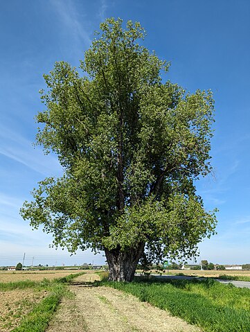
The Black Poplar of Tronzano Vercellese

In Poland they are recorded by the ‘Generalna Dyrekcja Ochrony Środowiska’ (GDOŚ) (you can find many of them with a query natural=tree+ref:inspire=*), in Serbia many zapis (sacred trees) are mapped with ref:zapis while b-unicycling has recently documented the place_of_worship=sacred_tree tag to map rag trees in Ireland and Scotland.

Rendering 🎨

Trees are rendered on Carto as green circles with a brown dot in their centre, regardless of their attributes. Rendering of Carto trees

The Straßenraumkarte Neukölln renderer shows the trees differently according to leaf_type, circumference and diameter_crown. However, the web map only works for the Berlin district of the same name.

F4 Map and Streets GL (no longer updated) are 3D renderers that use the height tag. F4 Map distinguishes trees by foliage type and also supports some values to differentiate palm trees. Esri also has a 3D map that uses OSM data, and which should support height and also some genus values.

On the IMAGICO.De blog, there is an interesting article that goes into detail on possible renderings to highlight the various attributes.
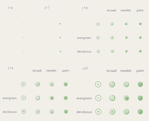
QA 🛠️

There are more than 20,000 mapped trees, but QA tools are still few. That is why I created this MapRoulette project: Tree Validation.

There are challenges that compare values in the database with the largest values ever recorded in nature, for example trees taller than Hyperion. Other challenges concern uncommon or incorrect values of denotation, species, genus, leaf_cycle or leaf_type.

The hope is that in the future more and more tools will check on tree tagging. For now there is at least one open issue for Name Suggestion Index and one for Osmose/JOSM.

If you want to discuss trees on OSM, you can use the “tree” tag on the OpenStreetMap Community Forum.

Have fun mapping!

Mappare gli alberi

Posted by ivanbranco on 28 April 2024 in Italian (Italiano).

Su OpenStreetMap, un albero può essere rappresentato come un nodo natural=tree.

Leaf type 🌿

leaf_type é il tag maggiormente valorizzato nel database, questo perché é facilmente rilevabile (basta un’occhiata) ed é supportato con un’apposita quest da StreetComplete. I valori sono broadleaved (latifoglia) e needleleaved (aghifoglia). C’é chi sostiene che le palme non debbano essere taggate come latifoglia ma con un valore tutto loro, =palm.

Leaf cycle 🍂

Questo tag descrive la caduta fogliare, cioè se un albero é caducifoglio o sempreverde. La maggior parte delle specie di alberi aghifoglia sono sempreverdi, ma non é sempre così, non inferite quindi questo valore automaticamente. Questo tag é facilmente compilabile se conoscete la specie, o più semplicemente se é autunno/inverno. In caso contrario potete provare a vedere se sono disponibili immagini satellitari o foto a livello stradale scattate in quei periodi.

Genus e species 🌳

Se non siete esperti, esistono degli strumenti che possono aiutarvi a riconoscere il genere/specie di una pianta, come Pl@ntNet e iNaturalist, entrambi esistono anche come app mobile. Su OpenStreetMap esistono moltissimi alberi con species (o species:wikidata o species:xx) che non hanno leaf_type o leaf_cycle. Questi valori sono ovviamente identici per ogni specie (e anche per molti generi) e quindi possono essere facilmente deducibili. Sulla wiki di OSM esistono due liste che contengono questi valori per genere e specie.

MapComplete ha un tema dedicato agli alberi che può essere utilizzato per inserire la specie mentre SCEE ha una quest dedicata (“What is the genus or species of this tree?”).

Alberi monumentali 🏛️

Il Ministero dell’agricoltura, della sovranità alimentare e delle foreste (Masaf) ha censito (con aggiornamenti annuali) gli alberi monumentali d’Italia. Potete mapparli aggiungendo loro il tag denotation=natural_monument e ref:masaf. Quest’ultimo é un codice univoco assegnato dal ministero.

Il Pioppo Nero di Tronzano Vercellese

Solitamente un albero monumentale dovrebbe avere tutti i seguenti tag valorizzati: ele,species,species:wikidata,height,circumference,leaf_type e leaf_cycle. Questa query Overpass mostra gli alberi monumentali mappati al momento ed evidenzia quelli il cui tagging potrebbe essere migliorato: link

All’estero anche la “Generalna Dyrekcja Ochrony Środowiska” (GDOŚ) in Polonia censisce gli alberi monumentali (potete trovarne molti con una query natural=tree+ref:inspire=*), in Serbia molti zapis (alberi sacri) sono mappati con ref:zapis mentre b-unicycling ha recentemente documentato il tag place_of_worship=sacred_tree per mappare i rag tree in Irlanda e Scozia.

Rendering 🎨

Gli alberi sono renderizzati su Carto come dei cerchietti verdi con un puntino marrone al loro centro, a prescindere dai loro attributi. Rendering degli alberi di Carto

Il renderer Straßenraumkarte Neukölln mostra gli alberi in modo differente in base a leaf_type, circumference e diameter_crown. La web map funziona però solo per l’omonimo quartiere di Berlino.

F4 Map e Streets GL (non più aggiornato) sono renderer 3D che utilizzano height per visualizzare l’altezza degli alberi. F4 Map distingue gli alberi per tipo di fogliame e supporta anche alcuni valori per differenziare le palme. Anche Esri ha una 3D map che utilizza dati OSM, e che dovrebbe supportare height e anche alcuni valori di genus.

Sul blog di IMAGICO.De esiste un interessante articolo che approfondisce possibili rendering per evidenziare i vari attributi.

QA 🛠️

Esistono più di 20.000 alberi mappati, ma gli strumenti di QA rimangono ancora pochi. Per questo motivo ho creato questo progetto MapRoulette: Tree Validation.

Ci sono challenge che confrontano i valori nel database con i valori più grandi mai registrati in natura, ad esempio alberi più alti di Hyperion. Altre sfide riguardano valori poco comuni o errati di denotation, species, genus, leaf_cycle o leaf_type.

La speranza é che in futuro sempre più tool proporranno check di vario genere sugli alberi. Per ora esiste almeno una issue aperta per il Name Suggestion Index e una per Osmose/JOSM.

Se volete discutere di alberi su OSM, potete utilizzare il tag “tree” sull’OpenStreetMap Community Forum.

Buon mapping!

My favourite OSM tools v.1.5

Posted by ivanbranco on 28 April 2023 in English.

I am sharing some of my favourite OSM-related tools/websites/apps with a very brief description, including the most popular ones (you never know). I’ve certainly forgotten many of them and don’t know as many.

Italian version

Websites

  • overpass turbo: Fundamental website for database queries. Also useful for custom QA filters.
  • taginfo: Check which tags are most used, their usage over time, the most used values for each tag etc. For the history of a tag there is also this site.
  • RapiD: iD on steroids. Reports possible missing buildings and streets.
  • osm-revert: Revert entire changesets (it replaced Revert UI which is no longer supported).
  • Level0: Revert individual nodes. It is also a useful text editor for changing several tags at once. However, read this first.
  • NotesReview: Filter OSM notes by user, date, text etc. There is also a site by Pascal Neis.
  • Disaster Ninja: Not its main purpose, but there is an interesting layer called ‘Building Quantity’ in case you want to find areas with unmapped buildings.
  • YoHours: To simplify the compilation of the opening_hours=* tag.
  • How Did You Contribute: Stats about users. There’s also your changes’ heat map.
  • Is OSM up-to-date?: Interesting site created by an Italian that tells you which nodes are less up-to-date. If there is nothing to update you can still leave a check_date tag.
  • Field Papers: Edit OSM by taking notes on paper.

Renderer

Wiki

  • OSM Wikidata: Match Wikidata pages and OSM elements. There is an updated version that I prefer, but it is still in beta and doesn’t always work.
  • WikiMap: Search for images to add as a value of wikimedia_commons=*. There is also WikiShootMe! which also includes Flickr images with compatible licences.
  • Wikimedia Commons App: Has two interesting features: it allows uploading from mobile and has a map showing Wikidata entries without pictures.
  • OpenStreetBrowser: Using the “OpenStreetMap Quality Control > Culture-Media/Wikidata” filter you can see a map of the entries without photos. It is more comprehensive than the Commons app because it includes items of interest (e.g. memorials) regardless of their presence on Wikidata.
  • OSM-wikipedia-tag-validator-reports: Correct problems with wiki tags.

QA

  • Osmose: The QA site par excellence.
  • OSMCha: The perfect site for gardening. Easily see changes in a given area, by user, etc.
  • WhoDidIt: You know when someone edits a bar in Caracas and a restaurant in Osaka and OSMCha notifies you even if nothing was changed in your area? This website fixes this.
  • OSM Latest Keys: The new tags that appeared in the OSM database. 90% of the time they are typo, errors or tags with alternatives already in use.
  • Find Suspicious OSM Changeset: Find changesets of new users who have requested a review. They rarely receive feedback. It would be nice if experienced users would comment at least one changeset every now and then, even only for welcoming them (there is also a dedicated tool: OpenStreetMap Welcome Tool).
  • OSM Inspector

Mobile apps

  • OsmAnd: OSM in your pocket. Offline maps everywhere, indispensable for trekking. Also useful in urban environments to find drinking fountains, litter bins and free parking spaces.
  • StreetComplete: For quick gamification-style changes.
  • EveryDoor: Good for checking which shops are up to date and for micro-mapping.
  • OSMBugs: Reports from various QA platforms at your fingertips.
  • Waze: Car navigator that you can evaluate as an alternative to Google Maps.
  • Organic Maps and MAPS.ME: Like OSMand, but more user-friendly. To be recommended to less experienced relatives and friends. Some prefer Mapy.cz.

I miei progetti

Posted by ivanbranco on 19 July 2022 in Italian (Italiano). Last updated on 12 November 2023.

Alcuni dei progetti che porto avanti:

MapRoulette

I miei tool OSM preferiti v.1.5

Posted by ivanbranco on 8 July 2022 in Italian (Italiano). Last updated on 28 April 2023.

Condivido alcuni dei miei tool/siti/app preferiti relativi ad OSM con una brevissima descrizione, compresi quelli più conosciuti (non si sa mai). Sicuramente ne ho dimenticati molti e non ne conosco altrettanti.

Siti

  • overpass turbo: Sito essenziale per fare query sul database. Utile anche per fare filtri QA personalizzati.
  • taginfo: Per controllare quali tag sono più utilizzati, il loro uso nel tempo, i valori più utilizzati per ogni tag ecc. Per la history di un tag esiste anche questo sito.
  • RapiD: iD sotto steroidi. Segnala possibili edifici e strade mancanti.
  • osm-revert: Per revertare interi changeset. (ho sostituito Revert UI, non più supportato).
  • Level0: Per revertare singoli nodi. È un editor testuale utile anche per cambiare svariati tag contemporaneamente. Leggete però questo prima.
  • NotesReview: Per filtrare le note di OSM per utente, data, testo ecc. C’è anche un sito di Pascal Neis.
  • Strade senza nome
  • Disaster Ninja: Non è il suo scopo principale, ma c’è un layer interessante chiamato “Building Quantity” nel caso vogliate trovare zone con edifici da mappare.
  • YoHours: Un sito per semplificare la compilazione del tag opening_hours=*
  • How Did You Contribute: Statistiche riguardanti gli utenti. C’è anche la heat map delle vostre modifiche.
  • Is OSM up-to-date?: Interessante sito creato da un italiano che vi segnala i nodi meno aggiornati. Se non c’è nulla da aggiornare potete comunque lasciare un tag check_date.
  • Field Papers: Modificate OSM prendendo appunti su carta.

Renderer

Wiki

  • OSM Wikidata: Per trovare collegamenti tra pagine Wikidata ed elementi OSM. Esiste una versione aggiornata che preferisco ma è ancora in beta e un po’ ballerina a volte.
  • WikiMap: Per cercare immagini da aggiungere come value di wikimedia_commons=*. Esiste anche WikiShootMe! che comprende anche immagini Flickr con licenze compatibili.
  • Wikimedia Commons App: Ha due feature interessanti, permette di fare upload da mobile e ha una mappa che mostra le entry Wikidata che non hanno ancora una foto.
  • OpenStreetBrowser: Andando in “OpenStreetMap Quality Control > Culture-Media/Wikidata” potete vedere una mappa degli elementi senza foto. È più completo dell’app di Commons perché comprende gli elementi di interesse (es. memoriali) a prescindere dalla presenza su Wikidata.
  • OSM-wikipedia-tag-validator-reports: Un validatore per correggere problemi relativi ai tag wiki.

QA

  • Osmose: Il sito QA per eccellenza.
  • OSMCha: Il sito perfetto per fare giardinaggio. Per vedere facilmente le modifiche in una data area, per utente ecc.
  • WhoDidIt: Hai presente quando qualcuno modifica un bar a Caracas e un ristorante a Osaka e OSMCha ti segnala il changeset anche se nulla è stato modificato nella tua area? Questo sito risolve questo problema.
  • OSM Latest Keys: I nuovi tag apparsi nel database di OSM. Il 90% delle volte sono typo, errori o tag che hanno alternative già in uso.
  • Find Suspicious OSM Changeset: Con questo filtro trovate i changeset di nuovi utenti che hanno richiesto una review. Quasi sempre non ricevono feedback. Sarebbe bello se gli utenti più esperti commentassero almeno un changeset ogni tanto, anche soltanto per dargli il benvenuto (esiste anche un tool dedicato: OpenStreetMap Welcome Tool).
  • OSM Inspector

Apps mobile

  • OsmAnd: OSM in tasca. Mappe offline ovunque, indispensabile per il trekking. Utile anche in ambiente urbano per trovare fontanelle, cestini e parcheggi gratuiti.
  • StreetComplete: Per effettuare modifiche in modo veloce in stile gamification.
  • EveryDoor: Ottimo per verificare che i negozi siano aggiornati e per il micromapping.
  • OSMBugs: Le segnalazioni di svariate piattaforme QA a portata di mano.
  • Waze: Navigatore auto che potete valutare in alternativa a Google Maps.
  • Organic Maps e MAPS.ME: Come OSMand, ma più user-friendly. Da consigliare a parenti e amici meno navigati. Qualcuno preferisce Mapy.cz.

Changelog:

v.1.1 Aggiunto Mapy.cz, Wikimedia Commons App e OpenStreetBrowser. Aggiunta sezione “Wiki”.

v.1.2 Aggiunto OSM Buildings. Aggiunta sezione “Renderer”.

v.1.3 Aggiunto OpenStreetMap Welcome Tool e OSM-wikipedia-tag-validator-reports.

v.1.4 Aggiunto Field Papers

v.1.5 Aggiunto WhoDidIt, EveryDoor e osm-revert. Modificato WikiShootMe!.