miroslavuzice87
- Mapper since:
- September 21, 2016
Hi everyone :-)
I am proud to be in the Microsoft Open Maps team and to help in making better maps. Our team uses the hashtag #MSFTOpenMaps for our edits. For more information about Microsoft Open Maps work please visit our Wiki or GitHub page.
The Open Maps team at Microsoft is a small team working to improve the data quality for OpenStreetMap. We are not making bulk edits, automated imports or algorithmic ‘robot’ edits into OSM anywhere. Our goal is to improve OpenStreetMap. Our team primarily uses JOSM for editing. We use our own internal instance of Tasking Manager to organize some aspects of our work, but primarily use Map roulette for organized activities. We use many of the data sources that are publicly available to all OSM mappers as JOSM layers. We use public instances of OSM QA tools such as Osmose, KeepRight, OSMCha.
Here are some examples of features we commonly focus on: turn restrictions, signposts, lanes and turn lanes, boundaries, new roads, road names, one-ways, traffic signals, natural features. *This is not an exhaustive list.
Useful links related to my work, such as: “How did you contribute to OpenStreetMap?”; “Missing Maps Badges”; “Your OSM Heat Map”; “Mapillary”:
OSM Microsoft - organised map edit
OSM HDYCmap - my map contribute
OSM MMapper - missing map badge
OSM Heat Map - my all edits on map
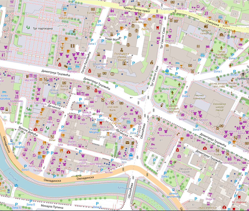
OSM UziceMap - most proud project
OSM Mapillary - street_level imagery
OSM WikiPage - personal wiki page
https://wiki.openstreetmap.org/wiki/Micromapping is a huge deal for me, I just love all the details u can enter into the map. Micro mapping or micro-mapping in OpenStreetMap (OSM) refers to the mapping of small-scale features. This may include mapping such objects as a building entrance, as well as the footway and steps leading to that entrance. Another aspect is to improve the visual representation of scenery for 3D for example. Therefore this includes improving geometries (buildings, land use, …) but also adding very small objects such as city furniture (street lamps, benches, …) and village green (trees, hedges, …)
Pros and cons of micro mapping;
Pros:
- allows 2D routing
- helps in indoor positioning systems
- brings a lot of details to the DB
- If done properly it will ease mapping in previously empty regions
Cons:
- more time consuming to enter data for mappers
- requires more accurate information (sometimes consumer GPS is not sufficient)
- sometimes makes it harder for beginners to alter the data
- If it is required in some proposals on osm wiki, it may discourage people from using it (technical) increase of volume will increase requirements in processing power
Click on image bellow to see detailed map of Uzice in OSM: