OpenStreetMap

poppei82's Diary

Recent diary entries

Wiki loves monuments - OpenStreetMap, too!

Posted by poppei82 on 8 September 2014 in English. Last updated on 9 September 2014.

Hi,

From 1.9. until 30.9. Wikimedia wants to collect nice pictures of cultural heritage. With the Wiki Loves Monuments contest you can win nice prices if your photos show a cultural heritage (building, monument etc.).

But if you go outside, don’t forget OpenStreetMap:

  • it will support you in finding the cultural heritage monuments
  • you can also add the cultural heritage monuments into the OSM-database

Find cultural heritage

You find the cultural heritage in your local city by browsing the country-specific lists of cultural heritages. For example in the overview of Germany’s cultural heritage lists you can navigate to the cultural heritage list of the city where you want to go to take pictures.

An online Graphic User Interface you’ll find at the Wiki Loves Monuments Map. However the monument lists for Germany are not complete. It seems that they were not found automatically by the Monuments Database-bot. Also there is no possibility to download GPX. Another tool, Panoramap seems to be outdated? I couldn’t see anything on it.

Planning routes (with Univisited or WLM-app (Android))

There is a small Android App that will support you in planning routes: Unvisited. You can set how many kilometres you want to go and how many pictures you want to take. It has a special “Wiki Loves Monuments-mode” that will specially look for cultural heritage. You can also take pictures for other Wikipedia articles. This app only shows locations of articles/monuments where a picture is still missing! However this app uses G-Maps and it is not possible to navigate directly to the monuments.

The Wiki Loves Monuments App is the official app to browse monuments, taking pictures and uploading them directly. However I was not able to do anything with this app…

GPX-export and navigation to monuments + taking pictures (with Osmand (Android))

If you want to do a biketour and take pictures you possibly already use the free and offline usable Osmand for Android smartphones. I will show you how to import cultural heritages and how to navigate to them. As an example I will describe the following steps for Bad Sobernheim, a small town in Rhineland-Palatinate/Germany.

  1. Open list of cultural heritages for your city, e. g. Bad Sobernheim
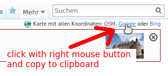
  2. Click on “Google” link with right mouse button and copy the link to your clipboard. For German Wikipedia in the upper right corner: KML-Export in English Wikipedia
    and for English Wikipedia near the References-header. Click on “show” where you find the direct download-link to gpx-file (you can go to step 5): KML-Export in English Wikipedia
    Other Wikipedias: If your Wikipedia has no links in the upper right corner, you can use kmlexport directly. You have to define the project language (NL, DE, CS, EN, …) and the article-name. Syntax: https://tools.wmflabs.org/kmlexport?project=LANGUAGE&article=NAME_OF_ARTICLE. See example in the comments.
  3. a) Open a new tab or window in your browser and insert the copied link. Delete “&redir=google” from adress and hit Enter. The kml-File will be downloaded. Rename the file to XYZ.kml
    b) You can use KML to GPX converter, where you can directly paste the downloadlink for kml-file. An Osmand-GPX-file will be downloaded. You can go to step 5.
    PLEASE NOTE: This downloads ALL knowing locations of monuments! I don’t know how to download locations of missing pictures ONLY. The mentioned Unvisited-App is doing so but I do not know how to download this gpx. Any hints?
  4. Since version 1.8 of Osmand it should be possible to import kml-files directly However in my test it wasn’t possible. So maybe it is necessary to convert the kml-File into a gpx-File. You can use e. g. KML2GPX online tool or the converter mentioned in 3 b) for this purpose.
  5. Copy the kml- and/or gpx-File to your smartphone and open it with Osmand. Perhaps you need a file manager to find the file on your phone.
  6. You will see the monuments as an overlay on the Osmand-Map. If you have never used Osmand before, you should download the map for your country first. Tap on a red position marker for about one second, then additional information will appear on the screen (name of the monument as it was in the Wikipedia-table). 
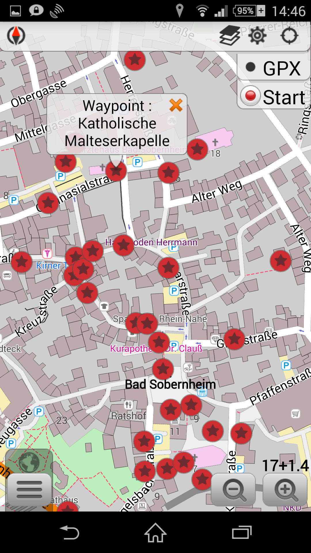
Tap shortly on this information, then a menu appears where you can navigate directly to the monument or taking a picture.
  7. You find the pictures in your osmand-directory on your phone in the subdirectory “avnotes”. You have to rename them properly and upload them to Wiki commons using the WLM-Upload-agent or the Wikimedia Commons App

Mapping monuments for Historical Map

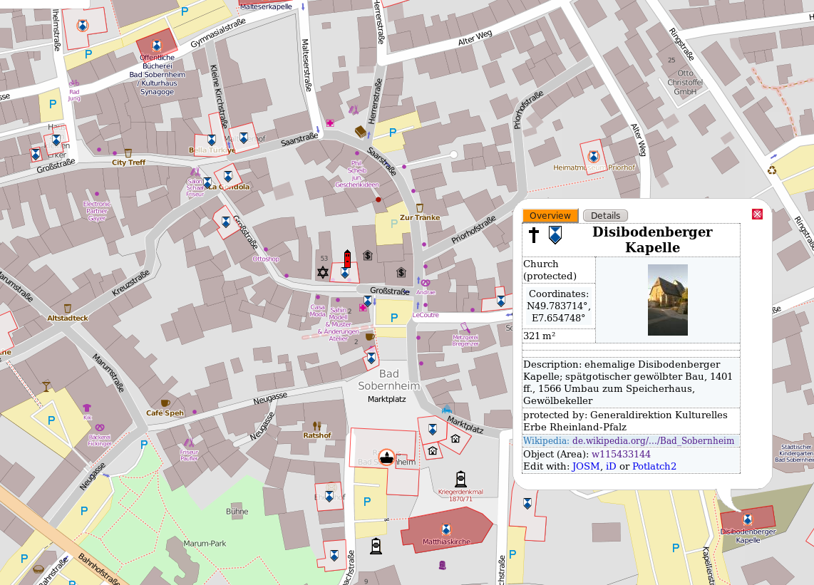
After your visit of the cultural heritage monument you have local knowledge that you can also contribute to the OpenStreetMap database (perhaps you also did a gps-track using Osmand). Then this heritage-object will appear on the great Map of Historical Objects.

You find the explanation on how to map Historical Objects on the Wiki-page. Keep in mind that there is a nice JOSM-preset with which it is very easy to map such objects. With the optional Heritage-Preset you can add additional heritage-specific information on the objects.

PLEASE NOTE: Only map objects that are listed in the cultural heritage lists, please. Do not map any monuments which are not of heritage importance.
PLEASE NOTE: if applicable, add the Wikidata, WikiCommons or Wikipedia-links. See comments.

Wishes for the future

You see that it is a little bit complicated to combine the two great open projects: driving around to do some mapping and parallely saving the cultural heritage for the upcoming generations. In my eyes it is a waste of the crowds’ power if only one thing is done though an open minded human is once a time on a place and wants to contribute to both projects.

So I think we need a little support by a specialized app (that is perhaps a plugin for Osmand):

  • show cultural heritage as an overlay
  • optionally only show cultural heritage and / or Wikipedia-articles which still needs pictures
  • being able to directly navigate to monuments
  • optionally plan routes like Univisted-app
  • optionally: “alarm-mode” where the phone rings if you are in the neighbourhood of a monument, so that you can take a picture of it and map it
  • direct Upload-interface to Wikimedia Commons (automatically rename picture-files)
  • directly categorize pictures in Wikimedia Commons
  • directly edit the Wikipedia-page and add picture automatically
  • ability to add monument to OSM-database. Perhaps using the nice Vespucci app with Historical Objects preset?
  • Wikidata integration…

Hallo!

Ich war auf dem Deutschen Nahverkehrstag 2014 und entdeckte dort einen Stand der Luxemburgischen Staatsbahn CFL (Wikipedia: Chemins de Fer Luxembourgeois). Diese plant vom Tal aus eine Erschließung des Europaviertels durch eine Standseilbahn. Mehr Infos: Die Seilbahn auf Kirchberg soll 2018 fahren

Selbstverständlich gibt es keinen besseren Kartendienst als OpenStreetMap, wo es einem gestattet ist, eigene Karten und Illustrationen ohne Lizenzgebühren und Folgeklagen in der Öffentlichkeit auszustellen.

Mit freundlicher Genehmigung und nach vielen Werbegeschenken durfte ich folgendes Foto machen (siehe unten rechts; inkl. korrekter Lizenzangabe):

geplante Standseilbahn in Luxemburg größer

Wette gewonnen!

Posted by poppei82 on 2 January 2014 in German (Deutsch).

Hallo!

Ich hatte Anfang Oktober gewettet, dass es die deutsche OSM-Community nicht schafft, bis zum Jahreswechsel 25 % der von keepright angezeigten “beinahe Verbindungen” zu überprüfen (korrigieren bzw. als false positive markieren). Ich dachte mir, dass es vielleicht den ein oder anderen dazu motivieren könnte, einen Beitrag zur Qualitätssicherung zu leisten.

Ich habe das nun wie versprochen beobachtet (ungeachtet dessen, ob inzwischen neue Fehler dazu kamen, die am 7.10.2013 noch nicht vorhanden waren!). Mit dem QAT-Script ist es nicht nur möglich, sich die Fehler direkt innerhallb JOSM anzeigen zu lassen, sondern auch innerhalb eines administrativen Bereiches, wie z. B. Bundesländern. So komme ich zu folgendem Ergebnis:

Beinahe Verbindungen im Vergleich

In Brandenburg, Hessen, Sachsen-Anhalt und Thüringen konnte dieses Ziel erreicht werden. Besonders freue ich mich über die Flächenländer Baden-Württemberg, Niedersachsen und Nordrhein-Westfalen, wo das Ziel zwar knapp verfehlt wurde, aber absolut sehr viele Fehler korrigiert wurden. Vielen Dank an die zahlreichen fleißigen Mapper!!

Insgesamt wurden in Deutschland 16,7 % der beinahe Verbindungen überprüft. Damit habe ich die Wette gewonnen. :-) Trotzdem freut es mich so sehr, dass binnen drei Monaten insgesamt knapp 4.000 Fehler korrigiert wurden, dass ich mir den Kasten Kirner Landbier (dunkel) selbst kaufe! :-)

Bei all der Freude muss man noch darauf hinweisen, dass es nur ein (!) Fehlertyp war. Viele weitere navigationsrelevante Fehler, wie etwa nicht verbundene Schnittpunkte, sind ebenfalls korrekturwürdig. Fehlende Tags hinzuzufügen ist meiner Meinung nach ebenfalls sehr wichtig, da es häufig Informationen sind, die nie in der Karte sichtbar sind. Es bleibt also noch viel zu tun im kalten Winter…

Danke und weiter so!

"Maproulette" in JOSM

Posted by poppei82 on 7 October 2013 in German (Deutsch). Last updated on 15 October 2013.

Hallo!

Ich bin schon etwas länger damit beschäftigt mich nach Lust und Laune mit dem Thema Qualitätssicherung zu befassen. Das Tool Keepright hat mir bisher am besten gefallen, sodass ich einige Zeit damit verbracht und in Rheinland-Pfalz regelmäßig versucht habe die Bestandsdaten zu verbessern. Meine Erfahrung habe ich im Keepright Users Guide zusammengefasst.

Dennoch war das Bearbeiten mit viel unnötigem “Herumgeklicke” verbunden. Darum war ich sehr froh, als Nutzer Groppo sein Qualitätssicherungs-Skript vorgestellt hat. Damit ist es möglich, sich innerhalb von JOSM Fehler anzeigen zu lassen und diese zu korrigieren - auch Fehler von OSMI und Osmose. Das Prinzip kennt man von MapRoulette, das allerdings wohl wieder eingeschlafen ist.

Jedenfalls kann man mit dem QAT-Skript sein eigenes MapRoulette in JOSM veranstalten! Die tollste Funktion ist, dass man nur Fehler innerhalb selbst definierter Grenzen anzeigen lassen kann; auch administrative Grenzen! So kann man regelmäßig “sein” Gebiet (Kommune oder Bundesland) fehlerfrei halten.

Ganz dringend sollten Navigationsfehler behoben werden, die eine reibungslose Fuß-/Rad- und MIV-Navigation verhindern. Eine Fehlerart für fehlerhafte Navigation ist die beinahe Verbindung. Angesichts dieser kleinen Tabelle ist ein “Maproulette Deutschland” bitter nötig (Stand: 7.10.2013):

  • Bundesland - Anzahl “beinahe Verbindungen” - Fehler pro Quadratkilometer
  • Baden-Württemberg - 2941 - 0,082 Fehler/qkm
  • Bayern - 1697 - 0,024 Fehler/qkm
  • Berlin - 362 - 0,408 Fehler/qkm
  • Brandenburg - 1773 - 0,060 Fehler/qkm
  • Bremen - 517 - 1,234 Fehler/qkm
  • Hamburg - 321 - 0,425 Fehler/qkm
  • Hessen - 1498 - 0,071 Fehler/qkm
  • Mecklenburg-Vorpommern - 959 - 0,041 Fehler/qkm
  • Niedersachsen - 3391 - 0,071 Fehler/qkm
  • Nordrhein-Westfalen - 5914 - 0,173 Fehler/qkm
  • Rheinland-Pfalz - 23 - 0,001 Fehler/qkm (mir Pälzer sin die Beschde!)
  • Saarland - 199 - 0,078 Fehler/qkm
  • Sachsen-Anhalt - 1151 - 0,056 Fehler/qkm
  • Sachsen - 1447 - 0,079 Fehler/qkm
  • Schleswig-Holstein - 595 - 0,038 Fehler/qkm
  • Thüringen - 1122 - 0,069 Fehler/qkm
  • Deutschland gesamt: 23910

Ich wette um einen Kasten Kirner Landbier (dunkel), dass bis Ende des Jahres nichtmal 25 % der o. g. Fehler gelöst sind!!!

PS: Nicht verbundene Schnittpunkte ist auch ein navigationsrelevanter Fehlertyp.

That's Crowdsourcing!

Posted by poppei82 on 17 February 2013 in German (Deutsch). Last updated on 24 February 2013.

Hallo!

Es gibt einen Truppenübungsplatz in meiner Nähe, der nicht zugänglich ist. Ich war letztes Jahr auf einer geführten Wanderung dort und habe mich geärgert, dass ich aus Versehen den GPS-Track gelöscht habe.

Trotzdem denke ich, dass es sinnvoll ist dort aktiv zu sein:

  • Es gibt dort einen einzigartigen Lavastrom
  • es gibt dort eine reichhaltige Flora und Fauna
  • die Bundeswehr erlaubt es Land- und Forstwirten Landschaftspflege zu betreiben
  • Jäger müssen dort ebenfalls aktiv sein

Wieso also nicht freie Daten für jedermann zur Verfügung zu stellen? Google hat dort schon Daten eingekauft…

Heute habe ich zufällig gesehen, dass Bing neue Satbilder zur Verfügung gestellt hat (DANKE!), die NICHT verfremdet wurden. Da ich momentan wenig Zeit habe, habe ich im deutschen OSM-Forum einen Aufruf gestartet, der zum Couchmappen einlädt. Wie will man sonst ein nicht zugängliches Gebiet mappen?

Von der Resonanz war ich überwältigt!! Direkt wurden zahlreiche Bearbeitungen vorgenommen… ## ich danke den bisherigen Mappern für ihr schnelles Engagement: ARWIE, Barthwo, -jha-, bilderhobbit, derFred, fx99, kerosin, kjon, marek kleciak, mightym, Mondschein, Obelixx, reneman, S-Man42, TEL0000, TourenbikerFKB, WernerP

Ich habe es mir erlaubt das Ganze zu dokumentieren. Das ist es, was ich unter Crowdsourcing verstehe! Es freut mich zu sehen, wie durch Zusammenarbeit etwas Gemeinsames entsteht, von dem die gesamte Gesellschaft profitieren kann! DANKE!

PS: Wer Lust hat, kann dort natürlich auch weiterhin mappen und verfeinern. :-)

Bild in Originalgröße: http://www.abload.de/img/baumholder-animation3g4shk.gif

Location: 55774, Rheinland-Pfalz, 55774, Deutschland

OSM-Fehlerbereinigung mit keepright.at - Anleitung

Posted by poppei82 on 3 August 2012 in German (Deutsch). Last updated on 22 April 2013.

ENGLISCH: Just finished a description on the tool keepright.at (how to solve the errors and increase OSM-quality)

Hallo!

Ich versuche seit einiger Zeit mit Hilfe des Tools keepright.at das Land Rheinland-Pfalz in regelmäßigen Abständen “fehlerfrei” zu halten. Weil es nicht immer einfach für mich war herauszufinden, was denn zu tun ist, um einen Fehler auch beheben zu können, dachte ich mir, dass es vor allem für Neulinge hilfreich sein könnte eine bebilderte Anleitung zu haben. Darum habe ich nun soetwas erstellt und gebe hiermit mein Wissen aus monatelanger keepright.at-Anwendung wieder:

Keep Right Users Guide http://wiki.openstreetmap.org/wiki/DE:Keep_Right_Users_Guide

Ich hoffe, dass ich hiermit einen kleinen Beitrag zur Qualitätssicherung der OSM-Daten leisten und neue Leute zur Fehlerbereinigung der OSM-Daten gewinnen kann. Ich denke nach Durchlauf des Redaction-Bots ist es wichtig fehlerhafte Stellen zu sehen.

Für Verbesserungsvorschläge und Korrekturen bin ich sehr dankbar. Entweder im OSM-Forum posten (http://forum.openstreetmap.org/viewtopic.php?pid=262079) oder direkt im Wiki ändern.

Viel Spaß beim Lesen und Korrigieren der OSM-Fehler! wink