Loading...
Way: Pont-Canal de la Baïse (104118577)
Version #9
ajout et MàJ lieu-dits, routes, chemins, bâtiments, cours d'eau
Tags
| CEMT | I |
|---|---|
| architect | Thomas de Baudre, inspecteur des ponts et chaussées, et Job, ingénieur |
| boat | yes |
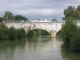
| bridge | aqueduct |
| description | Il s'agit du second pont-canal du canal latéral à celui du Midi. L'ouvrage en pierre de taille du Quercy comporte trois arches couvertes en plein cintre. |
| heritage | 3 |
| heritage:operator | mhs |
| heritage:website | http://www.culture.gouv.fr/public/mistral/mersri_fr?ACTION=CHERCHER&FIELD_1=REF&VALUE_1=PA47000060 |
| historic | bridge |
| image | https://upload.wikimedia.org/wikipedia/commons/thumb/d/da/Baise_kanalbruecke.jpg/280px-Baise_kanalbruecke.jpg |
| layer | 1 |
| mhs:criteria | bassin, écluse |
| mhs:inscription_date | 2003-08-21 |
| name | Pont-Canal de la Baïse |
| ref:mhs | PA47000060 |
| source:heritage | Ministère de la Culture - 07/2018 |
| start_date | 1850 |
| waterway | canal |
| wikidata | Q2412694 |
| wikipedia | fr:Pont-canal sur la Baïse |
Part of
1 relation
- Relation Canal Latéral à la Garonne (301845) (as main_stream)
Nodes
2 nodes
- 851606639 (part of way Canal Latéral à la Garonne (104034522))
- 232173216 (part of way Canal Latéral à la Garonne (104118568))
Welcome to OpenStreetMap!
OpenStreetMap is a map of the world, created by people like you and free to use under an open license.
Hosting is supported by Fastly, OSMF corporate members, and other partners.
| https://openstreetmap.org/copyright | https://openstreetmap.org |
| Copyright OpenStreetMap and contributors, under an open license | |