Changeset: 61484899
Created relation.
Closed by Howpper
Tags
| changesets_count | 8450 |
|---|---|
| created_by | iD 2.10.0 |
| host | https://www.openstreetmap.org/edit |
| imagery_used | Mapbox Satellite |
| locale | en-US |
Discussion
-
Comment from Carnildo
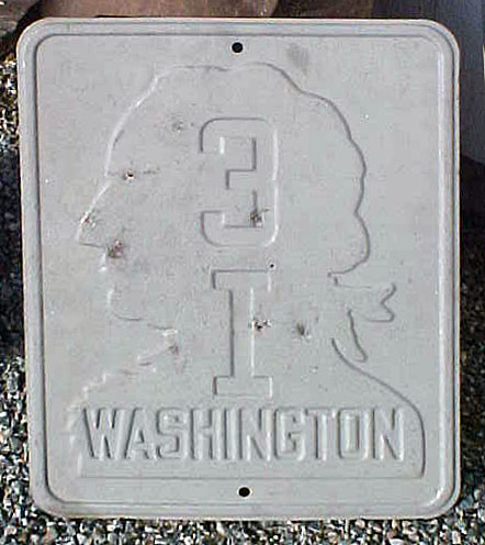
Where are you getting the name "3I" from? Looking at historic topo maps, it appears to be "state highway 31", and I can't find a reference to it that's less than 68 years old.
-
Comment from Howpper
I am 100% certain it was 3I. It took it's name from Primary State Highway 3. There were 22 primary state highways, so it couldn't have been 31. Secondary state highways always had letters and took their number from their parent route. Here is a shield of it: https://www.aaroads.com/shields/img/WA/WA19380031i1.jpg
-
Comment from Howpper
The most likely reason for the lack of info on it is the fact that it was decommissioned before the state highway renumbering in 1964.
Ways (5)
- East High Drive (615410922), v1
- South McClellan Street (615410923), v1
- East High Drive (6152596), v13
- South McClellan Street (205997079), v12
- Park Inn Bar & Grill (488964544), v2
Relations (2)
Nodes (1)
Welcome to OpenStreetMap!
OpenStreetMap is a map of the world, created by people like you and free to use under an open license.
Hosting is supported by Fastly, OSMF corporate members, and other partners.
| https://openstreetmap.org/copyright | https://openstreetmap.org |
| Copyright OpenStreetMap and contributors, under an open license | |