OpenStreetMap

Stereo's Diary

Recent diary entries

Dear OpenStreetMap Community and fellow mappers,

As we say goodbye to 2023, I reflect on a year of growth and development in the OpenStreetMap project.

This year has seen substantial increases across various metrics:

  • Nodes: Increase of 731,936,003 since last year (9.09% annual increase, over 2 million daily)
  • Ways: Increase of 83,077,150 (9.21% annual increase, over 200 thousand daily)
  • Relations: Increase of 1,183,690 (11.37% annual increase, over 3,000 daily)
  • Registered users: Increase of 1,161,850 (12.25% annual increase, over 3,000 daily)

These statistics, accessible here and here, not only quantify our growth but also demonstrate the dynamic evolution of our project.

Beyond these numbers, the real essence of OpenStreetMap lies in its community. The launch of our new community discourse has fostered more vibrant and quality discussions than ever before, thanks to the dedicated efforts of our moderation teams in maintaining a constructive and respectful environment. The migration of all old forum content was a major effort by the Operations Working Group.

The board, in collaboration with the communications working group, has enhanced transparency and engagement through more frequent blogging, and community consultations on major projects. We also updated our mission statement to better reflect the OSMF’s actual work.

Since late 2020, successive boards have been shaping the OSMF’s first strategic plan, informed by extensive feedback from OSMF members and the broader community. This plan, finalised in September, provides a clear direction on future endeavours in key areas like technical infrastructure, community development, institutional development, and financial governance.

Our budgeting and accounting processes have also seen significant improvement through new tools and the efforts of volunteers, ensuring more effective support of our operations and growth. The next boards can more easily build budgets and show how the Foundation spends its funds.

Celebrating our 19th birthday this August, we embarked on a broad fundraising campaign to support the project’s future. Thanks to the generosity of 2450 donors, we have raised € 96,098.23. The income and high number of donors are crucial in ensuring our independence and catering to everyone’s interests.

We’ve revised our corperate membership guidelines, enhancing the mutual relationship between OSM and organizations that rely on our data. Key points include wider access to the advisory committee, a 50% membership fee increase, and additional Platinum tier benefits. Notably, TomTom and Microsoft joined as our first Platinum members.

We formalised our relationship with HOT, with an agreement on HOT’s use of the OpenStreetMap trademark, and HOT joining our corporate members at the Silver tier.

We continue to navigate the complexities brought on by Brexit: taxation and employing staff are needlessly expensive and complicated, EU database rights are harder to apply, and banking is a hassle. We now have a plan to migrate the OSMF to the EU, a significant move that the next Board will bring to the community for consultation.

The Overture foundation’s emergence has been noted with interest, recognising potential synergies and challenges it presents.

The Engineering Working Group has been pivotal in advancing our technical frontiers, including a new contract to implement minutely updated vector tiles on openstreetmap.org, unlocking many new cartographic possibilities.

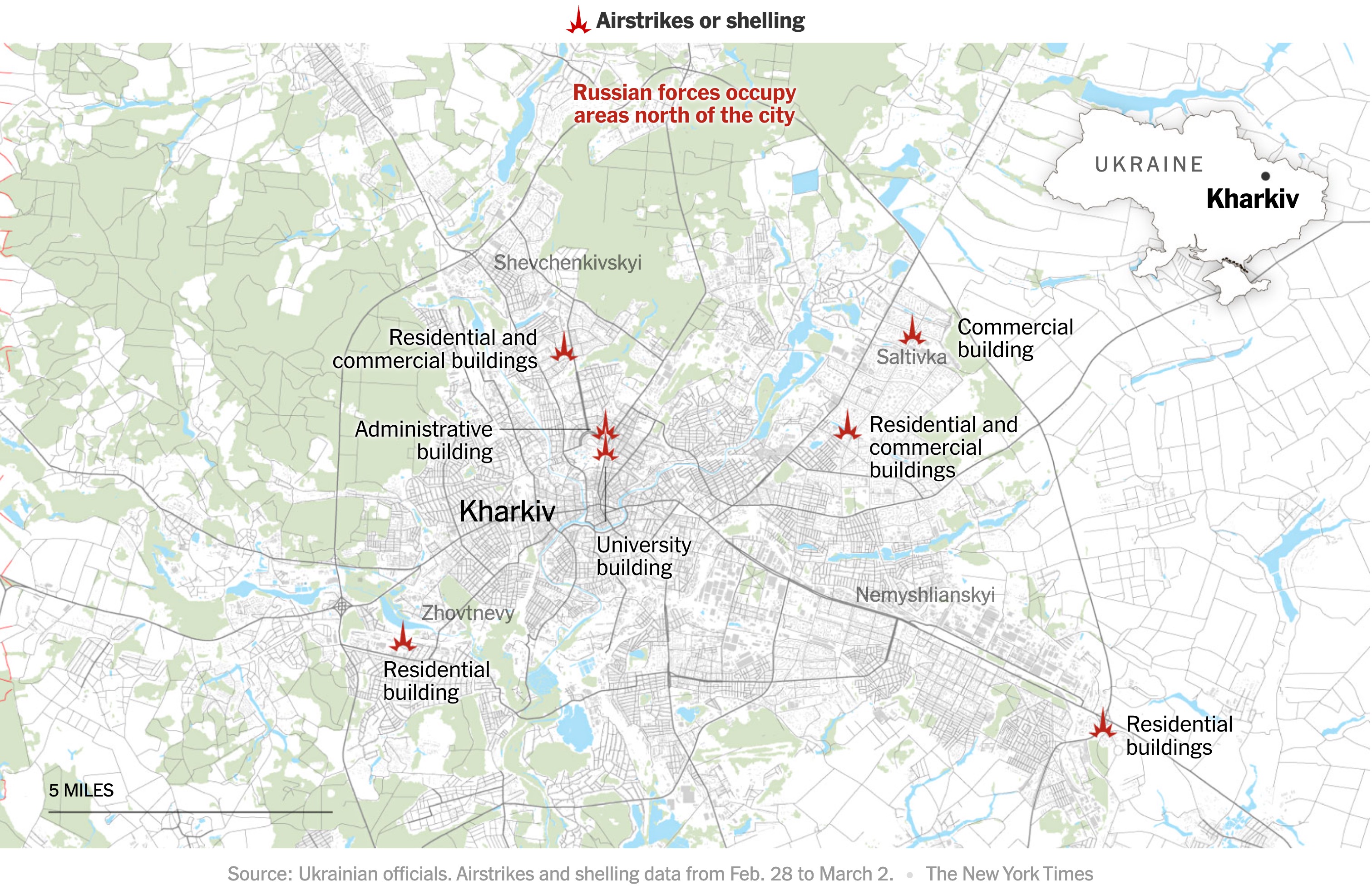
We encountered significant vandalism in Ukraine and Israel. The vandals used automated approaches and other tricks. The work of the Data Working Group and other volunteers, website changes, rate limits, and improvements to the DWG’s tools have solved the issue. Our response to sophisticated vandalism exemplifies our resilience and adaptability, underlining our commitment to data integrity.

Maxar stopped letting us use their imagery without warning or communication, leaving many mappers without a good alternative. However, the challenge has encouraged us The OSMF participates in an informal imagery group, led by OpenStreetMap US, to work on identifying areas where imagery is needed, serving it from OSMF infrastructure, and adding it to various editors.

The global State of the Map (SotM) conference will take place in Africa for the first time in September 2024. See you in Nairobi!

While we didn’t welcome new local chapters this year, ongoing applications suggest promising expansions in 2024. We aim to enhance local chapters’ role in OSMF’s decision-making, recognising their critical contributions to our growth and diversity. A new communities page on the main website helps showcase local chapters.

Membership in the OSM Foundation has steadily increased, now standing at 2,161. This growth - albeit modest: we passed 2000 members in 2021 - underlines our community’s commitment and paves the way for more ambitious recruitment initiatives in the future. High membership numbers help safeguard our independence.

Like I wrote to you in 2022, the Board’s workload keeps being too heavy for its overstretched directors, and the Board is too often the project’s bottleneck. The Board is working on writing down its thoughts on hiring an executive director.

As we move forward, the dedication and efforts of the entire OSM community - mappers, volunteers, developers, donors, staff, and you, Foundation members - remain our greatest strength. I extend my heartfelt gratitude to everyone.

I want to thank Mikel Maron, who is retiring from the board. Mikel has spent a total of 13 years on the board, and his experience and expertise will be missed.

Thank you all for your contributions, unwavering dedication, and passion for mapping. Here’s to another year of fruitful collaboration and success.

Happy mapping,

Guillaume Rischard Chairperson, OpenStreetMap Foundation

Location: Manhattan Community Board 1, Manhattan, New York County, New York, United States

Dear OpenStreetMap Community, fellow mappers

It is my pleasure to present the annual report of the OpenStreetMap Foundation for the year 2022.

First and foremost, we have been thrilled to welcome Grant, our first employee. He has joined the OpenStreetMap Foundation as our senior SRE after many years of volunteering on the Operations Working Group, and we believe that his expertise and experience is a valuable asset to the OpenStreetMap Foundation. We now finally have someone with the both the time and experience to tackle the big infrastructure projects that will lead us to increased resiliency and stability.

If you would like to learn more about Grant and his work, you can listen to an interview with him on the geomob podcast.

The growth of the OpenStreetMap project isn’t slowing down. We recently passed 8 billion nodes, 900 million ways and 10 million relations. We will reach 10 million registered users in 2023.

As the OpenStreetMap project continues to grow, the workload for the Foundation’s volunteer board members has also increased. While we are thrilled to see the project’s success, it is important to acknowledge that this growth also comes with its challenges. In particular, the increased workload can be overwhelming at times, and it is not always easy or fun. This year has, counterintuively, been marked by a relative lack of activity from the Foundation’s board members. While this is not new or unique to the OpenStreetMap Foundation, several of our board members have experienced burnout and have taken a step back from their roles. The burden of board work can be heavy - you join because you think maps are fun, and you end up spending your free time knee-deep in finance, HR and legal matters.

Our finances, as the treasurer will outline, are in good health. To help accompany the challenges the project mentioned in our strategic plan outline, our work in 2023 will include an emphasis on increasing our fundraising efforts. By generating additional revenue, we hope to be able to provide more resources to match our success and growth, and support the Foundation goals of increasing the project’s stability and reliability, as well as resources for the broader OpenStreetMap community, including through our local chapters. Mikel, Roland and I, the three continuing board members, have attended a very interesting fundraising seminar by Aspiration Tech, who also facilitate the board’s yearly face-to-face weekends.

In the long term, I believe that the OpenStreetMap Foundation should have an executive director. They would be responsible for overseeing the day-to-day operations of the Foundation, and would provide valuable support and guidance to the board members. This would allow the board to focus more on strategic planning and decision-making, rather than on operational tasks. It would also, like what happened when hiring Grant, let the OpenStreetMap Foundation tackle big projects such as fundraising, attribution, and dealing with the fallout from Brexit which keeps imposing high costs and complications on the OSMF. Our friends at OpenStreetMap US have shown that having an executive director can be a way of empowering the community.

We are pleased to report that the 2022 State of the Map conference was a great success. The conference, held in Florence, Italy, featured a wide range of interesting presentations and discussions, and brought together members of the OpenStreetMap community from around the world.

Unfortunately, we have had to make the difficult decision to cancel next year’s State of the Map conference. We understand that this decision will be disappointing to many members of the community, but the State of the Map working group believes it is the best thing to do to have an even better conference in 2024.

After a long period of community consultation, we have passed new Etiquette guidelines to provide a safe and positive community experience for all. While originally intended for the mailing lists, the guidelines have since been used by many communities on our new community forum. We have nominated a team of mailing list moderators, and they have also since agreed to moderate the community website.

We have revived the Engineering Working Group, and, for the first time, given it a budget. EWG started by asking Jochen Topf to write an interesting report on the future of the OpenStreetMap data model, and is now calling for bids to work on our website to add a mute feature.

Our work on takeover protection continues. We have recently decided, after a community survey, to only allow new members to join the OSMF if they have mapped a minimum number of days in their lifetime, ensuring skin in the game. It is hard to gauge the success of such things, and to take actions where the positive outweigh the negative. I expect that future boards will continue to discuss the question.

We have welcomed OSM Austria as a local chapter, and now have 18 local chapters, representing the diversity of mappers from every continent except Antarctica.

The board is growing in diversity, too: the candidates for the board election this year are from Asia, North America, Europe, South America and Africa, which I think is a record.

I would like to take this opportunity to thank everyone who contributes to OpenStreetMap: the mappers most of all, but also the working group volunteers, the programmers, the sysadmins, the cartographers, Martin and Harry who have done programming contracting work, and Dorothea and Michelle who support the board’s work.

Finally, I want to thank the outgoing board members for their service to the OpenStreetMap Foundation. Your hard work and dedication have been invaluable, and we are grateful for your contributions. We wish you all the best in your future endeavors.

Happy mapping,

Guillaume Rischard

Chairperson, OpenStreetMap Foundation

Location: Bellingham, Southend, London Borough of Lewisham, London, Greater London, England, SE6 3HD, United Kingdom

The New York Times has maps tracking the Russian invasion of Ukraine. I wondered what the data source of the first one was: were they maybe using OSM?

New York Times map of attacks on Kharkiv

Mappers on the #openstreetmap IRC channel quickly found some differences. Just to be absolutely sure, I used the QuickOSM plugin for QGIS to download OSM data for the area from overpass. I then quickly styled the map, using the colour picker to copy the Times map. In half an hour, I had my own map of Kharkiv.

OSM-based version of the same map

The maps are quite different. The OSM-based one has more roads, especially in the forest. The land use is more accurate and up to date. The Ukraine community has done a great job.

The New York Times isn’t using OpenStreetMap, but an inferior, probably commercial source. Otherwise, their map would be better ;).

Location: Новобаварський район, Kharkiv, Kharkiv Urban Hromada, Kharkiv Raion, Kharkiv Oblast, Ukraine

Mapping leads to the end of winter

Posted by Stereo on 10 February 2022 in English.

The trumpeting calls of the common cranes on their migratory flights high above Luxembourg announce autumn in September and spring in February. We look up, and for a few seconds, their V-shaped patterns peacefully mark the natural passage of time.

I live an ocean away in New York now. The colder winters last longer. When I hear about construction at home, or maybe feel a bit homesick, I turn to mapping.

Local citizen initiatives have been using OpenStreetMap’s pedestrian crossings to crowdsource data on crossings with parking spots built too close. I have been improving crossings to help out, manually going through points marked as can’t see in ZUG’s analysis. For this crossing, too recent for aerial imagery, a friend sent photos from the ground. I compared the aerial images from previous years to compare how construction had changed the area, and spotted cranes announcing the end of winter in February 2019.

Common cranes over Luxembourg

Location: Limpertsberg, Luxembourg, Canton Luxembourg, Luxembourg

OSMF survey on board priorities - a quick analysis using the Borda count.

Posted by Stereo on 21 February 2021 in English. Last updated on 22 February 2021.

The raw results of the 2021 OSMF Community Survey have now been posted. One of the questions asked people to rank seven choices for what the board should work on:

In 2021, what do you think should be the priority order of tasks the Board of Directors has set for itself?  Please rank the tasks in order of relative importance to the OSM project.

A vote counting method that’s relatively easy to implement in a spreadsheet on a Sunday evening is the [Borda count]. I’ve done a slightly modified one - an option at first rank gets 7 points, second rank 6 points, etc., until 7th rank gets one point.

The results actually match the results if you rank by first preference. Fund-raising gets high ranks in subsequent preferences, but because it’s not high in the first preference, it ends up in the middle of the final count.

Choice Borda score
Stability of the core infrastructure (hardware, software, human capital) 16591
Takeover protection 11179
Outreach to Local Chapters and Communities 9799
Fund-raising 9529
Attribution guidelines 8307
Recruitment for Working Groups 8299
Brexit 4330

Does anyone want to try a Condorcet ranking?

I mostly agree with that list of priorities.

I hope that I find enough free time to work on hiring our Senior Site Reliability Engineer very soon.

Board members don’t agree on how much a threat takeover is, and how to protect against it - this is definitely something where the members need to make their voices heard. Message me, email the board, post in the comments below.

Brexit is important because it threatens the way we can enforce our database rights in the EU. Locating at least part of the OSMF to the EU would have some advantages, and this might be the final straw that convinces us that we need to open a legal entity there. The current plan is for Rory and I to talk to an EU corporate lawyer - again, once we find enough free time.

Location: Hollerich, Luxembourg, Canton Luxembourg, Luxembourg

Christoph Hormann has recently blogged his 2019 OSMF board candidates analysis and recommendations . I’ve submitted a comment which seems to have become stuck in a spam filter, so here it is again:

Hi Christoph,

Thank you very much for your endorsement! I would like to clarify my position on attribution.

Without any doubt, we should not “[ask] nicely but not do anything of substance.” Attribution, as I write in my answer, is essential. We must make sure that our guidelines are crystal clear about what we expect. Clear and reliable guidelines are good not only for contributors. Reusers need guidelines they can trust to frame how they can use OpenStreetMap, without the risk of upsetting mappers.

Any license, without the potential of enforcement, is nothing but words, and of no strength to secure an open project at all. When the guidelines aren’t met, we do need to be able to go further than ask nicely. The recent action by the board to give FOSSGIS a PoA in one case to enforce attribution is a very positive thing.

Location: Hollerich, Luxembourg, Canton Luxembourg, Luxembourg

OSMF signups by hour, November 2018 (UTC)

100 persons employed by one company joined the OSMF in an orchestrated, directed campaign on 15 Nov, which has been discussed on the [osmf-talk] mailing list and elsewhere.

The Membership Working Group’s investigation has uncovered evidence that the company behind the campaign, GlobalLogic, is not being truthful, and that the members did not sign up individually. GlobalLogic has provided versions of the event that are contradictory and not credible.

We do not know the motivations for this campaign, but strongly suspect that this was an attempt, luckily unsuccessful, to influence the recent OSMF board election.

Our intensive research took two main investigators more than a month, with the precious help of many in the community. On 2018-12-26 we presented our detailed report to the OSMF board. We are now releasing it to the membership.

Some key points of the investigation are the fortuitous French control group (p. 7 and onwards) and the lowercase anomaly (p. 14).

We expect this will raise a number of questions in the community: some concerning the incident itself, others related to wider governance. The report makes several recommendations.

MWG and the authors will try to answer any questions you have about the report here, but can also be contacted at membership at osmfoundation.org.

The full report is here (PDF)

Steve (.US) & Guillaume (.LU), for the Membership Working Group

Location: Hollerich, Luxembourg, Canton Luxembourg, Luxembourg

As we approach the 2018 OSMF general assembly, I am extremely thankful for the support and endorsements that I have received from mappers.

Peter Barth, who is retiring from the board, has said some very nice things about me on the German Radio OSM podcast, chapter 32.

Christian Quest, cofounder and speaker of OpenStreetMap France, has endorsed me in a blog post:

The absence of conflict of interest and a good knowledge of the community in its diversity seem to me to be the main criteria.

Richard Fairhurst, former OSMF board member and father of the Potlatch editor and cycle.travel, has tweeted some of the nicest things about me:

I hope [Guillaume Rischard] is elected: smart, grounded, widely experienced and with a real sense of OSM’s potential, he’d be a great asset to the board and to the project in general.

I’m delighted to see the likes and retweets that this received from other mappers too.

You don’t expect candidates to endorse another, but that’s what Jo Walsh tweeted:

I’m impressed with the amount you’re doing for OSM behind the scenes and hope you get elected, as grassroots members would trust the Board more if you were on it.

Then there are all the wonderful private messages of support and encouragement. Thank all of you.

Thank you to all the OSMF members – the fact that we’re 1041 voters this year shows how many care about the OSMF. Thank you to my fellow candidates, for your time investment, for the positive campaign and for the spirit of comradeship I have felt with you.

510 people have already cast their ballot. If you haven’t yet, you have less than 24 hours to do so. The last election was decided on 19 votes, so your vote matters! Please vote, encourage OSMF members around you to vote. A high turnout will make the community stronger and the OSMF more resilient.

If you haven’t chosen for whom to vote yet, here are my answers to the official questions and manifesto.

Important: When voting on opavote, enable JavaScript and disable ad blockers and plugins like Decentraleyes. You risk casting a blank ballot otherwise!

Location: Hollerich, Luxembourg, Canton Luxembourg, Luxembourg

The OpenStreetMap project is organized on an international level by the OpenStreetMap Foundation, under British law.

Some companies are paying employees to join, and there are rumors that they give voting instructions.

In recent years, the Board has gradually lost its balance. Over-representation of some areas and groups makes it difficult to maintain a balanced and diversity of government action and raises some conflict of interest issues. Therefore, it is important that all kinds of mappers join in to balance things out.

On December 15 there are board elections, and everyone who was a member before November 15 can vote.

489 ballots were cast during the last election. By way of comparison, in the last few days, 17 employees from a single US company have joined. This might not be anything sinister, but it’s worrying especially shortly before the board election, and getting the largest amount of OSMF members is the best safeguard of balance.

https://join.osmfoundation.org/normal-membership is the form. It costs £15 (about €17 or $20), it takes 4 minutes, it’s important and it’s too late in 24 hours. I am a candidate for the board election, but of course you distribute your votes however you want.

Location: Hollerich, Luxembourg, Canton Luxembourg, Luxembourg

Pristina, the capital of Kosovo, adopts OpenStreetMap as its official tourist map

Posted by Stereo on 2 November 2018 in English. Last updated on 31 March 2019.

Tourist map of Pristina

It is the youngest capital in Europe, a city where years of peace have brought constant street name changes and endless new streets being built. Locals often use landmarks – sometimes long gone – or old or colloquial names when giving directions, which I had to ask for repeatedly on my first trip to Kosovo in May to visit Anne. It’s a cliché to talk of Kosovo’s potential, but it felt especially true when I looked at the map of Pristina, trying to find my way from Bill Klinton Boulevard, which has a huge statue of him, to Rruga B, which has changed to a name no one remembers or uses.

Big proprietary map makers can’t and don’t care to keep up. Even more than elsewhere, the best map of Kosovo can only come from local mappers.

On my next visit, together with the wonderful OpenStreetMap community, I organised a meetup. This led to very productive meetings with Kosovo’s national cadastre agency. I’ll hopefully have more to write about open geographical data in Kosovo soon.

Other meetings happened with the city of Pristina, and Yll Rugova, who is among others the director for tourism for Pristina, showed up at our second meetup a week ago. We talked about the challenges that come with putting Kosovo on the map, and his ongoing project to create a tourist map of the city. He looked delighted when I showed him Maposmatic, and how easy it was to generate what he needed in different sizes and styles and modify the PDF output.

Only a few days later, this is the result (or in Albanian) – the official tourist map of Pristina is based on OpenStreetMap. The translations and printed versions are coming soon, and I’m sure other, even better maps will follow. Congratulations to Yll, to the Kosovo mapping community and to the city of Pristina.

(Edited to add link to English map)

Location: Lakrishtë, Pristina, Municipality of Pristina, District of Prishtina, Kosovo

Our new organised editing guidelines, as the DWG is now calling them, are on the agenda of the next OSMF board meeting.

I will attend it to present our guidelines and answer questions. In the meanwhile, here is my report. I’m also happy to answer any comments below.

We at the DWG are, first of all, thankful for all the constructive input we have received, from the advisory board, the humanitarian mapping initiatives and the mapping community.

This version of the organised editing guidelines took a lot of work to prepare. We have received and integrated a lot of feedback to reflect consensus and existing good practice.

We have looked at what similar policies would exist, on OSM or in other organisations. I believe that no other project, open or proprietary, has faced this exact issue before. On OSM, contributors generally understand the current policies on automated edits and imports. We have written the organised editing guidelines in a similar way, while adopting a slightly softer approach – not following the organised editing guidelines isn’t an offence per se. Elsewhere, Wikipedia has numerous policies some vaguely similar, but the problems they face are quite different, and their policies tend to be a lot more complex.

Internally, we have looked back at past problematic edits. We have carefully written the guidelines and defined the scope to prevent those problems without creating loopholes or negative incentives like encouraging salami tactics. They are not meant to apply to community activities like mapping parties between friends or making a presentation on OSM at a local club, but only to ‘sizeable, substantial’ activities. We want something that doesn’t scare casual events off while letting us regulate a geography class gone berserk or a misguided volunteer mapathon.

We also don’t want to set hard limits in stone since they would have to go back to the Board constantly if we need to refine exactly what falls under the guidelines.

Humanitarian activities deserve our fullest support. We have therefore adapted the guidelines for them, both implicitly, by requiring only a best-effort approach, and explicitly, by exempting emergencies from the two-week discussion period. Some humanitarian edits have been problematic before, and the guidelines are easy to follow; a blanket exemption would send the wrong signal.

We see the amount of corporate good will at SotM, the tensions in the community, and the (dis)organised edits that mappers refer to us. Publishing the guidelines will be good for everyone. Good actors, existing and new, will be able to trust clear expectations. The community will be confident that this is the consensus that will be respected. Confused newcomers will get a blueprint for a successful organised edit.

We have written guidelines that will be easy to read and follow and provide clarity on how good organised edits should run without having a chilling effect on them. DWG proposes that those guidelines should now be officially published. OpenStreetMap needs them now more than ever.

Location: Hollerich, Luxembourg, Canton Luxembourg, Luxembourg

Old-style multipolygon cleanup in Luxembourg

Posted by Stereo on 8 December 2016 in English. Last updated on 10 December 2016.

Inspired by Jochen Topf’s old style multipolygon writing, I have just finished manually cleaning up (most? all of?) the remaining old style MPs in Luxembourg.

The process is currently quite tedious. If we want to put old-style multipolygons behind us, we need to make it easier to find them, convert them, maybe even get editors to automatically convert them on the fly when they’re touched. QA tools like Osmose could also possibly make it a one-click JOSM remote fix.

The method I used was downloading a Luxembourg extract, then searching for type:relation type=multipolygon tags:1 in JOSM. I also had -((type:relation tags:1) | (child (type:relation tags:1))) set up as a filter, but didn’t end up using it, because the MPs would disappear as soon as I’d tag them.

For each MP I found, I would zoom to it (3), click on the outer way, alt-click on that way to select the relation, copy tags from previous selection (utilsplugin2, shift-R) from the way to the polygon, click the way again, and delete the redundant tags on the way.

Sometimes, for joined geometries, I had to select the relation by right-clicking on the parent relation in the tags list.

Since most of these old-style relations haven’t been touched for a long time, I also did some drive-by cleanups. In Luxembourg, the old-style MPs were mostly forests.

Did I get all old-style MPs, or only most of them? If there are multipolygons out there on which both the outer way and the relation are tagged, my find pattern didn’t find them. These are possibly the most ambiguous ones, e.g. conflicting tags on outer way and relation, and should be fixed. Has anyone got a good easy way to find them? I tried hasRole:outer -untagged but that found a lot of false positives.

Location: Ville-Haute, Luxembourg, Canton Luxembourg, Luxembourg