Loading...
Node: Archway Station (469759918)
Version #10
Add whether public transport stops are lit
- Edited by Quietmistymorning
- Changeset #126172228
- Location: 51.5647777, -0.1348059
Tags
| bench | yes |
|---|---|
| bin | yes |
| check_date:shelter | 2022-09-14 |
| highway | bus_stop |
| lit | yes |
| local_ref | W |
| name | Archway Station |
| naptan:AtcoCode | 490000008W |
| naptan:Bearing | S |
| naptan:CommonName | Archway |
| naptan:Indicator | Stop W |
| naptan:Street | JUNCTION ROAD |
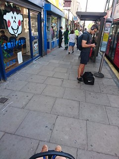
| photo | https://farm5.staticflickr.com/4450/37510442896_9f24360bca_n.jpg |
| public_transport | platform |
| ref | 47949 |
| shelter | yes |
| tactile_paving | no |
Part of
3 relations
- Relation Archway Station (200338) (as platform)
- Relation London Buses route 134 → Warren Street (545598) (as platform)
- Relation London Buses route 390 → Victoria (4005622) (as platform_entry_only)
Welcome to OpenStreetMap!
OpenStreetMap is a map of the world, created by people like you and free to use under an open license.
Hosting is supported by Fastly, OSMF corporate members, and other partners.
| https://openstreetmap.org/copyright | https://openstreetmap.org |
| Copyright OpenStreetMap and contributors, under an open license | |