Loading...
Way: Hofkirche (267389855)
Version #5
Evangelische Kirchen Erkelenz
Tags
| addr:city | Wassenberg |
|---|---|
| addr:country | DE |
| addr:postcode | 41849 |
| addr:street | Roermonder Straße |
| amenity | place_of_worship |
| building | church |
| deanery | Kirchenkreis Jülich |
| denomination | protestant |
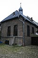
| description | Hofkirche, evangelisch, Barockorgel mit Glockenspiel, Gotteshaus von 1652 bis 1964, rest. 1977. |
| diocese | Evangelische Kirche im Rheinland |
| heritage | yes |
| historic | building |
| image | http://upload.wikimedia.org/wikipedia/commons/thumb/7/7c/Wassenberg_Denkmal-Nr._03%2C_Roermonder_Stra%C3%9Fe_%285108%29.jpg/80px-Wassenberg_Denkmal-Nr._03%2C_Roermonder_Stra%C3%9Fe_%285108%29.jpg |
| name | Hofkirche |
| note | 51.1001176; 06.1558831 |
| parish | Evangelische Kirchengemeinde Wassenberg |
| religion | christian |
| service_times | Su 9:30 |
| start_date | 1652 |
| website | http://www.ev-kirche-wassenberg.de/ |
| wikipedia | de:Liste der Baudenkmäler in Wassenberg |
Nodes
12 nodes
- 2728498815 (part of way 267389888)
- 2728498773 (part of way 267389888)
- 2728498758 (part of way 267389888)
- 2728498748 (part of ways 267389919 and 279422691)
- 2728498737 (part of ways 279422691 and 279422685)
- 2836304385 (part of way 279422685)
- 2728498759
- 2728498763
- 2728498766
- 2728498768
- 2728498827
- 2728498815 (part of way 267389888)
Welcome to OpenStreetMap!
OpenStreetMap is a map of the world, created by people like you and free to use under an open license.
Hosting is supported by Fastly, OSMF corporate members, and other partners.
| https://openstreetmap.org/copyright | https://openstreetmap.org |
| Copyright OpenStreetMap and contributors, under an open license | |