
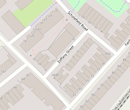
I just added Zoffany Street to the map in more detail (all buildings and addresses):
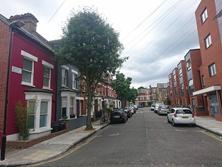
It’s a very short little street. A modern block of apartments on one side, and old cutesy coloured houses on the other. Relatively unremarkable except…
UK geonerds may recognise the name, because Zoffany Street was the last street in the “A to Z”. You can read ‘From Aaron Hill to Zoffany St’ bbc article, and many other tellings of this story, but very briefly… The A-to-Z road map of London was first created as a one-woman effort by Phyllis Pearsall. Annoyed about lack of detail/usability in other maps, she decided to do a crazy thing. She went and walked all the streets of London and created her own new map from scratch. Sound familiar? Phyllis Pearsall died 8 years before OpenStreetMap was born, but she surely would’ve enjoyed those first London mapping parties.
In that original A-to-Z atlas, Zoffany Street was the very last street appearing in the index. London got bigger, with more Z’s in there since, but originally Zoffany Street was the final “Z” in the “A-to-Z”! So good job I’ve mapped it properly now.
Discussion
Comment from EdLoach on 30 October 2017 at 15:32
Does the fence at the back of the building really run diagonally to the corner of the building, rather than parallel to the footpath? It just looks strange, and I wondered if the building node just accidentally got added to the way.
Comment from Harry Wood on 30 October 2017 at 16:23
heh. I wondered what the first hyper detailed mapping comment would be. The diagonal fence does look a bit like a mapping mistake hey? but no. It’s diagonal. Although it might not be very accurately done. Can’t see it all in bing. It’s all new. And quite a tall fence. I’ll have to fly drone there some time.
Comment from Warin61 on 30 October 2017 at 23:38
Hi, Thanks for the history on the start of the A to Z .. never knew where that came from. I’m pleased to see that they are now in colour. My old copy I have is black and white! When I first bought one (also Black and White) I was disappointed that it was not in colour as Australian street directories had been in colour for years. Possibly a question of costs.