One of my resolutions this year was to get my OSM tasks in order. In the few moments of free time I made a list of all (well, not all, just the most realistic) ideas for projects in various stages of design and implementation. I will update the progress on a regular basis.

Cristoffs's Diary
Recent diary entries
As always at the end of the year comes the time for summaries and plans for the coming year. Since a great deal of my activities is related to OSM I would like to share my plans with you for the the coming year of 2024. Despite not managing to achieve everything I planned (this year, the previous year), there was still a lot going on. So let’s start with a summary of the events of the year 2023:
- I managed to conduct workshops and lectures promoting OSM in several new places, including the Wroclaw University of Technology and Adam Mickiewicz University in Poznan.
- As every year, I promoted OSM’s go at GisDay held at the University of Lodz.
- I conducted several Mapathons, supporting UN Mappers projects.
- I established cooperation with colleagues from Croatia actively supporting them in updating data, and testing the use of building data from city resources and Overture Maps.
- For the first time I took part in SotM, and I intend to participate in such events periodically.
- The OpenAedMap project has received support from CloudFerro, which has allowed us to expand the functionality of the site, and secure the platform for the future.
- The OpenAedMap.org project has gained support in the form of signing more patrons. The Center for E-Health, Warsaw University of Technology and the Medical University of Wroclaw have taken patronage of the project. I hope to expand the list of organizations supporting our initiative even further next year
Unfortunately, the list of plans that didn’t work out is much longer than I would like. This is what happens when there is not enough time or resources, and sometimes things just don’t go as intended.
- I had intended to organize periodic workshops and mapathons, but unfortunately, it failed due to lack of time. I had to, also, turn down several proposals in more distant cities due to lack of budget.
- It was not possible to obtain fundings for the development of the OpenAedMap Project.
- I did not gain enough votes in the OSMF board elections, which means I will keep trying next year.
The list of plans for next year is definitely more ambitious. It includes not only the continuation of projects, but also new items. We will start with the must-have items:
- The OSM Poland general meeting will be held in 2024, where, in addition to recapitulations, elections for the association’s board of directors will be held. I intend to run for the board to continue the development of the association.
- I have submitted OSM Poland as the organizer of SotM Eu 2024 in hopes that we will be granted the right to organize this event.
- As every year, I plan to take part in the organization of GisDay in 2024
- Next year, there will be a good chance to organize Qgis Days and I hope to represent the OSM Poland community at this event.
- Also next year I plan to participate in OSMF Board Elections
- Obtaining funding for the OpenAedMap project to introduce new features.
- As every year, he also plans to actively participate in organizing Mapathons, unfortunately limited to my hometown, or online events.
I hope that among the few people reading this post there will be, someone who support me in achieving these goals. If that’s the case, feel free to reach out to me.
Some time ago we prepared a website that allows you to easily add AED (Automatic Defibrillators) locations to the OSM database. The website is available at: https://openaedmap.org We would like as many people as possible to use it. That’s why we want to remove as many barriers to using this website as possible.
We would like to ask for help in translating into other languages. Translation is done using: Weblate
If you want to add new language beside adding translations here create an issue in GitHub https://github.com/openstreetmap-polska/openaedmap-frontend/issues site uses a list of language to display in navbar.
At the request of OpenStreetMap Ireland, I am sharing the lessons learnt from collecting AED data in Poland. I hope to also help other local OpenStreetMap communities with this type of project.
Instead of an introduction.
There is no official record system for these devices in Poland. Both of these databases are closed and the locations of AEDs they contain are highly imprecise, with descriptions missing in many places and the accuracy leaving much to be desired. Our initial analysis has shown that there is little or no usefulness of this data for rescuers.
For this reason, we have decided to start collecting this data and, in order to facilitate this process, to prepare a portal that will support us in this task and, at the same time, display the devices already entered in order to motivate non-OSMP editors to search for and enter their locations into OpenStreetMap. I will try my best to describe the process we have arrived at by trial and error during this project.
Make a plan!
A necessary step was to adopt a minimum usability label for the location of the devices by talking to colleagues involved professionally or voluntarily in the emergency services, and to turn their comments and experiences into a uniform way of labelling AEDs. The fruits of this work can be found on the Polish wiki page: https://wiki.openstreetmap.org/wiki/Pl:Tag:emergency%3Ddefibrillator.
Thanks to the team who created the dedicated AED portal. And is currently working on its international version openaedmap.org, we have had a much easier process of gathering information and greater reliability. Thanks are especially due Tomek, Ancymon, Filip and many others.
We took the tags access and defibrillator:location as key. The following table describes exactly how we standardised the tags for access:
| value | meaning |
|---|---|
| yes | The device is freely accessible to the public, usually in a capsule located outside the building. |
| customers | The device is available during the opening hours of the building, usually in a locker or capsule located inside the building. |
| private | The device has very limited access and requires the consent and participation of a third party, is most often located in a room or remote part of a building with difficult access, or can be moved. For example, we mark devices located in the vehicles of volunteer fire brigades as such |
In our case, the next step was to prepare a database of local government units, which seemed a logical choice. There are more than 2,500 of these institutions in Poland. With such a number, we decided to conduct a mailing campaign. I developed a form in .doc format and the text of a request for a description of the unit’s location. Thanks to Pooh01, we managed to obtain the telephone number of a VOIP hotline with software, which we wanted to use as a contact point for local authorities. At this Stage, the email and information campaign was led by 2 coordinators. Here, continued thanks to them and the enormous amount of work they put into the project. Thx Pooh01 and Ronczka We divided all these institutions into 3 and set up to send out in groups of no more than 100 - 150 emails in one batch.
After the first group of emails was sent, the data collection form was converted into an .xls table and we made it possible to add this information via a google form. All the time we also informed about the possibility to add data from the portal aed.openstreetmap.pl
Conclusions of this phase
- The helpline did not work out due to technical limitations
- After sending enquiry emails, each parcel was followed by a wave of phone calls for about 2-3 days, you have to be prepared for this, usually several people tried to call me at one time. On the other hand, without many hours of calls, it would not have been possible to obtain so many localizations.
- The form must be legible and prepared in tabular form, preferably in .xls format.
- It was a good idea to add a link to the google form. In this way we collected the data of about 300 devices
- Some of the institutions replied in the form of a traditional letter or a scanned signed .pdf document, which takes much longer to enter.
- A dedicated website with the possibility to enter the data (You already have openaedmap.org at your disposal!) proved to be indispensable
Data, data and more data
All acquired data were entered on the fly into a prepared google sheet where they were initially standardised. It was necessary to verify them and standardise all the data. A colleague Marek verified the data, and without his painstaking work it would not have been possible to enter these localizations so quickly. We also tried to translate the description of the locations into English.
Conclusions of this phase
Responses from individual institutions contained many errors:
- poorly legible descriptions of the locations had to be revised
- the coordinates of the individual units were given in different formats and had to be converted and standardised
- errors in the given coordinates to enable their automatic verification
- inconsistencies in the address data for the given coordinates
- some locations were sent from several institutions and we had problems with duplicate data
The standardisation process took much longer than expected. The final standardisation was done in OpenRefine
Entering data into OpenStreetMap.
Here, thanks are due to Mordechai23, who developed an efficient standard for entering AED locations in Josm and their additional verification at the time of entry. Efficient data entry was made possible by using the ToDo plug-in. The person entering the data performed further data verification.
Conclusions from this stage:
- Data packets contained around 30-50 devices at a time
- Packets were created based on location and similar attributes
- Entry of opening hours, if required, was done in JOSM using a plug-in OpeningHoursEditor
- Additional facilities had to be tagged, e.g. buildings containing equipment, shelters, etc.
- On an ongoing basis, we filled in missing data in the vicinity of the AED equipment
Summary and conclusions
- Substantive support from the Foundation for the Development of Defibrillation in Poland gave us insight into the industry, regulations and recommendations for AEDs and was crucial in gaining medical patronage
- The patronages raised the credibility of the project in the eyes of the institutions
- Cooperation with Yanosik (It is a traffic alert system and free OSM-based navigation.) has allowed us to acquire data more quickly, and thanks to this cooperation, all the data is coming in
- Without a dedicated portal, it would not have been possible to obtain the information
- The group of people involved in the project from the data collection and editing side is a minimum of 4-5 people for Poland
It was fun, but what about now?
Data on AEDs in Poland is gradually increasing. Currently, this is due to a functioning portal and data from Yanosik users. Therefore, we want to focus on the development and promotion of the openaedmap.org website. At the same time, it is an excellent form of promoting OpenStreetMap and the idea of free data.
We would be grateful for any help in this regard and invite all interested parties to contact us. Our plans for the platform are collected in SDD the document is currently in (PL) in the near future I will translate it into English
Warning: you read this at your own risk and you may collide with a wall of text. I’m sorry, but it didn’t fit in a few words.
I listened with interest to Florian’s speech at SotM 2022 (https://youtu.be/BRv-IFp_zZs), unlike him I do not feel I am a long-time contributor, although I consider myself active, both in terms of OSM editing and my activities in the Polish OpenStreetMap community. I would like to add my voice to the discussion and support Florian’s position a bit.
Let me start with why, in my opinion, the replacement of the current OpenStreetMap operating model, both in terms of the organisation and the database, is necessary. The reasons are the threats and challenges that are becoming more and more apparent and, paradoxically, stem from the growing interest in OpenStreetMap and its development.
By way of introduction, I refer you to Jennings Anderson’s speech at SotM from 2020: https://youtu.be/BI0VrPyAtcQ
and the update he made a year later and published in his diary: https://www.openstreetmap.org/user/Jennings%20Anderson/diary/396271
I’ll start with the scaremongering - here’s a list of the threats I think we will face in the near future:
Threat One - loss of community control over the project.
As interest in geodata grows and the cost of generating it increases, more and more companies will become interested in using OpenStreetMap data. Currently, OpenStreetMap data can already be found in Facebook, Appel, Amazon and Microsoft applications. As a reminder, in 2020 their total capitalisation was more than six trillion dollars. According to their OpenStreetMap editing teams, Amazon has a team of 780 contributors, so this is a significant potential that we cannot ignore. I would just like to remind you that in 2018 we already had an attempt to take control of the OSMF (if you haven’t heard about it I suggest you should read https://tcrn.ch/2EDFvpN). As far as I am concerned, the threat is very real and is not necessarily limited to a takeover of the OSMF board, but could involve forcing changes, putting the community in front of a strategy of applying faits accomplis, such as the large-scale use of certain tagging schemes.
Threat Two - the marginalization of the project. I had the pleasure of lecturing and introducing geography students at several universities to the OpenStreetMap project on several occasions and teaching the basics of editing (such as https://osmand.net/blog/osm_editing_croatia/). Each time, most of the listeners were surprised at how many companies were using the data, even though some of the students would be professionally involved in the GIS industry. In a word, OpenStreetMap data can be found everywhere, but we, by not actively promoting the project, are pushing ourselves to the margin. And as some say, OpenStreetMap is becoming the industry’s best-kept secret. Despite the fact that thanks to the passion of many of us, Apple’s maps are getting better and better every year, not many people associate them directly with our project. If we don’t promote and educate, each year there will be fewer and fewer people interested in editing OpenStreetMap, and more and more will become “local guides” for Apple or Facebook.
Threat Three - cognitive error - a wiki among maps. Perversely, this threat is internal and perceived rather from the outside than by ourselves. If we want to explain to someone what OpenStreetMap is, we refer to this comparison. For me, unfortunately, it is wrong. The data collection model is similar, but that’s where the similarities end. The nature of the project is vastly different. The data we produce, unlike wikipedia, generates incredible revenue and savings for the companies that use it. One need only look at least at the development of MapBox, whose capitalisation in 2020 was over one trillion dollars and whose business model has at its core the use of OpenStreetMap data. In my opinion, it’s high time to accept that the effort we put into OpenStreetMap results not only into better maps for Doctors Without Borders, but also into generating real money for others. Ignoring this fact may not seem like a threat at first glance, while over time it will become more and more toxic to the community and could ultimately have a very negative impact on the entire project.
At this point, by the way, I strongly disagree with Florian about his references to wikipedia’s models. We should not draw from Wikipedia experience, because in this case the creation of a vision and action plan did not contribute to growth spurt. In my opinion they lost more than they gained from the implement changes (in Poland many valuable members of the community left and in their place there were no new ones). We need to find our own way. We are a community of communities and we should take advantage of this, as it is currently our greatest asset.
As for the remaining areas Florian mentioned, I agree with his diagnosis, while it needs to be worked on heavily, because for today it is more of a sketch than an action plan. Time is the most important problem. In my opinion, it is much worse than Florian described. It is worth reading the famous in some circles blog post https://blog.emacsen.net/blog/2018/02/16/osm-is-in-trouble/. Although it was written in 2018, it has lost very little of its relevance. What it really means is that we’ve lost a lot of time and not much is happening in many critical areas.
Good example An example of how we should approach the aforementioned threats and the changes in the operation of the community, are the current activities undertaken by the OpenStreetMap Association Poland (OSMP) and the community of contributors gathered around it. We are trying to act on several levels simultaneously, although this is very difficult due to the limited resources.
First Area. Improving OpenStreetMap database. We support the community in developing tools and data gathering to integrate them into OpenStreetMap database. An example is the website https://budynki.openstreetmap.org.pl developed by Tomek Taraś , which allows for the integration of building and addresses data available in Polish public repositories with OpenStreetMap data. Another example is the website https://openaedmap.org/, currently under development, which we hope will contribute to entering of defibrillators data into OSM database. Previously, the Polish version of the website https://aed.openstreetmap.org.pl, allowed us to acquire data of more than 3800 AEDs. Thanks to our established cooperation with the City of Warsaw, we receive bicycle infrastructure data on an ongoing basis and provide it to the community, so that it is entered in OSM on the basis of as-built documentation and verified additionally by local contributors.
Second Area. Education and promotion of the use of OSM data. OSMP has established cooperation with many universities in Poland and organizations related to cartography and eography. As a result, we have conducted many classes and training sessions at these universities. We directly support scientific works, those thematically related to OpenStreetMap and those that use the OSM data. Thanks to an agreement signed with the Association of Polish Cartographers, this year they expanded “the Internet map of the year” competition to include a category of maps based on OpenStreetMap. The member of the OSMP was invited to the jury to support cartographers with his knowledge of OSM.
Third Area. Analysis, updates and monitoring of OpenStreetMap data. With the cooperation of many contributors and constant monitoring of changesets, we are able to prevent vandalism, as well as help new mappers and correct most of the mistakes they make on a regular basis. Despite already existing tools such as https://osmcha.org/, we have noticed deficiencies in these areas. We are currently working to increase our capabilities in this area, but due to available resources, we do not anticipate quick action here.
Fourth Area. Creating and maintaining infrastructure. This is currently our biggest concern. In order to function and build more tools and projects, we need technical infrastructure. We are currently trying to provide the necessary resources so that they can be made available to the community.
Fifth Area. Community integration. The first step was to set up a Discord chanel. Thanks to this the community has become significantly integrated. Another step was social events organized by members of the OSMP in their cities. Although the pandemic has definitely thwarted our plans in this area, we are trying to return to these activities.
In summary, we are trying to support the members of the community in their activities and to be the integrator of these different activities. I would very much like to have the support of OSMF in our efforts.
I would also like to propose the establishment of a working group to create a strategy to be taken for the future. The working group, which should include all OSM communities, should develop a “road map”, starting with the necessary technical solutions, ending with marketing and methods of implementation of the strategy. The issue of securing financial and human resources should be developed as well. I think that our community is so diverse and brings together people with experience from many areas that the strategy developed in this way will allow us to cope with all the obstacles and reform the current structures to ensure the further development of the OSM project in the future.
I’m sure some of you have heard of a map that shows the locations of AEDs in Poland, available at https://aed.openstreetmap.org.pl. Thanks to community activism and a campaign among local government units, more than 3,000 device locations have been introduced. Encouraged by the success of the Polish map, we were then tempted to expand the project’s area of operation to increase community involvement in inputting AED device data into the OpenStreetMap database.
Currently, two members of the OSMP organisation tomczk and starsep are attempting to rewrite the existing version of the website using React technology and implement new functionalities. Their results to date are now available at https://openaedmap.org.
The website will be continuously developing. We would like to prepare websites with statistics broken down by country and make it possible to download data in the same way as in the Polish version of the website. The Colleagues are also working on improving and extending the form to allow not only the addition of device data from the page, but also editing.
Our dream is to expand the functionality with the ability to add photos of devices in order to verify them and make it easier to find them in the field. For which we do not have the technical resources at the moment, but hopefully we can acquire a technology partner to help us with this.
Unfortunately, due to the amount of work this project requires, we need Your help. If you have skills in the following areas please email us at: aed@openstreetmap.pl
We need volunteers to support us with their React.js (front-end) and Python scripting skills, and because of the international character of the project we also need help with translations into languages other than English, with priority for French, Ukrainian, German and Spanish.
The Polish version of this entry is available at: OSMP page
Continuation of my frustration about the OSM Carto style
Posted by Cristoffs on 25 June 2022 in English.31.05.2022 I have published an open letter to the members of the OSMF foundation board regarding the problems I believe the community is facing in creating the main style of OpenStreetMap. The heated discussion that took place around this topic surprised me a lot. I didn’t think that so many involved editors from different parts of the world share my concerns.
On 06.06.2022 at the Engineering Working Group meeting this topic was raised, there is a note about this in the meeting record:
Follow up on osm-carto frustration
Brandon notes that the OWG have an outstanding issue on their public >tracker related to possible technology alternatives to OSM Carto. Unfortunately, >discussion is cut short as the scheduled meeting time is about to end.
As for me it is a bit of a pity.
30.06.2022 13:00 UTC At the meeting of the Board of Directors the mysterious topic of OSM Carto will be discussed. I am already looking forward to my participation in this event. Will you also take part in it? Here is the link for those who are interested:
(https://osmvideo.cloud68.co/user/ror-nt7-6tu)
I hope that this time I will not be disappointed and the board will find a solution to this problem, or at least start a consultation among the community. Which will contribute to the democratisation of the process of creating our flagship style
Niedawno OSMP nawiązało kontakty ze społecznością osób niewidomych w Polsce. Dzięki temu zapoznaliśmy się z ich potrzebami oraz dowiedzieliśmy się jak bardzo dane OpenStreetMap pomagają im w codziennym życiu. Okazało się że większość aplikacji, które wykorzystują do poruszania, opiera się na informacjach pozyskanych z OpenStreetMap.
Obecnie przygotowuję założenia programu skierowanego do edytorów OpenStreetMap, by zwracali przy mapowaniu szczególną uwagę na oznaczanie obiektów, które ułatwią poruszanie osobom niewidomym.
Do grupy takich obiektów należą między innymi: drzwi do budynków, oznaczenia przejść dla pieszych w tym przejścia z drogami rowerowymi, schody oraz bariery komunikacyjne.
Zamierzamy także nawiązać również współpracę w zakresie oznaczania w OSM przystanków komunikacji miejskiej, tak by można było te informacje wykorzystywać do nawigacji głosowej. Taki program pilotażowy indeksacji przystanków w Katowicach już przygotował i dzięki swojemu uporowi i ogromnemu nakładowi pracy wdrożył jeden z polskich edytorów (Chwalmy Luktara!). Zapraszam do poczytania w tym wątku na Forum. Obecnie przygotowuje podobny projekt na terenie Krakowa, OSMP zamierza go w tym wspomóc i jednocześnie zorganizować takie projekty dla innych polskich miast.
Informacje o postępie prac w ramach projektów będą publikowane tutaj, na stronie OSMP oraz na naszych grupach na Facebooku. Zapraszam do śledzenia oraz aktywnego udziału w projekcie.
Recently OSMP has established contacts with the community of blind people in Poland. Thanks to that we got to know their needs and learned how much OpenStreetMap data helps them in everyday life. It turned out that most of the applications they use to move around are based on information obtained from OpenStreetMap.
Currently I am preparing assumptions of the program directed to editors of OpenStreetMap, so that they would pay special attention to marking objects during mapping, which will facilitate movement of blind people.
The group of such objects includes among others: doors to buildings, markings of pedestrian crossings including crossings with bicycle paths, stairs and communication barriers.
We also intend to collaborate on marking public transportation stops at OSM so that this information can be used for voice navigation. Such a pilot program of indexing bus stops in Katowice has already been prepared by one of Polish editors (Let’s praise Luktar!) and, thanks to his persistence and huge amount of work, has been implemented. I invite you to read it in this thread on the Forum. He is currently preparing a similar project in Krakow, OSMP intends to assist him in it and at the same time organize such projects for other Polish cities.
Information about the progress of the projects will be published here, on the OSMP website and on our Facebook groups. I invite you to follow and actively participate in the project.
An open letter to OSMF board members concerning problems with OpenStreetMap-Carto
Posted by Cristoffs on 31 May 2022 in English.Dear board members, it has come to my attention that many community members feel that openstreetmap-carto is stagnating. Some feel that there is no vision, no project goals, and that maintainers don’t care about the community instead trying to follow their own agendas. I am concerned that it may negatively impact long term health of the project.
As the first/default style that is visible on https://openstreetmap.org openstreetmap-carto can be considered one of core OpenStreetMap projects. While it may not be as important as the backend API and database it is the first thing that anyone going to OSM’s site sees. It is therefore of great interest to the entire project that the style is maintained and community is involved and proud of the results.
OpenStreetMap grew as a project and right now it is one of the largest open datasets of geospatial data. Many researchers as well as companies from startups to FAANG rely on OSM. There are more mappers than ever. For a very long time it was all serviced by volunteers but with that growth there is a need for more time and professionalism from maintainers.
As the project grows so does the responsibility. We know that OSM Foundation is trying to help by e.g. hiring new SRE, hiring iD developer, organizing committees and working groups, creating grant programmes. I believe that openstreetmap-carto should at least get involved in Software dispute resolution panel and if possible start leveraging paid resources to help with maintenance and design.
What was reported to us first was that one of our members tried to make a Pull Request adding rendering of some feature to the style and maintainers were hesitant to accept it even after extensive discussions and clear interest from the community. That in itself would not have been a cause for concern - not everything can/should be displayed on the map - but the last comments in the discussion turned to general issues with project maintainership and it was clear that many community members are dissatisfied with how openstreetmap-carto maintainers conduct the discussions and make decisions about the project.
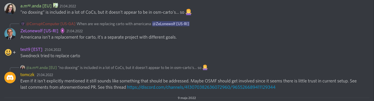
Most concerning however was the comment from swedneck that one of openstreetmap-carto maintainers revealed information about him that he was not comfortable sharing (doxxing) and that nothing was done. Andy - openstreetmap-carto creator - was informed in another comment and ignored it. The issue was raised on OpenStreetMap discord where Amanda - board member - saw it but claimed that carto’s Code of Conduct does not list that doxxing is explicitly forbidden. This is very disappointing as it damages community’s trust in the project. Since then another maintainer Mateusz corrected that some actions were taken but this generated a comment only after I made diary entry that elicited 46 comments making some noise within the community.
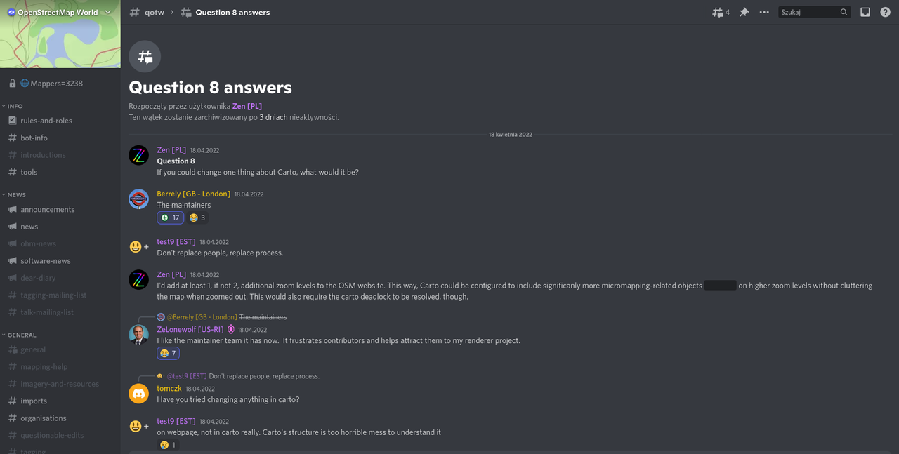
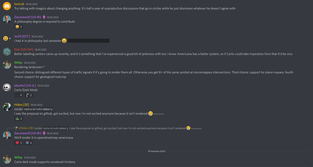
Problems with openstreetmap-carto were raised in discord and again many community members expressed that the project is not very receptive to feedback. In one of threads for Question Of The Week event moderator asked what would the community like to change about openstreetmap-carto and the first response it was proposed that maintainers should be replaced. This response received seventeen “+1” reactions.
It’s clear that there are many people disappointed with the current state of affairs which for such an important project is concerning. I don’t think geospatial data can be disassociated from a map. OSMF choosing to focus only on database/API and editors is not enough in my opinion.
I hope this message will open discussion and meaningful actions can be taken to restore community’s faith that their input is valued in the project.
I have attached discussions that I mentioned (discord plus last part of github PR) so they are all in one place.


Openstreetmap-Carto – Democracy Or anarchy?
Posted by Cristoffs on 17 May 2022 in Polish (Polski). Last updated on 18 May 2022.In the last year our Polish OpenStreetMap community started updating the data of parcel lockers and their locations in Poland. The popularity of these machines has significantly increased during the COVID-19 pandemic. We estimate the increase in the number of these devices in Poland at around 3,000 per year. The mapping campaign and the hard work of many contributors have led to the fact that the OSM data in the case of the introduced parcel machines in Poland is much more accurate than the data that the operators of these machines have. At the moment, we have over 4,200 parcel machines introduced to OSM. So we have potentially another advantage in promoting OpenStreetMap in Poland. Unfortunately, we cannot use it, because the parcel lockers are not rendered on www.openstreetmap.org.
The Polish OSM community made a huge contribution to standardize tagging of these features in accordance with all community guidelines. The process was quite difficult because the comments were diverse (and strong) and it was impossible to take into account all of them. Proposa link These steps were time consuming, but eventually we were able to work out the tagging scheme accepted by the OSM community.
Unfortunately, we are not able to develop a solution that would be satisfying for people responsible for maintaining the CartoCSS stylesheet. All our attempts failed.Git hub discussion
That is why I would like to ask a few questions: Why in some areas of our community project do we have total autocracy instead of democracy? Should the OSMF not change the rules for introducing changes to the style to follow the trends and changes in the world around us? Don’t you have the impression that our Democracy is turning into Anarchy?
Feel free to discuss in the comments. I hope that members of OSMF’s board of directors and members of the working group will also take part in this discussion. Anticipating questions, I published in my diary, because communication through other channels seems ineffective.
Nowości w projekcie mapy AED na dzień 13-02-2022
Posted by Cristoffs on 13 February 2022 in Polish (Polski). Last updated on 23 February 2022.W tym tygodniu ( od 7 do 13.02.2022) udało się nam przekroczyć 2000 zarejestrowanych urządzeń. Powoli przygotowujemy się do zestandaryzowania danych, które zostały wprowadzone. Dla ułatwienia tego zadania, w ramach jednego z repozytorium GitHuba, uruchomiłem wspólnie z edytorem NieWnen (między nami mówiąc, wykonał on najtrudniejszą część pracy) kilka skryptów, które na bieżąco generują raporty oraz tworzą kopię bezpieczeństwa. Raporty są dostępne pod adresem: https://github.com/openstreetmap-polska/aed_backup
Możecie tam sprawdzić między innymi: ile obiektów znajduję się w zasobach OpenStreetMap, ile obiektów zostało wprowadzonych każdego dnia. Wykresy kołowe dla kluczy, jak:
- access
- defibrillator:location
Wartości te mają kluczowe znaczenie dla praktycznego zastosowania lokalizacji tych urządzeń. I właściwe ich oznaczenie zgodnie z przyjętym standardem, może być na wagę życia lub śmierci. Schemat prawidłowego oznaczenia jest umieszczony wiki Warto dodać, że dla klucza access powinniście się ograniczyć dla zalecanych wartości.
customers - Urządzenie jest dostępne w godzinach otwarcia budynku, najczęściej w szafce lub kapsule umieszczonej wewnątrz budynku.
yes - Urządzenie jest publicznie dostępne bez ograniczeń, najczęściej w kapsule umieszczonej na zewnątrz budynku.
private - Urządzenie ma bardzo ograniczony dostęp, wymaga on zgody i udziału osoby trzeciej, najczęściej znajduje się w pokoju lub odległej części budynku z utrudnionym dostępem lub może być przenoszone. Oznaczamy tak np. urządzenia znajdujące się w samochodach Ochotniczych Straży Pożarnej
permissive - Urządzenie ma bardzo ograniczony dostęp, na co dzień dla pracowników np. w domu opieki w przypadku zagrożenia życia.
Jeśli uważasz, że na liście rekomendowanych wartości powinny znajdować się jakieś dodatkowe wartości, proszę napisz na wiki w zakładce dyskusje lub bezpośrednio do mnie.
Podczas wprowadzania danych okazało się, że wiele jednostek Ochotniczej Straży Pożarnej nie było oznaczonych w OpenStreetMap. Dzięki informacji pozyskanej od Samorządowców o AED znajdujących się w ich posiadaniu edytorzy dodatkowo nanieśli ich lokalizację i w wielu przypadkach poprawili topologię w okolicy. Taki mały bonus naszego projektu.
Mapa AED - Podsumowanie na dzień 06.02.2022 - Trochę statystki
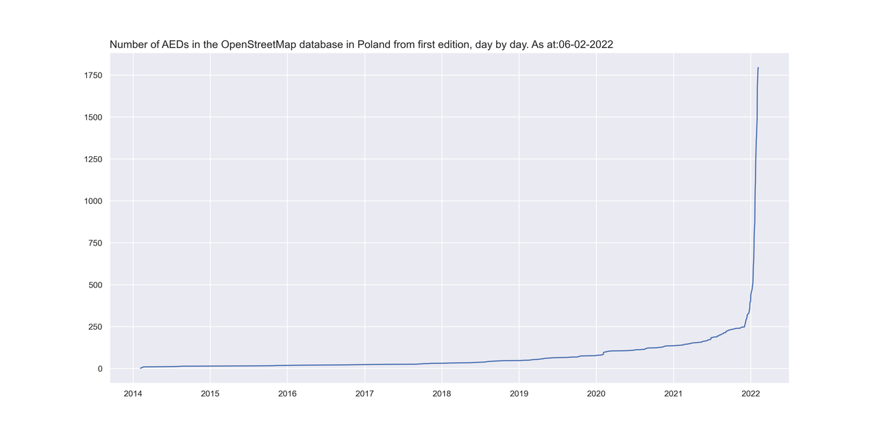
Posted by Cristoffs on 6 February 2022 in Polish (Polski).W kolejnym podsumowaniu działań w projekcie AED będzie trochę statystyki. Najpierw dane od początku świata czyli od połowy 2014 roku. Gołym okiem widać kiedy zaczęliśmy naszą akcję z AED.
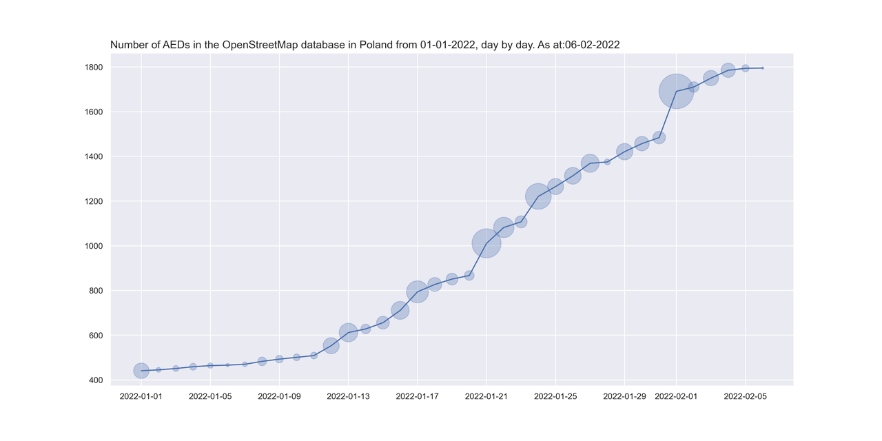
Tutaj mamy dane od początku roku do dzisiaj rana (06.02.2022), Rok rozpoczęliśmy mając w OpenStreetMap 441 urządzeń AED i po ponad miesiącu mamy już 1795 co oznacza, że średnio dziennie dodawaliśmy około 37 urządzeń.
No i na końcu ilość AED wprowadzonych do OSM w podziale na poszczególne województwa. Oczywiście nie są to jeszcze wszystkie i jeszcze wiele pracy przed nami, ale już coś widać. Następnym razem, czyli może za tydzień, czy dwa jak będziemy mieli jeszcze więcej danych zebranych i wprowadzonych zrobię wykres na poszczególne powiaty.
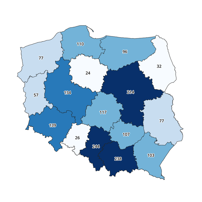
Chciałbym jeszcze raz podziękować wszystkim zaangażowanym w projekt, bo jak widać to idziemy na rekord. Z takimi zespołem góry można przenosić!
W tym tygodniu będziemy musieli zwolnić trochę tępo bo, czeka nas wyłączenie serwera na którym znajduje się strona aed.openstreetmap.org.pl na ponad 24 godziny w celu dokonania prac serwisowych, co spowoduje, że część zespołu będzie miała ręce zajęte za kulisami.
Mapa AED - Podsumowanie na dzień 30.01.202
Posted by Cristoffs on 30 January 2022 in Polish (Polski).W minionym tygodniu udało się pozyskać patronat honorowy dla naszego projektu ze strony czołowych specjalistów medycyny w Polsce. Na liście lekarzy, którzy obdarzyli nas swoim zaufaniem znajdują się:
- prof. dr hab. Jerzy Robert Ładny - Konsultant Krajowy w dziedzinie medycyny ratunkowej
- dr n. med Wiktor Kuliczkowski - Konsultant wojewódzki ds. kardiologii (dolnośląskie)
- prof. dr hab. n. med. Andrzej Wysokiński - Konsultant wojewódzki ds. kardiologii (lubelskie)
- dr hab. n. med. Łukasz Balwicki - Konsultant wojewódzki ds. zdrowia publicznego (pomorskie)
- prof. dr hab. n. med. Marianna Janion - Konsultant wojewódzki ds. kardiologii (świętokrzyskie)
Jednocześnie przebudowaliśmy i rozbudowaliśmy stronę projektu. Wyszukiwanie oraz import danych jest teraz ułatwione. Lokalizacje AED są dostępne do pobrania w formacie csv, xls oraz GeoJson bezpośrednio z poziomu strony. Obecnie mamy zlokalizowanych ponad 1500 urządzeń (stan na 30.01.2022) Cały czas spływają do nas dane z samorządów więc ta ilość będzie się jeszcze zwiększać.
W przyszłym tygodniu będziemy kontynuować akcję mailową, roześlemy zapytania do pozostałych województw, na liście zostały nam jeszcze trzy. Plan na najbliższy tydzień to dalsza optymalizacja strony oraz praca nad włączeniem danych pozyskanych od jednostek samorządu. Mam nadzieję, że do końca lutego uda się zakończyć ten etap.
Pozyskując stopniowo dane będziemy także rozbudowywać stronę wiki poświęconą AED, zgodnie z informacjami pozyskanymi w ramach projektu z uwzględnieniem przykładów tagowania wypracowanymi podczas pracy.
Obecnie w skład zespołu zajmującego się projektem poza mną wchodzą następujący edytorzy:
- tomczyk - dev.team - backend
- Ancymon - dev.team - fronend
- Marek-M - Standaryzacja Danych
- Mordechai23 - Edytowanie oraz importy
- syntex - Edytowanie oraz importy
- Aim311 - Edytowanie oraz importy
- pooh01 - koordynacja, zbieranie danych, kontakty z samorządem
- Ronczka - koordynacja, zbieranie danych, kontakty z samorządem
- FundacjaAED - który nie jest edytorem, natomiast jako prezes Fundacji, która jest partnerem projekti wspiera nas merytorycznie oraz jest odpowiedzialny za kontakty ze środowiskiem medycznym.
Warto także podziękować Mateusz Konieczny za pomoc proceduralną i merytoryczną z zakresy procedur OSMF oraz przy edytowaniu wiki
Należą im się gromkie brawa za poświęcenie wielu godzin pracy, by w tak krótkim okresie udało się dokonać tak dużo.
Ustawienia JOSM przydatne do edycji danych na terenie Polski
Posted by Cristoffs on 26 January 2022 in Polish (Polski). Last updated on 11 February 2022.Klawisz F12 lub wybranie z paska skrótów ikony otwiera okno konfiguracji programu. Warto poświęcić chwilę na dostosowanie zachowania programu tak, by łatwiej było edytować. Na początku polecam włączyć tryb ekspercki JOSM-a, da nam to możliwość dostosowania aplikacji do naszych preferencji oraz włączy kilka niezbędnych funkcji, w tym możliwość zablokowania wysyłania zmian na serwer wybranej warstwy, co będzie pomocne, jeśli chcemy poćwiczyć na „sucho”.
W tym miejscu omawiam wyłacznie najważniejsze i najbardziej przydatne moim zdaniem ustawienia, ten krótki przewodnik nie wyczerpuje możliwości programu, a jedynie ma za zadanie ułatwić edycję dla wszytkich, którzy zaczynają swoją przygodę z JOSM.
Serwer OSM - Autoryzacja konto
Przed dokonaniem pierwszych edycji na mapie koniecznie trzeba autoryzować JOSM, tak by można było zapisać naszą pracę na serwerze OpenStreetMap. Okno OSM Server pozwala nam na konfigurację połączenia z serwerem. Autorzy programu rekomendują korzystanie z protokołu OAuth w celu dokonania uwierzytelnienia. Po jednorazowym podaniu hasła, w celu uzyskania klucza dostępu, proces będzie dokonywany automatycznie przy każdorazowym uruchomieniu programu.
Odwzorowanie kartograficzne
W celu prawidłowej kalibracji podkładu warto sprawdzić, w jakim układzie będziemy pracować. Dla Polski domyślnym odwzorowaniem jest PUWG o kodzie: EPSG:2180, jego stosowanie pozwala na poprawną kalibrację podkładów udostępnianych przez Główny Urząd Geodezji i Kartografii.
Style rysownia
Grupa ustawień pozwalających zmienić sposób , w jaki JOSM wyświetla dane w oknie edycji, w tym wypadku wiele zalezy od preferencji użytkownika oraz obiektów, na jakich się skupia. Dla mnie sprawdzają się następujące:
- Kaart Style - Styl opracowany przez zespół edytorów Kaart-a wizualizujący atrybuty przez zastosowanie wielu kolorów. Dostępny na GitHubie pod adresem: https://github.com/KaartGroup/Kaart-Styles
- fixme and note - Obiekty oznaczone fixme lub note są bardziej widoczne
Szablony
Warto dodać szablony dla obiektów, które często mapujemy, ja korzystam z własnych, są dostępne na GitHubie pod adresem: https://github.com/wzbartczak/Josm_Presets
Wtyczki
W celu pobrania aktualnej listy dostępnych wtyczek należy wcisnąć Pobierz Listę. Po wybraniu listy dostępnych wtyczek możemy pobrać te najbardziej przydatne, ja korzystam z następujących:
- UtilsPlugin2 – rozszerzająca znacznie możliwości edycji, jedna z częście używanych,
- BuildingsTools – ułatwiająca szybkie rysowanie budynków o poprawnej geometri,
- ContinouosDownload - pozwala automatycznie pobierać dane po przesunięciu okna edycji, szczegónie przydatna podczas rysowania dróg lub rzek
- Terracer - dzieli automatycznie budynek na równe części, pomocna przy rysowaniu bliżniaków i zabudowy szeregowej lub ciągu garaży
- ToDo - lista rzeczy do zrobienia tworzona automatycznie o warstwę lub plik
- OpenData - rozszerza funkcjonalność JOSM o czytanie dodakowych formatów danych w tym plików .shp oraz .csv
Sprawdzanie poprawności danych
Ta grupa ustawień pozwala nam okreslić, jakie błędy będą sprawdzane przez JOSMa, kiedy nakażemy mu wykonać sprawdzenie poprawności danych lub będziemy chcieli wysłać zmiany na serwer. Ustawienia w tym miejscu w dużym stopniu będą zależały od waszych umiejętności edytorskich. Im większe, tym więcej warto zaznaczyć.
W JOSMie występują trzy poziomy błędów:
- Błędy - Za każdym razem, kiedy pojawia się błąd z tej kategorii, należy go poprawić, jesli tylko mamy wiedzę, jak to robić, warto zostawić notakę dla innych
- Ostrzezenia - Błędy z kategorii “warto poprawić” nie są krytyczne, ale powinny zostać poprawione. do tej kategorii zaliczane są zduplikowane adresy czy nakładanie obiektów
- Informacje - Ten poziom domyslnie nie jest weryfikowany. Trzeba go zaznaczyć w ustaweniach. W tej kategorii mamy wszytkie braki w ozznaczeniu obiektów, jak naprzykład drogi bez podanej nawierzchni.
W zakładce Reguły Walidacji możemy ustawić dodatkowe, zewnętrzne żródła reguł, Warto tutaj zaznaczyć KeepRight Checks
Zdalne sterowanie
Tutaj zaznaczamy wszytko, dzięki temu, jeśli klikniemy Edycja na stronie OpenStreetMap.org i JOSM, będzie uruchomiony i automatycznie pobierze dane. Tak samo, jesli będziecie korzytali z MapRoulette czy menagera HOT.
Imagery
Mapując w Polsce, najlepiej korzystać z pokładów udostępnianych w ramach usług Geoportalu, sa one także poprawnie skalibrowane. Do najbardziej przydatnych należą:
Obrysy budynków z Krajowej Integracji Ewidencji Gruntów (Usługa WMS)
https://integracja.gugik.gov.pl/cgi-bin/KrajowaIntegracjaEwidencjiGruntow?language=pol&FORMAT=image/png&TRANSPARENT=TRUE&VERSION=1.3.0&SERVICE=WMS&REQUEST=GetMap&LAYERS=budynki&STYLES=&CRS={proj}&WIDTH={width}&HEIGHT={height}&BBOX={bbox}
Punkty adresowe z Krajowej Integracji Numeracji Adresowej (Usługa WMS)
http://integracja.gugik.gov.pl/cgi-bin/KrajowaIntegracjaNumeracjiAdresowej?language=pol&FORMAT=image/png&TRANSPARENT=TRUE&VERSION=1.3.0&SERVICE=WMS&REQUEST=GetMap&LAYERS=prg-adresy&STYLES=&CRS={proj}&WIDTH={width}&HEIGHT={height}&BBOX={bbox}
Ulice z Krajowej Integracji Numeracji Adresowej (Usługa WMS)
http://integracja.gugik.gov.pl/cgi-bin/KrajowaIntegracjaNumeracjiAdresowej?language=pol&FORMAT=image/png&TRANSPARENT=TRUE&VERSION=1.3.0&SERVICE=WMS&REQUEST=GetMap&LAYERS=prg-adresy&STYLES=&CRS={proj}&WIDTH={width}&HEIGHT={height}&BBOX={bbox}
Warto też korzystać z warstwy ISOK, czyli Cieniowanej Rzeżby Terenu, szczególnie, jeśli mapujecie coś w terenie gęsto porośniętym drzewami.
Postanowiłem zrobić krótkie podsumowanie. Nie obiecuje, że będę je publikował cyklicznie, ale tym razem warto bo sporo się działo.
Począwszy od poniedziałku rozpoczęliśmy wysyłanie maili do jednostek samorządu terytorialnego na dzień dzisiejszy wysłanych zostało około 2000 maili. Z tego zebraliśmy już 160 odpowiedzi przy czym część samorządów przekazała zapytanie do swoich jednostek, więc samych maili, które dostaliśmy było znacznie więcej. Ze względu na skalę zadania oprócz mnie maile są wysyłane i przetwarzane przez:
https://www.openstreetmap.org/user/Pooh01
https://www.openstreetmap.org/user/Ronczka
Mateusz konieczny stworzył na wiki zgodnie z wytycznymi społeczność strony dotyczące poszczególnych technicznych aspektów działania naszego działania:
https://wiki.openstreetmap.org/wiki/Organised_Editing/Activities/AED_mapping_campaign_in_Poland
https://wiki.openstreetmap.org/wiki/Import_of_AED_data_in_Poland
Jednocześnie projekt uzyskał patronat Głównego Geodety Kraju, pana dra hab. inż. Waldemara Izdebskiego, co mnie mocno zdopingowało, by starać się o pozyskanie kolejnych partnerów i zacząć poszukiwać możliwości zwiększania zasięgów.
Mapa Defibratorów (AED) na terenie Polski – aktualizacja.
Posted by Cristoffs on 5 January 2022 in Polish (Polski).Dzięki pracy naszych kolegów Tomasza Tarasia oraz Maćka Bandurskiego pod adresem https://aed.openstreetmap.org.pl uruchomiliśmy stronę, która wyświetla wszystkie lokalizacje AED na terenie Polski znajdujące się w zasobach OpenStreetMap. Dane te są również dostępne bezpośrednio do pobrania w pliku CSV pod adresem: https://aed.openstreetmap.org.pl/aed_poland.csv oraz jako geojeson: https://aed.openstreetmap.org.pl/aed_poland.geojson
Wszystkie osoby posiadające konto w systemie OpenStreetMap mogą na stronie dodać do mapy takie urządzenie, korzystając ze specjalnego formularza oraz uzupełnić dane już wprowadzonych bez konieczności używania dodatkowych edytorów.
Zachęcam wszystkich edytorów, by w swojej okolicy sprawdzili czy takie urządzenia są dostępne i czy są już wprowadzone do OpenStreetMap. Informacja o ich lokalizacji może uratować czyjeś życie. Wszystkich, którzy chcieliby nam pomóc w tym projekcie zapraszam do kontaktu mailowego na adres: wlodzimierz.bartczak@openstreetmap.pl
Dokładny schemat mapowania urządzeń można znaleźć na wiki
Projekt OpenStreetMapPolska mapowanie lokalizacji AED (Defibrylatorów)
Posted by Cristoffs on 26 December 2021 in Polish (Polski).Projekt OpenStreetMapPolska mapowanie lokalizacji AED (Defibrylatorów)
OpenStreetMapPoland project mapping the location of AEDs (defibrillators)
Nagłe zatrzymanie krążenia (NZK) oznacza, że serce przestaje bić. Człowiek traci przytomność po upływie 10-20 sekund, po czym przestaje oddychać. W Polsce co dziewięć minut w ten umiera osoba z chorobą serca. Główny Urząd Statystyczny szacuje, że liczba chorych, którzy cierpią na schorzenia układu krążenia, może wynosić nawet 800 tysięcy osób, z czego spory odsetek nie wie o tym, że żyje z poważna chorobą. W Europie NZK jest główną przyczyną śmierci, rocznie około 700 000 osób umiera na skutek zatrzymania akcji serca.
Sudden cardiac arrest (SCA) means that the heart stops beating. A person loses consciousness after 10-20 seconds and then stops breathing. In Poland, a person with heart disease dies this way every nine minutes. The Central Statistical Office estimates that the number of people suffering from cardiovascular diseases could be as high as 800,000, a large proportion of whom are unaware that they are living with a serious disease. In Europe, SCA is the leading cause of death, with around 700,000 people dying each year from cardiac arrest.
Kluczowym czynnikiem dla ratowanej osoby jest czas, w jakim zostaje mu udzielona pomoc. Defibrylator AED znajdujący się w bliskim otoczeniu zwiększa szansę na przeżycie osoby z NZK z 2% aż do 75%. AED jest w pełni zautomatyzowanym urządzeniem, które może być używane przez osoby nieposiadające wiedzy o resuscytacji. Po uruchomieniu wydaje instrukcje głosowe, wskazując, jak należy postępować podczas wykonywania zabiegu pierwszej pomocy, podczas samej reanimacji sugeruje odpowiednie tempo wykonywania ucisków. Właśnie dlatego dostęp do defibrylatorów AED jest tak ważny. To właśnie te urządzenia często decydują, czy ktoś przeżyje, czy nie.
A key factor for the person being rescued is the time taken to get them help. An AED defibrillator in close proximity increases the chance of survival of a person with SCA from 2% up to 75%. The AED is a fully automated device that can be used by people without any knowledge of resuscitation. Once activated, it gives voice instructions on how to proceed during first aid, during CPR it suggests the correct pace of compressions. That is why access to AED defibrillators is so important. These devices often determine whether someone survives or not.
Informacja o miejscu, w którym znajdziemy takie urządzenie, może decydować o życiu i śmierci. Z tego powodu w OSMP zdecydowaliśmy się na stworzenie specjalnej warstwy mapy dostępnej pod adresem https://aed.openstreetmap.org.pl/ pokazującej lokalizację tych urządzeń pobraną z OpenStreetMap. Jednocześnie przygotowujemy projekt ogólnopolskiej kampanii zbierania danych na temat lokalizacji urządzeń, tak by jak najwięcej AED było wprowadzonych do OpenStreetMap.
Information on where to find such a device can be a matter of life and death. For this reason at OSMP we decided to create a special map layer available at https://aed.openstreetmap.org.pl/ showing the location of these devices downloaded from OpenStreetMap. Simultaneously, we are preparing a project for a nationwide campaign to collect data on the location of devices so that as many AEDs as possible could be entered into OpenStreetMap.
Etap I (Stage I )
Ten etap polegał na uruchomieniu strony https://aed.openstreetmap.org.pl/, na której są widoczne wszystkie urządzenia AED na terenie Polski oraz podstawowe dane i statystyki ich dotyczące.
This stage was to launch the website https://aed.openstreetmap.org.pl/, which shows all AEDs in Poland as well as basic data and statistics concerning them.
Etap II (Stage II)
Obecnie przygotowywany etap polega na nawiązaniu współpracy z jak największą ilością jednostek samorządu terytorialnego, firm dystrybutorów sprzętu AED, sieci handlowych w zakresie udzielania informacji o lokalizacji poszczególnych urządzeń, a następnie standaryzacji i przygotowaniu danych do wprowadzenia do OpenStreetMap. Na tym etapie chcemy także przygotować narzędzia służące monitorowaniu tych danych w OpenStreetMap oraz ułatwiający dzielenie się tymi danymi z innymi instytucjami.
The stage currently being prepared consists in establishing cooperation with as many local government units as possible, companies distributing AED equipment, retail chains in terms of providing information on the location of individual devices, and then standardising and preparing the data to be entered into OpenStreetMap. During this stage, we also want to prepare tools to monitor this data in OpenStreetMap and facilitate sharing with other institutions.
Etap III (Stage III)
Na tym etapie, za sprawą edytorów zaangażowanym w ten projekt, skupimy się na nanoszeniu danych do OpenStreetMap, przy jednoczesnym opracowaniu mechanizmu, który będzie ułatwiał dodawanie informacji o AED przez osoby bez wiedzy i doświadczenia w pracy z danymi OpenStreetMap.
During this stage, through the editors involved in this project, we will focus on applying the data to OpenStreetMap, while developing a mechanism that will facilitate the addition of AED information by people without knowledge or experience of working with OpenStreetMap data.
Etap IV (Stage IV)
Będzie polegał na rozszerzeniu funkcjonalności strony tak, by pokazywała nie tylko urządzenia na terenie Polski, ale i całej Europy.
It will be to extend the functionality of the website so that it shows not only devices in Poland, but also in the whole of Europe.
Zawsze warto mieć zasady. Dla przypomnienia.
Dekalog edytora.
- Projekt OSM to zbiór danych z których korzysta wiele osób i instytucji, między innymi na terenie Polski z sieci drogowej korzysta Straż Pożarna podczas działań ratowniczych. Uważaj więc na swoje działania. Edytowanie mapy nie jest zabawą!
- Każdy obiekt istniejący w OSM ma swojego autora, szanuj cudzą pracę zastanów się zanim coś poprawisz lub usuniesz. Nigdy nie kasuj czegoś czego przeznaczenia nie jesteś pewien.
- Jeśli zauważysz problem, a nie umiesz go rozwiązać skorzystaj z możliwości dodawania uwag, poproś o pomoc na forum, lub zapytaj na Discordzie.
- Korzystaj z wiki.openstreetmap.org dodając tagi - nie zgaduj.
- Edytuj wyłącznie na podstawie zweryfikowanych źródeł, które pozwalają na wprowadzenie ich danych do bazy na licencji ODbL (Listę najważniejszych znajdziesz w tym podręczniku,)
- Do zmian jakie wysyłasz na serwer dodawaj komentarze oraz źródło z jakiego korzystasz podczas dokonywania edycji. Jeśli dokonujesz zmiany na terenie Polski komentarz może być po po polsku. Jeśli zmieniasz poza granicami lepiej pisać po angielsku.
- Bądź dokładny! Wszyscy staramy się, by dane OSM były jak najwyższej jakości.
- Każdy może popełnić błąd! Każdą zmianę można wycofać, jeśli coś zepsułeś daj znać pomożemy naprawić.
- Zawsze korzystaj z Narzędzia poprawności (Walidatora) staraj się usuwać błędy i sam ich unikaj (Wyjątkiem są Relacje - tych nie dotykaj, jeśli dokładnie nie wiesz co robisz, najlepiej przed edycją to z kimś skonsultować)
- Dopilnuj by twój adres e-mail na stronie openstreetmap.org był zawsze aktualny. Dzięki temu inni będą mogli się z Tobą skontaktować.
Editor’s Decalogue.
- OSM project is a database used by many people and institutions, among others on the territory of Poland the Fire Brigade uses the road network during rescue operations. So be careful with your actions. Editing the map is not a game!
- Every object existing in OSM has its author, respect other people’s work, think before you correct or delete something. Never delete something which of purpose you are not sure.
- If you notice an issue and can’t solve it use the comment feature, ask for help in the forum, or ask on Discord.
- Use wiki.openstreetmap.org to add tags - don’t guess.
- Edit based on only veryfied sources, which allow their data to be entered into the database under the ODbL license (For a list of the most important ones, see this manual,)
- To changes which you send to the server, add comments and a source, which you use during making edits. If you are making changes in Poland comment can be in Polish. If you make changes outside the borders it”s better to write in English.
- Be accurate! We all strive to make OSM data as high quality as possible.
- Anyone can make a mistake. Every change can be undone. if you messed something up let us know we can help fix it.
- Always use the Validation Tool, try to remove errors and avoid them yourself (Exceptions are Relations - do not touch them if you do not know exactly what you are doing, best to consult it with someone before editing).
- Make sure your email address on openstreetmap.org is always up to date. This will allow others to contact you.