Today I received OSMcard #B6456 from Zervreilasee in Switzerland. What a nice surprise, thank you Stefan!

this is Zervreilasee in OpenStreetMap: https://www.openstreetmap.org/way/18828382
Today I received OSMcard #B6456 from Zervreilasee in Switzerland. What a nice surprise, thank you Stefan!
this is Zervreilasee in OpenStreetMap: https://www.openstreetmap.org/way/18828382
From time to time, people point to weird situations they encountered in their mapping. I’m going to collect some of these in this diary entry (and comments).
In a discussion about traffic signs, the German forum mentions a node with a German traffic sign in France (on a track leading to Germany). As you can see, the reason is a track that starts on the French part but the only destination is back to Germany.
 # The wiki
The OpenStreetMap Wiki is a great resource of information, with a huge, active community (603 different editors in the past 30 days). This community is highly diversified, many people make the occassional spell-fixing, small addition or clarification or removal when something doesn’t seem completely right to them, there are people mostly translating content into their local language, people obsessed by organization and structure who reorganize and “templatetify”, specialists who care only for specific fields of endeavour, people who make elaborate proposals with subtags to cater for many details and all eventualities, or that set up page stubs for newly discovered tags, or local comunities organizing mapping and events, software and operations documentation and much more.
# The wiki
The OpenStreetMap Wiki is a great resource of information, with a huge, active community (603 different editors in the past 30 days). This community is highly diversified, many people make the occassional spell-fixing, small addition or clarification or removal when something doesn’t seem completely right to them, there are people mostly translating content into their local language, people obsessed by organization and structure who reorganize and “templatetify”, specialists who care only for specific fields of endeavour, people who make elaborate proposals with subtags to cater for many details and all eventualities, or that set up page stubs for newly discovered tags, or local comunities organizing mapping and events, software and operations documentation and much more.
While the following could in theory apply to all wiki pages, it seems that most contested edits are regarding tag documentation.
With all the people editing the wiki, some edits are not in line with the general thinking for one reason or the other (as you can see for example from discussions, as the “general thinking” currently is hard to measure). Many of these (relatively few) edits are caught and fixed or reverted within a day or so, but some escape the eyes of the community and remain for months and even years. New mappers and, even worse, app developers read the pages and use the tags as they are documented, and after some time the original meaning cannot be held up any more, because too many different objects have gotten the tag as well.
 I think it would be great to have a system to rate wiki edits. Something simple like a thumbs up, thumbs dowm button and optionally a comment. This would not only facilitate finding out about the consensus of the individual wiki modification but could also be used to determine some kind of positive or negative reputation of the editor.
## Exclusions Some edits (all edits to proposal pages, includes voting on these pages) should be excluded from the rating. After the voting or setting the status to de-facto, the proposal pages shall be frozen and archived (as it is currently done). Eventually rating could also be excluded on creation of a new page by the creator (except for key and tag definition pages), but maybe it is not worth the effort of implementing it. ## Decay of negative ratings After some time (months/years) negative reputation could fade with respect to the editor (the edit would still be rated according to all votes, but the editor reputation would not or less suffer from old negative votes).
I see there is also a small potential for abuse (people could rate all edits down for someone they don’t like or who is in dispute with them), but with sufficient usage it would wear out.
Unfortunately I do not know how to implement something like this, or how much effort it is, or whether there is already something that does this and could be integrated. It would be great if someone who is able to actually do it would believe this could make a lot of sense, and would help to make this happen.
These are the most frequently used opening hours for museums and other art related features in OSM. Apparently, most are closed on Mondays, or do not close any particular day: count value
263 Tu-Su 10:00-18:00
199 Tu-Su 10:00-17:00
186 24/7
175 unknown
144 Mo-Su 10:00-18:00
119 Mo-Su 09:00-17:00
110 Mo-Su 10:00-17:00
87 Tu-Su 09:00-17:00
67 10:00-18:00
63 10:00-17:00
61 closed
60 9:00-17:00; Mo closed
59 Tu-Su 11:00-17:00
52 9:00-17:00
50 Mo-Su 09:00-18:00
48 Tu-Su 11:00-18:00
43 09:00-17:00
43 Mo-Fr 09:00-17:00
42 Tu-Sa 10:00-17:00
40 Mo-Su 10:00-20:00
40 Su 14:00-17:00
39 Mo-Su 10:00-19:00
38 Tu-Su 09:00-18:00
38 We-Su 10:00-18:00
33 Tu-Su 10:00-16:00
30 “on appointment”
30 Tu-Sa 10:00-18:00
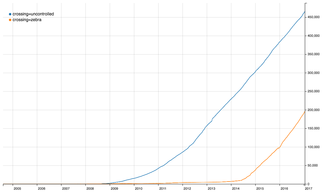
After some tagging chat on the Italian ML it came to my attention that iD is setting crossing=zebra tags on crosswalks, a tag that is not documented as value for the crossing key, besides in the UK. As I believe that using different tags for the same thing - although not really harmful - makes everyone’s lifes a bit more complicated, I thought I’d give them a hint, after all, usage of this tagging is still behind the longer standing established and documented one.
 So I created this issue: #4316.
It came up, there are already 3 tickets where the same issue had also been dismissed.
IMHO, we should take care that editing software proposes the same presets for the same objects and properties (not necessarily the same level of detail, or presets for the same things), because tag fragmentation is a burden on everyone. In this case it is very clear that crossing=zebra only came to significant use when it was added as a preset in iD in May 2014 (compare with the graph above).
Trying mapbox custom overlays, I was quite shocked from the outcome of my first attempt to show an overlay on mapbox vector tiles.
I have extracted some OSM data to display on a custom map, converted it to geojson with Martin Raifer’s osmtogeojson tool and uploaded it to mapbox via their cli suite (the only reason for using a cli tool for a one time operation is that my geojson is 80MB and mapbox only accepts max. 5MB file size for the browser upload. The cli accepts a geojson in input but doesn’t make a “dataset” of it, it directly converts them into a “tileset”, and that was apparently where the problem lay).
For example the Diocletian Thermal Baths in Rome (a museum), this is the relation in OSM, and this is what I got at first after uploading it to MapBox:  .
.
As you can see, the data in this form would be completely useless (all polygons in the dataset had been defaced in a similar way). This is because of the max-zoomlevel (indicates simplification) set to 9 by default.
Here’s how to workaround: https://www.mapbox.com/help/adjust-tileset-zoom-extent/
Probably everybody has guessed it, but here is a proof with Jan 2017 data: OSMF members are mostly living in Europe and the US, with a concentration in London, Germany, and in the US on the East Coast (Washington and NYC) and in the Silicon Valley.
I only recently discovered that Jochen Topf has published a command line tool based on his great Osmium library. The Osmium library is a C++ library optimized for working with OSM files in different formats like XML and PBF and is very fast. While the original library is geared towards developers (besides the c++ version there are also python and node bindings), the command line tool is great for normal users.
To give it a try, I decided to have a look at an Italy extract from Geofabrik I had downloaded in March and which was still lingering on my disk. Linux and Mac users know, the great potential of the shell lies in the ability to perform multiple commands in sequence by piping the output of one operation to the next tool in the chain.
Here is what I used to get a list with the last modifiers (mappers) of every object in the file, sorted by the number of contributions (only current version of undeleted objects have been counted here, but Osmium-tool also allows for analyzing full history files if I am not misguided):
osmium cat 20170302_italy.osm.pbf -f opl|cut -d' ' -f7|cut -c 2- \
         |sort|uniq -c|sort -nr|head -n 250 >italy-top250.txt
I’m not very good in using the shell, so maybe this command line can be improved, feel free to suggest improvements in the comments.
| The binary extract I used is 1.2GB and was sitting on a network share and I was using a slow dual core MacMini (this is why there aren’t spaces around the | pipe symbol, the Mac shell doesn’t like them) so it took a while (maybe half an hour), also because the sort command in the shell takes some time, but IMHO this is totally acceptable for occasional use. |
In case you are interested, this is the output (I have numbered the lines with cat -n. Unfortunately there seems to be a bug or a feature so that the markdown in this diary is removing the newlines). Needless to say, many of the higher ranks have been “cheating” by importing big amounts of data ;-)
(The format is: rank number-of-objects username)
 1 29194970 mcheckimport – 2 11687326 DarkSwan_Import –  3 4783408 simone –  4 3498422 mcheck –  5 3158791 corfedeimport –  6 2767460 Max1234-ITA –  7 2180468 nuvolabianca –  8 2097580 Alberto58 –  9 2065697 Arlas –  10 2039526 GiuseppeAmici_IT –  11 1944201 dvd0_CTRVenetoImport –  12 1846327 Al3xius –  13 1399149 kaitu –  14 1331688 pikappa79 –  15 1313970 Alecs01 –  16 1307324 Pab09 –  17 1271852 Diego%20%Guidotti –  18 872370 roscolosco –  19 802453 dieterdreist –  20 775391 Sembola –  21 759292 aldoct –  22 728828 dvdzero –  23 722980 josil –  24 698823 Alexander%20%Roalter –  25 696697 morsi –  26 688070 Stefano%20%Salvador –  27 669971 albertux –  28 666608 Fredie –  29 660525 Tizianos –  30 655812 IlBano –  31 635687 BudSpencer63 –  32 629700 GatoSelvadego –  33 590057 fayor –  34 539531 Ale_Zena_IT –  35 530778 arcanma –  36 520790 RColombo –  37 519351 ilrobi –  38 513343 Heinz_V –  39 504228 Mich74 –  40 501426 sabas88 –  41 497505 sbiribizio –  42 494637 Davlak –  43 485771 vpettenati –  44 479774 dan980 –  45 477834 DarkFlash –  46 477421 simone_girardelli –  47 470226 sabas-import –  48 466439 Gianfranco2014 –  49 460886 sorcrosc –  50 459812 dgitto –  51 451687 gpstracks –  52 444212 gvil_import –  53 431752 corfede –  54 428783 Ken%20%Hayabusa –  55 425416 pippinu –  56 424626 StePedro83 –  57 422138 sponge –  58 418211 vancori –  59 412278 adirricor –  60 410575 bellazambo –  61 405470 David%20%Paleino –  62 405372 Davide%20%Governale –  63 405364 demon_box –  64 401735 Odiug –  65 400067 voschix –  66 398116 venerdi –  67 389878 zarch –  68 388100 import%20%edifici%20%palermo%20%2014 –  69 384016 vlattanzi –  70 383706 Aury88 –  71 383522 RAFVG%20%import –  72 378605 dani64 –  73 370847 Griphon –  74 367640 Martj9 –  75 364584 rugamarcus –  76 359694 50x34 –  77 358963 Fabry –  78 349027 fedc –  79 348793 achim%20%becker –  80 340916 peppe10 –  81 335764 coso –  82 334861 mauriziobis –  83 333969 Luca%20%Dorigo –  84 332989 TheNick –  85 329211 GeofixFe –  86 321319 Lykos64 –  87 315738 makakko –  88 314594 iiizio –  89 313882 Cascafico –  90 308928 dan980-import –  91 306593 Geofreund1 –  92 305833 Goffredo –  93 297306 niubii –  94 294946 glaucos –  95 294725 Guido_RL –  96 292623 dino57 –  97 290158 colasurf –  98 286777 Ale_Zena_IT-import –  99 284524 Axel2009 – 100 281100 ualios – 101 275448 mauro742 – 102 274737 Geograficamente – 103 255450 jeawrong – 104 252317 openpablo3 – 105 252154 Eraclitus – 106 250060 Sal73x – 107 248172 Bredy – 108 246745 jaimemd – 109 237132 lorenzoguidotti – 110 235719 vrmap – 111 233713 Francesco%20%Viti – 112 225989 alessandrob – 113 222961 tyr_asd – 114 214408 carths81 – 115 213959 marcoSt – 116 213493 Paolo%20%Gianfrancesco – 117 211178 scratera – 118 206829 andgas54 – 119 206095 Michele%20%Aquilani – 120 205991 tungstentt – 121 202647 bt1950 – 122 200155 danyzeta – 123 199950 Mattia%20%P – 124 196705 hikerit – 125 195332 MarcoR – 126 195010 SingletrailMap – 127 194586 LuSirto – 128 193440 procuste – 129 191789 Dufour85 – 130 190860 FraPla – 131 188936 metamorris – 132 185613 capataz – 133 185243 marcram – 134 185019 Puccia – 135 184959 gigi2037 – 136 181906 Emistrac – 137 181777 popeye – 138 180037 mircozorzo – 139 179369 Castaman – 140 177489 rospus – 141 177303 OSM-mircozorzo_import – 142 176027 doktorpixel14 – 143 173578 trimoto – 144 172427 BogNik – 145 171617 SldrHartman – 146 171192 Patrick%20%Bous – 147 170347 gss272417 – 148 170282 Freiheit28 – 149 167360 corand – 150 166595 Terensky – 151 164870 Yiyi%20%(itwikipedia) – 152 164683 trekker48 – 153 162874 Simone%20%Saviolo – 154 162023 Cristian1989 – 155 161004 vezzo – 156 160216 Al%20%Bedo%20%Zero39 – 157 159788 Samuele%20%Battarra – 158 159243 Guido%20%Piazzi – 159 158873 Pathumthani – 160 158532 mikerpux – 161 158143 Gwilbor – 162 157604 carlobenini – 163 157005 UmbeP – 164 156884 csmggl – 165 155476 Alepoz – 166 155133 Decan – 167 154312 hotelsierra – 168 154170 Skombi – 169 153880 DnaX – 170 153149 merto – 171 151064 focus81 – 172 147773 Wave68 – 173 147389 Marco_T – 174 145891 satgps – 175 144500 remix_tj – 176 142696 slg – 177 142086 hobbie – 178 141970 effebi-sm – 179 141764 damjang – 180 140431 Diego%20%Cruciat – 181 135683 bvivi – 182 135345 Baliano – 183 134046 Anxe – 184 133018 gilbomorris – 185 130725 ilBiondo – 186 130069 Francesco_Loponte – 187 129813 Bigshot – 188 129457 Pyknite – 189 129174 Ataro – 190 129073 CatenaDiVoltri – 191 127890 farlokko – 192 127787 Luigi62 – 193 126734 flschm – 194 125972 Adriano%20%Ingallinera – 195 125776 totera – 196 124519 ALn_668 – 197 124390 Veneto_Civici_Import – 198 123901 WernerP – 199 123327 alessioz – 200 122145 frasty – 201 120691 softcake – 202 119419 spezzi64 – 203 118518 emmanuelecois – 204 117990 Marco_Fix – 205 117764 Flavio61 – 206 117604 Kiwi – 207 115936 matchman – 208 115677 pavelo – 209 114426 gmarzio – 210 112629 Sen%20%Atto – 211 110375 grfoto – 212 109726 bersanri – 213 107872 Taurus77 – 214 107541 peppo – 215 106867 Cristian%20%Testa – 216 106180 paolopoz – 217 106103 fmondini – 218 105839 maxiclimb – 219 103943 joecow – 220 103702 Davide%20%Prade – 221 103285 mux0815 – 222 102356 botdidier2020 – 223 102265 wiso_dbtopo_lodi – 224 101967 Gianluigi – 225 101051 luschi – 226 100004 pelatom – 227 99228 mikel17 – 228 98720 AlessandroAM – 229 98613 agnostico – 230 98174 mikelima – 231 97666 IA1979 – 232 97639 trianam – 233 96667 Udini – 234 96143 OpenGISData – 235 95547 Denisov21 – 236 95467 Berga – 237 95230 Jinx71 – 238 95079 StefanB_import – 239 94412 gnastyle – 240 94137 bmarco – 241 93333 Tomi – 242 92947 CouchPotato – 243 92791 lerks – 244 92506 snaut – 245 92408 Niccolo – 246 92036 bartmanxc – 247 91860 ReinerMeyer – 248 90910 g195 – 249 90336 marco%20%zudetic – 250 90303 lucadelu
If you want to install the osmium-tools on a Mac with OSX10.11 (El Capitan) or newer you’ll find that make install will not work due to System Integrity Protection which will not allow (even for the root user) to put files into some system directories and will stop with an error. While you could deactivate SIP completely by booting into protected mode and executing csrutil disable, I wouldn’t recommend you to do so and it is not needed: it should be sufficient to manually create a symlink to the binary after compilation in /usr/local/bin like this: ln -s /path-to-osmium-tool-source/build/osmium /usr/local/bin/osmium (using usr/local/bin doesn’t require the SIP to be deactivated).
Today I was asked by another (very active) mapper via email these questions:
We are currently discussing best practices for landuse mapping in Belgium. Some of the problems:
- do you use multipolygons to avoid overlapping landuse or do you split a residential landuse so you can have smaller landuses ? Or do you just overlay them ? A lot of landuse is already mapped in a rough way, so we typically have large areas of residential landuse.
- Do you include streets in residential landuse or do you exclude them so one can later add area:highway or landuse=highway ?
- I’m in favour of landcover to avoid “forests” in gardens. Which landcover proposal do you follow ? (I believe there are 2).
- what about grass/bushes in towns near highways ?
I wrote some lines how I believe it should be done. Here’s a slightly modified version:
Regarding the residential landuse, I am since almost 10 years advocating to not include roads but end the landuse at the property borders. Not only does it add more detail, because you can clearly distinguish (even without roads), parcelled land and common land, it will also be easier to add landuse=highway, i.e. the land that is legally a road. It just makes no sense from a legal point of view to add streets to the residential landuse (save maybe those areas where the streets are private). I do include driveways though, i.e. “roads” on the properties.
Clearly, public roads are road landuse, so they must not be included in residential, industrial, commercial, retail or other similar landuse.
IMHO the 3 reasons for people to include roads are
lazyness (to draw and to determine the precise border, …)
OSM standard style is not rendering place areas, so people misuse residential landuse to say: built up area
people hating “gaps” or voids in the map and think it must be “complete”, so they connect the landuse to the road and prefer to have it “wrong” rather than “incomplete”.
Of course it also depends on scale. IMHO we should try to map in a high scale, e.g. 1:500 - 1:1000 (because simplifications can be computed at need, while details can’t), but if you do your mapping in 1:10.000 and lower you would likely not represent these details and would “include” the roads (actually it wouldn’t be discernable whether they are included or not in these scales).
I also advocate to not use multipolygons for built up landuse, if it is not strictly necessary (never met a situation where it was necessary, but it might exist). It just creates unnecessary complexity and deters less experienced mappers, and leads to errors laters. It is not necessary, just make the landuse as small as you like and need. (I think that landuse is a property of the land, I don’t see it as a feature, i.e. for mapping a “residential area with a name” = part of a settlement, I suggest to use place, e.g. quarter, neighbourhood. Can even work for industrial areas (their names)). This way, you don’t mix stuff and are not forced to ignore parcels with different landuses which are also a part of the settlement part (toponomastic area).
On the other hand, when mapping in rural areas and landuses like farmland, forests and other natural features (scrubs, heath, beaches, …), multipolygons might come in handy to avoid duplicating long (and complex) ways by reusing them.
Regarding landcover, I mostly only use 3 values: trees, sand, grass, although it could be extended by more vegetation and surface types (like bushes or whatever term is correct for these, currently I use natural=scrub for thickly vegetated / unpassable areas and avoid the landcover tag there). I admit as long as it doesn’t render I still add stupid forest tags additionally, although it really is stupid ;-) I don’t know about 2 landcover proposals, but for trees, sand and grass there isn’t much to discuss I think.
If they are (legally) part of the road I would see them as landuse=highway, grass can be landcover=grass, bushes are (in my mapping but I believe it is a common agreement) natural=scrub.
This is a follow up of my recent diary entry about the centre of Rome and in parts a reply to Warin61’s comment to that post.
I believe the local people usually know where the centre is. They tell you when you ask them. Give it a try, I bet you’ll see that you get similar answers.
I would expect this most central spot to be often in front of the townhall (maybe sometimes the cathedral) or the main market square (in traditional towns) or likely both. Maybe the train station can be such a center as well (in more recent towns which developed after the railway was invented).
One criterion could be: where would you go to protest something. If you were to gather together with “all” citizens, where would you go.
Streetsigns aren’t useful from my experience. Often the centre is inside the main pedestrian area (typical for Germany, where many historic city centres have been pedestrianized) and it is generally so big that you will get signs in the outskirts indicating “city centre”, but when you arrive there will not be a sign stating “this is the city centre”, the signs will simply stop indicating a centre when you are in a central area (they might indicate “all directions” now, but that’s a different story, maybe to be told another time).
### West Berlin
In special cases there could even be several centres, e.g. Berlin (there might be a bit of a difference between big cities and smaller towns). For West-Berliners, the centre was likely Breitscheidplatz (in OSM) and as you can see it is also very close to the former main station of West Berlin, Bahnhof Zoologischer Garten).
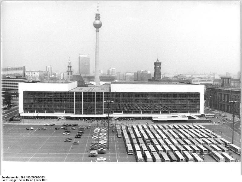
 ### East Berlin
For the people in East Berlin it was probably Alexanderplatz (in OSM) with the centre extending also to here (between tower and main town hall. There might be some other opinions because the former centre (castle) was also reclaimed by the officials, naturally (see below).
This is Alexanderplatz, you can also see the prominent tower, visible from everywhere in the city. Huge towers are generally issueing a statement of centrality). There’s also a station, but it is not important as a train station (it is a very important underground station though, with 3 lines crossing):
### East Berlin
For the people in East Berlin it was probably Alexanderplatz (in OSM) with the centre extending also to here (between tower and main town hall. There might be some other opinions because the former centre (castle) was also reclaimed by the officials, naturally (see below).
This is Alexanderplatz, you can also see the prominent tower, visible from everywhere in the city. Huge towers are generally issueing a statement of centrality). There’s also a station, but it is not important as a train station (it is a very important underground station though, with 3 lines crossing):

Another central spot and maybe the official centre during the GDR, surely during the German Empire, is the palace (Stadtschloss) (now in reconstruction), (in OSM), in times of the GDR this was the place of the “palace of the republic” (Palast der Republik), at its side there is also the national council.
In this map from 1688 you can see the central island (yellow-green). By that time there were still 2 towns, Berlin (purple) and Cöln (yellow), and this origin is likely a reason that there’s some concurrency between Alexanderplatz and the castle. The castle is signed a. Alexanderplatz is in Berlin, while the castle is in Cöln.

The Berlin castle 1900

After tearing down the castle and waiting 20 years (in the meantime they set up a permanent grandstand for their military parades on national holidays), the palace of the republic was errected (after the reunification, the Germans waited again 20 years, until they decided to demolish this “palace” and reconstruct something which imitates the imperial castle’s volume and facade).
Tearing down the castle, 1950

Grandstand for parades at the place of the former castle, 1952 (likely not perceived as a centre):

Palast der Republik, 1981:
Closeup of a parade in front of the Palast der Republik, 1978:

Palast der Republik from the inside, 1976

Here’s another map to illustrate that this is the centre of the centre (also note how the avenue “Unter den Linden” points straight to the castle (=centre), for many kilometers, and bends right in front of the centre to pass the castle). In red the former castle, gray underneath the palace of the republic, to the north-east Alexanderplatz and its tower):

The current reconstruction called Stadtschloss, (2015). Very visible how Unter den Linden bends for the castle, see it also in a much bigger scale in OSM. This is the main road, leading straight to the castle (current federal road does not completely follow the old road, but I think you can get it) and at the time used by the king to got to his residence in Potsdam. What is now there is in part also result of more recent times: the Nazi plan by Albert Speer).

The OSM crowd currently has set the centre a bit closer to the west, at the crossroads Unter den Linden and Friedrichstraße (in OSM), it’s not completely off as this is a very central place (and in the historic parts of Berlin, pre-industrialization), but it isn’t a centre where you would go to gather for protest (these would be Pariser Platz in front of Brandenburg Gate and close to the Reichstag, or Alexanderplatz).
I will soon have a look how this node moved around in OSM with the years (and also look for the previous Berlin node that was deleted in 2008).
There a very useful feature in JOSM which I just discovered now: when looking at the history diffs of an object and you choose the coordinates tab, you get a map visualizing the geometry in a map.
From time to time people are moving the Rome node.
I found it interesting to see how the position changed by the time. This is the complete position history of the Rome node:
The node creation on 2007-10-15. Back then the local map was empty and a node anywhere near the centre was perfectly fine, but the editor decided after 10 minutes he could do better and already refined to a location close to where the central point commonly is associated with (the Campidoglio).

A further refinement on 2007-10-22. Now the position is perfect (for our means), it indicates the centre of the Campidoglio with the equestrian statue of Marcus Aurelius.

This is the Piazza del Campidoglio with the equestrian statue in the centre, you can also note the concentric pavement structure indicating the centre:

Now comes a longer period of people “touching” the node without actually changing it noticably. Take a look at the distance indicator:


Until someone comes along and decides in 2011 to relocate the centre close to the Spanish Steps (although this is a famous place, it is not generally considered the “centre point”:

Just one minute later, the same user slightly adjusts the position, but keeps it at the Spanish Steps (Piazza di Spagna):

6 months later I relocate the node to the Capitoline Square (Piazza del Campidoglio):

3 years later another user starts readjusting the exact position (maybe in an attempt to optimize the rendering label positions and reduce label omissions):

Some months later, the node is moved further away from the center to the border of the square:

3 months after this, there’s a new significant relocation, this time to Piazza Navona (while it is an important place, it is not the “centre”):

The same use relocates the node, 2 months later, to the Piazza delle Rotonda (square in front of the Pantheon):

That’s where we’re still right now, but I think I will relocate it to where I believe it belongs and where most of the other mappers also have seen for it the place to be. Well, actually there’s another spot which might be brought into discussion as well: it is the place of a column just a stone’s throw away on the Roman Forum, close to the temple of Saturn, errected the Emperor Augustus, which is the official start point of the “Vie Consolarie” (main arterial roads, historically until today).
Just discovered this POI, someone offering lessons in mathematics and accepts bitcoin. Apparently he is living in the middle of the street: http://www.openstreetmap.org/node/3197308571