
Task-based fixup workflows, such as MapRoulette, To Fix, and the HOT Tasking Manager, have become popular in OSM in recent years, presenting a series of map-improvement tasks for a user to complete.
MapRoulette is wondrous in many ways but has three issues. First, if you’re using an online editor, the time taken to open each task is significant - around 3-5s to open a new instance of iD for each task. Second, that online editor has to be iD, so it’s not suited for those of us who use P2. Third, the process for creating your own tasks is fairly cumbersome, especially if you’re working on a small series of tasks to be completed by one or a few people.
Potlatch 2 now implements a fast, light way of moving through a series of tasks. It’s intended for small-scale personal work rather than planet-sized challenges. There’s no ‘resolve’ button - it’s just a way of moving between locations efficiently.
It works like this:
Create (or find) a GPX or GeoJSON file containing the locations.
If it’s a GPX file, it should contain waypoints. Each one can have a description in a <desc>, <cmt>, or <sym> element.
If it’s a GeoJSON file, it should contain Point features. Each one can have a description in the ‘name’ property (or, failing that, the first property).
Open it in Potlatch 2 with the Tasks button.
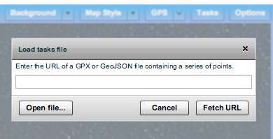
You can either load a file from disk, or type a URL and click ‘Fetch URL’. (For the latter, note that the usual nonsense about needing a crossdomain.xml file at the root of the server applies, sadly.)
Move from task to task with the palette.
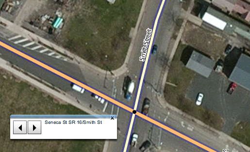
The map will centre on the first location. When you want to go onto the next one, click the forward arrow. To go to the previous one, click the back arrow. And that’s it.
Try it for yourself using a GPX file of waypoints. If you don’t have one to hand, these files from the Adventure Cycling Association of long-distance cycle routes across the US are fun.
I’d be interested to hear of other formats this could support, and further suggestions for improvement; and it would be lovely if authors of other editors were also interested in exploring the idea.
Discussion
Comment from mvexel on 20 December 2014 at 19:40
This is an excellent improvement Richard! I am guessing it could be used with any Overpass Turbo GeoJSON export as well?
I am currently working on direct GeoJSON support for MapRoulette (as required by the Magical MapRoulette Machine) so I am hoping that geoJSON can grow to be some sort of microtask format standard for OSM.
Comment from emacsen on 21 December 2014 at 01:27
Not sure what this means.
MR can support PL2 as easily as iD. The issue was too many buttons.
Comment from Tom Chadwin on 23 December 2014 at 05:44
JSONP supported, to avoid such nonsense?
Comment from saintam1 on 21 April 2015 at 22:18
This is proving to be tremendously useful. It has vastly improved my Potlatch workflow. Thanks!
Comment from joost schouppe on 9 June 2015 at 06:30
Yes, this is very practical. Strangely enough it didn’t work with the GPX output for this Overpass Turbo Query, but it did when exported to GeoJSON.
Comment from DaveF on 6 January 2016 at 15:38
Hi Thanks for this. Looks like it could be useful, except:
of geojson file { "type": "Feature", "id": "node/-631", "properties": { "type": "node", "id": "-631", "tags": { "name": "Keynsham Masonic Hall", "addr:postcode": "BS31 1SR", "businesstype": "Other catering premises", "addrline1": "99 Bath Road", "addrline2": "Keynsham", "addrline3": "Bristol", "addrline4": "Bath And North East Somerset", "addr:housenumber": "99", "addr:street": "Bath Road", "fhrs:rating": "5", "fhrs:authority": "Bath and North East Somerset", "fhrs:id": "205662", "fhrs:inspectiondate": "2012-06-18" }, "relations": [], "meta": {} }, "geometry": { "type": "Point", "coordinates": [ -2.485158, 51.412579 ] } }, It jumps between locations, but doesn't display the name tag: 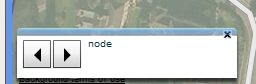 Any ideas?Comment from DaveF on 6 January 2016 at 15:39
PS woops. How do I post prettified code here?
Comment from DaveF on 7 January 2016 at 00:06
Ah, don’t worry, I forgot that Overpass, for some reason, converts OSM to Geojson differently depending on whether the Turbo site or osmtogeojson is used. I deleted the unnecessary nodes & it works fine.
Thanks for a great utility.